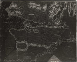
Item is a sheet with three nautical charts. The main chart depicts Burrard Inlet from Atkinson Point [Point Atkinson] in the west to the "townsite of Port Moody" in the east. The inset charts depict Vancouver Harbour and the Second Narrows.
Item is a nautical chart of Vancouver Harbour from Second Narrows in the west to Port Moody in the east, showing soundings in fathoms, tidal information, anchorages, beacons, and waterfront businesses. Street names are shown on land areas.
Item is a nautical chart of Vancouver Harbour from First Narrows in the west to Second Narrows in the east, showing soundings in fathoms, tidal information, anchorages, beacons, and waterfront businesses. Street names are shown on land areas.
item is a nautical chart of Burrard Inlet and Vancouver Harbour from Point Grey in the west to Second Narrows in the east, showing soundings in fathoms, tidal information, anchorages, beacons, and waterfront businesses. Street names are shown on land areas. A Royal Canadian Air Force bombing range at Jericho Beach is identified as a danger area.
Item is a copy of a portion of a manuscript map of Burrard Inlet, created during the H.M.S. Plumper survey of the area. Sheet shows the eastern portion of the Inlet, including the southern portion of the North Arm.