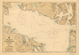
Showing 3 results

Archival description
Howe Sound (B.C.) Nautical charts
Print preview View:

2 results with digital objects Show results with digital objects

Howe Sound and Howe Sound (southern portion)

Item contains two nautical charts of Howe Sound; one chart shows the southern portion (Bowen Island and Gambier Island) only, while the other shows the Sound from Burrard Inlet in the south to Squamish in the north. Charts show soundings in fathoms, tidal information, bench marks, locations of cables, and characteristics of land at shorelines.

Fraser River to north east point of Texada Island : including Howe Sound and Jervis Inlet

Item is a nautical chart depicting the southern portion of the Strait of Georgia. Land shown includes (south to north): Gulf Islands, Vancouver Island to Nanoose Harbour, Vancouver area, Bowen Island, Gambier Island, Howe Sound, Seechelt Peninsula, and north to Queen's Reach. Inset map is of Tucker Bay on Lasqueti Island. The illustrations are of Georgina Point Lighthouse, Active Pass and the north shore of Gabriola Island.