
Area bounded by Kaslo St., 14th Ave., Renfrew St. and 18th Ave. : lands affected by proposed filling of Still Creek

British Columbia : Port Moody sheet : west of seventh, east and west of coast meridians

British Columbia federal constituencies

British Columbia. Port Moody
![Canadian Pacific map of Vancouver [west half]](/uploads/r/null/f/a/fa49266d21715d75ce93883012d471657dd058b90843927ec82b44d2bb42b007/f12ea9a5-4914-4db8-bda9-312aa2e2ccef-MAP10_142.jpg)
Canadian Pacific map of Vancouver [west half]

Canadian Pacific Railway plan of foreshore at Vancouver, Burrard Inlet as shewn on plan fyled in Department of Railways and Canals, 31st March, 1886

Canadian Pacific Railway. Plan of part of branch line from Port Moody. A point on main line C.P.R. to English Bay, B.C.

Champlain Heights : D.L. 334, group one, N.W.D.

City of New Westminster British Columbia

City of Vancouver

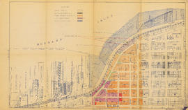
City of Vancouver : Canadian Pacific town site

City of Vancouver : Canadian Pacific town site

City of Vancouver : Canadian Pacific town site

City of Vancouver : residential lots, Area B, Champlain Heights : page 1

City of Vancouver : residential lots, Area B, Champlain Heights : page 2
![D.L. [District Lot] 526](/uploads/r/null/c/b/4/cb45fc2541156cf0f1c89b637733e961198017ddd4aa199ba866f1150856a8ba/dfb19024-a115-4097-9258-559e228c275d-MAP332_142.jpg)
D.L. [District Lot] 526

East Vancouver Heights
![[First section of] Shaughnessy Heights](/uploads/r/null/c/d/0/cd05f96b7e9f01fee4ba2afe83ac83cef9d70b3cf83d3ba8c4ebe5a0a20a429d/0d2ec941-063b-4722-8d84-aff283b273f6-MAP329_142.jpg)
[First section of] Shaughnessy Heights

Hastings Townsite : Nanaimo Street to Renfrew Street and 13th Avenue to Strathcona Road (22nd Avenue)

Hastings Townsite : Nanaimo Street to Renfrew Street and Burrard Inlet to Cambridge Street

Hastings Townsite : Nanaimo Street to Renfrew Street and Strathcona Road (22nd Avenue) to Government Road (29th Avenue)

Hastings Townsite : Renfrew Street to Rupert Street and 5th Avenue to 13th Avenue

Hastings Townsite : Renfrew Street to Rupert Street and Strathcona Road (22nd Avenue) to Government Road (29th Avenue)

Hastings Townsite : Rupert Street to Boundary Road and 5th Avenue to 13th Avenue

Hastings Townsite : Rupert Street to Boundary Road and Pender Street to Charles Street

Hastings Townsite : Rupert Street to Boundary Road and Strathcona Road (22nd Avenue) to Government Road (29th Avenue)

Indexed guide map of the city of Vancouver and suburbs
Land use : Semlin Drive to Nanaimo Street and Burrard Inlet to Triumph Street
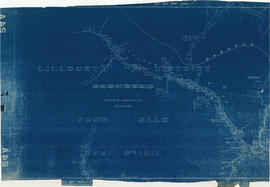
Lillooet District from sale April 6th 1911

Lot numbers, boundaries, railway lines and street names in the municipality of Point Grey
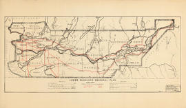
Lower Mainland Regional Plan : base map

Lower Mainland, B.C. : land subdivision

Map and guide of Greater Vancouver

Map of Grandview and east end

Map of Granville Street, downtown Vancouver

Map of Marpole

Map of New Westminster District, B.C

Map of New Westminster District, B.C.

Map of New Westminster District, B.C.

Map of part of the New Westminster District shewing the proposed new municipality of Burnaby

Map of Richmond municipality
![Map of the business portion of the City of Vancouver, British Columbia [early street paving]](/uploads/r/null/7/1/7187f671d2770050eb87f7f397a10ea92bf0bc593b0a186e3a4bf341b3d26e42/8770145a-b925-4eef-82ac-e397f61a65aa-Map1163_142.jpg)
Map of the business portion of the City of Vancouver, British Columbia [early street paving]

Map of the Fraser Valley showing railway lines and district lots

Map of the Lower Mainland showing municipal boundaries and lot numbers

Map of the south-western part of British Columbia

Map of West Vancouver and vicinity

Map of Western Canada
![Municipality of North Vancouver [Burrard Inlet]](/uploads/r/null/6/d/6d0d9a4b75b38672c56aa89a5984fe2d0e6d66be85f6f375cbe8e2fd7ac94a98/577914e1-3de2-478b-a629-5f391731387a-MAP588_142.jpg)
Municipality of North Vancouver [Burrard Inlet]

Municipality of South Vancouver

Municipality of South Vancouver