City of Vancouver : residential lots, Area B, Champlain Heights : page 1
City of Vancouver : residential lots, Area B, Champlain Heights : page 2
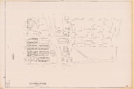
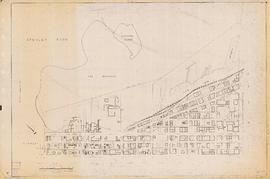
East Vancouver Heights
Hastings Townsite : Nanaimo Street to Renfrew Street and 13th Avenue to Strathcona Road (22nd Avenue)
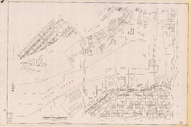
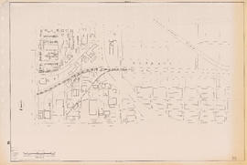
Hastings Townsite : Nanaimo Street to Renfrew Street and Burrard Inlet to Cambridge Street
Hastings Townsite : Nanaimo Street to Renfrew Street and Strathcona Road (22nd Avenue) to Government Road (29th Avenue)
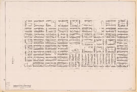
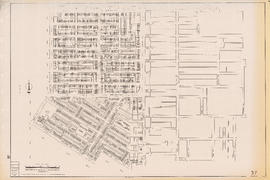
Hastings Townsite : Renfrew Street to Rupert Street and 5th Avenue to 13th Avenue
Hastings Townsite : Renfrew Street to Rupert Street and Strathcona Road (22nd Avenue) to Government Road (29th Avenue)
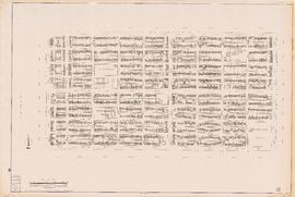
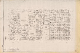
Hastings Townsite : Rupert Street to Boundary Road and 5th Avenue to 13th Avenue
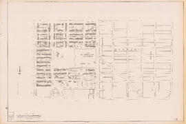
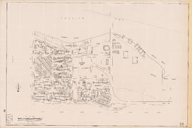
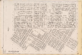
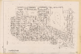
Hastings Townsite : Rupert Street to Boundary Road and Pender Street to Charles Street
Hastings Townsite : Rupert Street to Boundary Road and Strathcona Road (22nd Avenue) to Government Road (29th Avenue)
Indexed guide map of the city of Vancouver and suburbs
Map of the Fraser Valley showing railway lines and district lots
Map of West Vancouver and vicinity
Sectional map of Vancouver showing streets, block and lot outlines, and building perimeters : Map 10 : Clark Drive to Nanaimo Street and Burrard Inlet to Frances Street/Ferndale Street
Sectional map of Vancouver showing streets, block and lot outlines, and building perimeters : Map 11 : Nanaimo Street to Rupert Street and Burrard Inlet to McGill Street
Sectional map of Vancouver showing streets, block and lot outlines, and building perimeters : Map 12 : Nanaimo Street to Cassiar Street and McGill Street/Wall Street to Pender Street
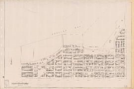
Sectional map of Vancouver showing streets, block and lot outlines, and building perimeters : Map 13 : Rupert Street to Boundary Road and Burrard Inlet to Eton Street
Sectional map of Vancouver showing streets, block and lot outlines, and building perimeters : Map 14 : Cassiar Street to Boundary Road and Eton Street to Pender Street
Sectional map of Vancouver showing streets, block and lot outlines, and building perimeters : Map 15 : Rupert Street to Boundary Road and Pender Street to Kitchener Street
Sectional map of Vancouver showing streets, block and lot outlines, and building perimeters : Map 16 : Rupert Street to Boundary Road and Kitchener Street to 5th Avenue
Sectional map of Vancouver showing streets, block and lot outlines, and building perimeters : Map 17 : Nanaimo Street to Rupert Street and Pender Street to Charles Street
Sectional map of Vancouver showing streets, block and lot outlines, and building perimeters : Map 18 : Nanaimo Street to Rupert Street and Charles Street to 5th Avenue
Sectional map of Vancouver showing streets, block and lot outlines, and building perimeters : Map 19 : Clark Drive to Nanaimo Street and Frances Street/Ferndale Street to 2nd Avenue
Sectional map of Vancouver showing streets, block and lot outlines, and building perimeters : Map 20 : Main Street to Clark Drive and Prior Street to 2nd Avenue/Great Northern Way
Sectional map of Vancouver showing streets, block and lot outlines, and building perimeters : Map 21 : False Creek waterfront and adjacent buildings from foot of Drake Street to Main Street
Sectional map of Vancouver showing streets, block and lot outlines, and building perimeters : Map 22 : Maple Street to Drake Street and Vanier Park/Sunset Beach to 4th Avenue
Sectional map of Vancouver showing streets, block and lot outlines, and building perimeters : Map 23 : Balaclava Street to Maple Street and English Bay to 3rd Avenue
Sectional map of Vancouver showing streets, block and lot outlines, and building perimeters : Map 24 : Jericho Beach Park to Balaclava Street and English Bay to 4th Avenue
Sectional map of Vancouver showing streets, block and lot outlines, and building perimeters : Map 25 : Blanca Street to Jericho Beach Park and English Bay to 4th Avenue
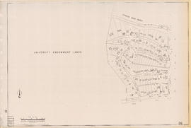
Sectional map of Vancouver showing streets, block and lot outlines, and building perimeters : Map 26 : University Endowment Lands to Blanca Street and N.W. Marine Drive to 4th Avenue
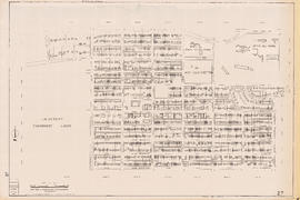
Sectional map of Vancouver showing streets, block and lot outlines, and building perimeters : Map 27 : Blanca Street to Camosun Street and 4th Avenue to 14th Avenue
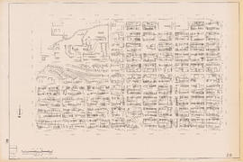
Sectional map of Vancouver showing streets, block and lot outlines, and building perimeters : Map 28 : Camosun Street to Balaclava Street and 4th Avenue to 14th Avenue
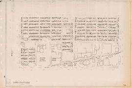
Sectional map of Vancouver showing streets, block and lot outlines, and building perimeters : Map 29 : Balaclava Street to Maple Street and 3rd Avenue to 14th Avenue
Sectional map of Vancouver showing streets, block and lot outlines, and building perimeters : Map 30 : Maple Street to Oak Street and 3rd Avenue/6th Avenue to 14th Avenue
Sectional map of Vancouver showing streets, block and lot outlines, and building perimeters : Map 31 : Oak Street to Main Street and 6th Avenue/4th Avenue to 16th Avenue
Sectional map of Vancouver showing streets, block and lot outlines, and building perimeters : Map 33 : Clark Drive to Nanaimo Street and 2nd Avenue to 13th Avenue
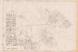
Sectional map of Vancouver showing streets, block and lot outlines, and building perimeters : Map 34 : Nanaimo Street to Rupert Street and 5th Avenue to Grandview Highway North
Sectional map of Vancouver showing streets, block and lot outlines, and building perimeters : Map 35 : Rupert Street to Boundary Road and 5th Avenue to Grandview Highway
Sectional map of Vancouver showing streets, block and lot outlines, and building perimeters : Map 36 : Rupert Street to Boundary Road and Grandview Highway to 22nd Avenue
Sectional map of Vancouver showing streets, block and lot outlines, and building perimeters : Map 37 : Rupert Street to Boundary Road and 22nd Avenue to Wellington Avenue/Monmouth Avenue
Sectional map of Vancouver showing streets, block and lot outlines, and building perimeters : Map 38 : Nanaimo Street to Rupert Street and Grandview Highway to 22nd Avenue
Sectional map of Vancouver showing streets, block and lot outlines, and building perimeters : Map 39 : Nanaimo Street to Rupert Street and 22nd Avenue to Kingsway/Vanness Avenue
Sectional map of Vancouver showing streets, block and lot outlines, and building perimeters : Map 4 : Chilco Street to Burrard Street and Coal Harbour to Robson Street
Sectional map of Vancouver showing streets, block and lot outlines, and building perimeters : Map 40 : Inverness Street to Nanaimo Street and 13th Avenue to 22nd Avenue/24th Avenue
Sectional map of Vancouver showing streets, block and lot outlines, and building perimeters : Map 42 : Oak Street to Ontario Street and 16th Avenue to 28th Avenue
Sectional map of Vancouver showing streets, block and lot outlines, and building perimeters : Map 43 : East Boulevard to Oak Street and 14th Avenue to Laurier Avenue