Showing 15 results

Archival description
Fire insurance
Print preview View:

6 results with digital objects Show results with digital objects

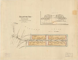
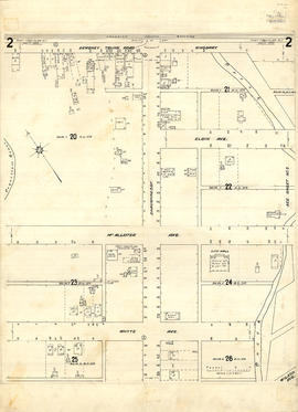
Insurance plan of Port Coquitlam : key plan and sheet 1

Part contains the key plan for the insurance plan of Port Coquitlam, an inset map of the area bounded by Shaughnessy Street, Central Avenue, and Rindall Avenue, and a section of the insurance plan covering Dewdney Trunk Road where it crosses the Coquitlam River. Map shows legal descriptions, street widths, building dimensions and types (dwelling, office, industrial, other commercial use), names of businesses, and other features of the built environment relevant to insurance claims.

Insurance plan of Port Coquitlam : sheet 2

Part contains a section of the insurance plan covering the area bounded by the Coquitlam River, an unnamed creek, Dewdney Trunk Road, and Whyte Avenue. Map shows legal descriptions, street widths, building dimensions and types (dwelling, office, industrial, other commercial use), names of businesses, and other features of the built environment relevant to insurance claims.

Insurance Plan of Port Coquitlam : sheet 3

Part contains a section of the insurance plan covering the area bounded by an unnamed creek, Kingsway Avenue, and Atkins Avenue. Map shows legal descriptions, street widths, building dimensions and types (dwelling, office, industrial, other commercial use), names of businesses, and other features of the built environment relevant to insurance claims.

Insurance Plan of Port Coquitlam : sheet 4

Part contains a section of the insurance plan covering the area bounded by Chester Street, Cambridge Street, Grant Avenue, and Suffolk Avenue. Map shows legal descriptions, street widths, building dimensions and types (dwelling, office, industrial, other commercial use), names of businesses, and other features of the built environment relevant to insurance claims.

Insurance plan of Port Coquitlam, British Columbia, situated on the Canadian Pacific Railway 17 miles east of Vancouver

Item is a portion of a fire insurance plan of Port Coquitlam. Map shows legal descriptions, street widths, building dimensions and types (dwelling, office, industrial, other commercial use), names of businesses, and other features of the built environment relevant to insurance claims. This four-sheet portion is missing the key to symbols and abbreviations.

Plan of Vancouver, 1889 [fire map]

Item is a 1936 black and white reproduction of the 1889 Dakin fire insurance map. Item contains a legend and key plan. Map shows city block numbers, subdivision lot numbers, water pipes, sewer pipes, street names, and buildings.