- AM1594-: MAP 851
- Item
- 19--
Part of City of Vancouver Archives technical and cartographic drawing collection
Map shows Juan de Fuca Strait, the San Juan Islands and the southern portion of Vancouver Island.
29 results with digital objects Show results with digital objects
Part of City of Vancouver Archives technical and cartographic drawing collection
Map shows Juan de Fuca Strait, the San Juan Islands and the southern portion of Vancouver Island.

Part of City of Vancouver Archives technical and cartographic drawing collection
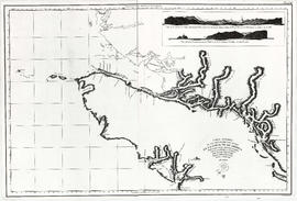
Item is a map showing the Pacific Coast of British Columbia and Washington and Oregon states as surveyed by French explorer Jean-Francois de Galaup (Laperouse) in 1786, and the routes of his ships Astrolabe and Boussole. The map shows the Pacific coastline from Cap Rond (Tillamook Head) in Oregon at latitude 45 degrees and 40 minutes in the south to Baeie de Clonard (Beresford Bay, northwestern tip of Haida Gwaii) in British Columbia at latitude 54 degrees and 10 minutes in the north. Other major place names on the map include Nootka, Pointe Boisee, Baie St. Louis, Iles de Sartine, Mont Fleurieu, Cap Fleurieu, Cap Hector, Mont de la Touche, Baie de la Touche, and Baie de Clonard. Vancouver Island is shown as part of the mainland. Map includes latitudes and longtitudes as well as indication of elevations. Map is a plate from the "Atlas de Voyage de la Perouse".

A chart shewing part of the coast of N.W. America
Part of City of Vancouver Archives technical and cartographic drawing collection
Item is a map, which is a coloured reproduction made in 1974 of one of the charts made in 1798 of George Vancouver's surveys of the Pacific coast of North America. The plate depicts the area from Fitzhugh Sound, north to Prince Frederick Sound. The routes taken by Vancouver are marked. Inset map shows a survey of Port Stewart.
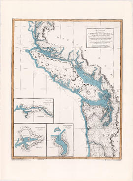
A chart shewing part of the coast of N.W. America
Part of City of Vancouver Archives technical and cartographic drawing collection
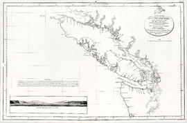
Item is a map, which is a coloured reproduction made in 1974 of one of the charts made in 1798 of George Vancouver's surveys of the Pacific coast of North America. The plate depicts the area from Cape Lookout, north to Cape Swain. The routes taken by Vancouver are marked. Inset map shows a survey of Port Stewart. Three inset maps show the entrance of the Columbia River, Port of Discovery and Gray's Harbour. The routes taken by Captain Vancouver are marked.
Part of City of Vancouver Archives technical and cartographic drawing collection
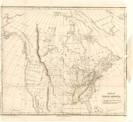
Item is a map showing "Mr. Stuart's route through the United States, and Canada in 1828, 29 & 30" and "the boundary of the United States, both on the side of the British Possessions, & those in Mexico." The northern border of United States territory west of the Rocky Mountains is incorrectly noted at 54/40, to reflect American claims of the time.

Map of a portion of British Columbia
Part of City of Vancouver Archives technical and cartographic drawing collection
Item is a map showing exploration routes by Lieutenant Palmer, R.E., May and June 1859; Lieutenant Mayne, R.N., May 1859; and Lieutenant Palmer, R.E., Sept. & Oct. 1859. The map also shows "practicable roads" in the southwestern portion of British Columbia. Annotations are colour added to the map to more easily distinguish the different routes depicted.

British Columbia : an historical illustrated map commemorating two centenaries, 1867-1967, 1866-1966
Part of City of Vancouver Archives technical and cartographic drawing collection
Item is an illustrated map is of the province of British Columbia, created to commemorate the Canadian Centennial.
The central component of the sheet is a reproduction of part of a map from the Department of Lands; surrounding the map are illustrations depicting prominent historical figures and accompanying information. The map has been annotated with the routes of Captain Cook's voyage (1778-1779), Captain Vancouver's voyage (1792-1794), and the overland routes of Sir Alexander MacKenzie (1793), David Thompson (1806-1811) and Simon Fraser (1808).
Portraits, accompanied by short biographies, are included for Cook, Vancouver, MacKenzie, Fraser and Sir James Douglas. Six other portraits are of the early governors of the colony of Vancouver Island and of British Columbia between 1849 and 1876. An illustration of the Great Seal of the Realm attached to the royal commission appointing Richard Blanshard the first governor of the colony of Vancouver Island is shown. A short textual description of the birth and expansion of British Columbia is included with an accompanying illustration of the expansion of the province over time.

The Russian discoveries from the map published by the Imperial Academy of St. Petersburg
Part of Major Matthews collection
Item is a map showing the locations of Russian exploration discoveries around the Pacific coast, as well as some discoveries by other explorers such as Juan de Fuca and Sir Francis Drake. Area shown includes Russia, China, Japan, Northern Ocean, Pacific Ocean and North America. Includes a explanation of Russian names on the map.
Carte de la cote N.O. de l' Amerique et de la cote N.E. de l'Asie
Part of City of Vancouver Archives technical and cartographic drawing collection
Item is a map showing the north west coast of America and the north east coast of Asia. Inset maps shows the entrance to Nootka Sound.

Carte de la riviere de Cook dans la partie N.O. de l'Amerique
Part of City of Vancouver Archives technical and cartographic drawing collection
Item is a nautical chart showing "Cook's River" [Cook Inlet, Alaska]; the inset chart shows Oonalaska Island and gives soundings for "Samganoodha harbour" and the waters around the island.

Chart of the n.w. coast of America and n.e. coast of Asia explored in the years 1778 and1779
Part of City of Vancouver Archives technical and cartographic drawing collection
Item is a re-printed version of a geographical map of the territories bordering on the northern Pacific.
Part of City of Vancouver Archives technical and cartographic drawing collection
Map shows the discoveries made in 1792 on the north-west coast of North American by examining Juan de Fuca Strait and the corresponding navigable channels, prepared for Dionisio Galiano and Captain Valdes, naval captains of the Royal (Spanish) Fleet in the year 1795.
Part of City of Vancouver Archives technical and cartographic drawing collection
Item is a reproduction of a map depicting the Spanish explorations of the north-west coast of North American in 1795, specifically depicting the northern end of Vancouver Island and the adjacent mainland. Illustrations are views of the entrance to Nootka Sound, and a view of "Cabo Frondoso" (Cape Cook?).

Vancouver Island and adjacent shores of British Columbia
Part of City of Vancouver Archives technical and cartographic drawing collection

Haro Strait and middle channel
Part of City of Vancouver Archives technical and cartographic drawing collection
Item is a reproduction of a nautical chart of Haro Strait and middle channel between Vancouver Island and the mainland.

Kaart van de noord-west kust van Amerika en de noord-oost kust van Asia
Part of City of Vancouver Archives technical and cartographic drawing collection
Item is a map showing the north Pacific Ocean, including the north west coast of North America and the north east coast of Asia.

Part of City of Vancouver Archives technical and cartographic drawing collection
Item is a reproduction of a map depicting North America, Central America, South America, the southern portion of Greenland, northwestern Europe and northeastern Asia.
Part of City of Vancouver Archives technical and cartographic drawing collection
Item is a reproduction of a map depicting North American and South America.

Nova totius terrarum orbis geographica ac hydrographica tabula
Part of City of Vancouver Archives technical and cartographic drawing collection
Item is a reproduction of a geographical and hydrographical map of the world created in 1621.

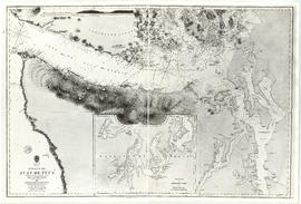
A portion of a map showing the coasts of Peru and Chile
Part of City of Vancouver Archives technical and cartographic drawing collection
Item is a photographic reproduction of a portion of a map of the Americas, depicting the Pacific coasts of South America.
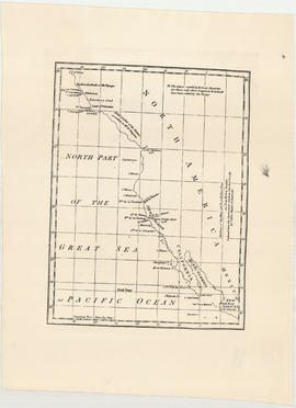
North part of the great sea, Pacific Ocean
Part of City of Vancouver Archives technical and cartographic drawing collection
Item is a reproduction of a sketch map of the Pacific coast of North American from C. St. Elias in the north to San Blas in the south.
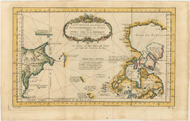
Part of City of Vancouver Archives technical and cartographic drawing collection
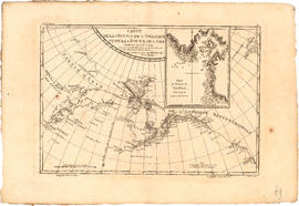
Item is a map engraved by French cartographer M. Bellin showing eastern Asia and the northern part of North America, mainly Canada. Includes notes as to areas of the west coast of North America explored by the Russians in 1728 and 1741, the exploration of the entrance of the Strait of Juan de Fuca in 1592 and 1603, as well as exploration on the east coast of Asia. Map also includes latitudes and longitudes, some place names, major bodies of water and indicates mountainous regions. Printed on the bottom of the map is "Tome XV" and "No. 4."
[Text and illustrations relating to Captain Cook's voyage to North America]
Capt. Scott's discovery of the South Pole : [advertisement for a lecture]
Simon Fraser, explorer and fur trader
"Stanley Smith's travels" in the coast mountains, 1893
Bodega to Clayoquot in 1790 in a long boat
Pilot Commander Don Jose Maria Narvaez : 1791
Address on [the discovery of the Northwest Passage by land] to the Canadian Club, March 13, 1907
Conquest of the Northwest Passage by R.C.M.P. Schooner St. Roch
North West Passage "R.C.M.P. St. Roch" by Corporal M.J. Olsen, R.C.M.P., 1928-1944
Capilano Creek : discovery of source, 1890
Discovery of the site of Vancouver city by Jose Maria Narvaez in 1791
Early maps of the British Columbia area
Stefansson, Viljalmur, Arctic explorer
Part of Major Matthews collection

Cape Caution to Port Simpson including Hecate Strait and part of Queen Charlotte Islands
Part of City of Vancouver Archives technical and cartographic drawing collection
Part of City of Vancouver Archives technical and cartographic drawing collection
Item is a reproduction of a map of the Strait of Juan de Fuca, including the southern tip of Vancouver Island, the southern Gulf Islands and adjacent mainland, Admiralty Inlet and Puget Sound.

Nova totius Americae descriptio
Part of City of Vancouver Archives technical and cartographic drawing collection
Item is a reproduction of a map depicting North America, Central America and South America.

Algemeene kaart : van de ontdekkingen van Kapit. J. Cook
Part of City of Vancouver Archives technical and cartographic drawing collection
Item is a reproduction of a map of the discoveries made by Captain J. Cook during his three voyages.
Robert, H.

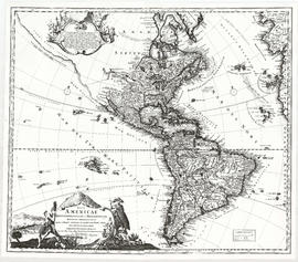
A map of the whole continent of America divided into North and South and West Indies
Part of City of Vancouver Archives technical and cartographic drawing collection
Item is a reproduction of a map which depicts North America, South America and the West Indies. An inset map on the lower left-hand corner shows Baffin Island and Hudson's Bay. The item also includes lists of islands and regions in the Americas belonging to each of Great Britain, France, Spain, Portugal, Denmark and the Dutch, as per the terms of the Treaty of Paris. The item also includes a list of nine relevant articles defined in the 1763 Paris treaty.

Part of City of Vancouver Archives technical and cartographic drawing collection
Map shows the Pacific Coast from Prince William Sound in the north though the Queen Charlotte Islands, Vancouver Island, Port S. Francisco and Sn. Diego to Sn. Domingo in the south.
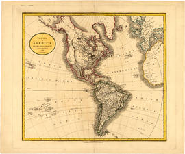
A new map of America, from the latest authorities
Part of City of Vancouver Archives technical and cartographic drawing collection
Map shows North America, South America, Greenland, islands in the Pacific and Atlantic oceans and parts of western Africa and western Europe.

Part of City of Vancouver Archives technical and cartographic drawing collection
Primary map shows towns, states and territories in North America and Central America. An ancillary map shows the "Hawaiian Group or Sandwich Islands".