- AM1594-: MAP 851
- Item
- 19--
Part of City of Vancouver Archives technical and cartographic drawing collection
Map shows Juan de Fuca Strait, the San Juan Islands and the southern portion of Vancouver Island.
9 results with digital objects Show results with digital objects
Part of City of Vancouver Archives technical and cartographic drawing collection
Map shows Juan de Fuca Strait, the San Juan Islands and the southern portion of Vancouver Island.

Part of City of Vancouver Archives technical and cartographic drawing collection
Item is a map showing the Pacific Coast of British Columbia and Washington and Oregon states as surveyed by French explorer Jean-Francois de Galaup (Laperouse) in 1786, and the routes of his ships Astrolabe and Boussole. The map shows the Pacific coastline from Cap Rond (Tillamook Head) in Oregon at latitude 45 degrees and 40 minutes in the south to Baeie de Clonard (Beresford Bay, northwestern tip of Haida Gwaii) in British Columbia at latitude 54 degrees and 10 minutes in the north. Other major place names on the map include Nootka, Pointe Boisee, Baie St. Louis, Iles de Sartine, Mont Fleurieu, Cap Fleurieu, Cap Hector, Mont de la Touche, Baie de la Touche, and Baie de Clonard. Vancouver Island is shown as part of the mainland. Map includes latitudes and longtitudes as well as indication of elevations. Map is a plate from the "Atlas de Voyage de la Perouse".
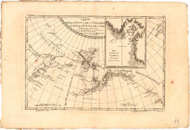
Carte de la cote N.O. de l' Amerique et de la cote N.E. de l'Asie
Part of City of Vancouver Archives technical and cartographic drawing collection
Item is a map showing the north west coast of America and the north east coast of Asia. Inset maps shows the entrance to Nootka Sound.

Carte de la riviere de Cook dans la partie N.O. de l'Amerique
Part of City of Vancouver Archives technical and cartographic drawing collection
Item is a nautical chart showing "Cook's River" [Cook Inlet, Alaska]; the inset chart shows Oonalaska Island and gives soundings for "Samganoodha harbour" and the waters around the island.
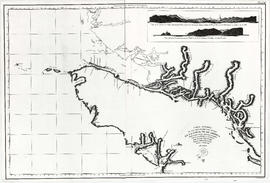
Part of City of Vancouver Archives technical and cartographic drawing collection
Item is a reproduction of a map depicting the Spanish explorations of the north-west coast of North American in 1795, specifically depicting the northern end of Vancouver Island and the adjacent mainland. Illustrations are views of the entrance to Nootka Sound, and a view of "Cabo Frondoso" (Cape Cook?).

Kaart van de noord-west kust van Amerika en de noord-oost kust van Asia
Part of City of Vancouver Archives technical and cartographic drawing collection
Item is a map showing the north Pacific Ocean, including the north west coast of North America and the north east coast of Asia.

Nova totius Americae descriptio
Part of City of Vancouver Archives technical and cartographic drawing collection
Item is a reproduction of a map depicting North America, Central America and South America.

Part of City of Vancouver Archives technical and cartographic drawing collection
Map shows the Pacific Coast from Prince William Sound in the north though the Queen Charlotte Islands, Vancouver Island, Port S. Francisco and Sn. Diego to Sn. Domingo in the south.
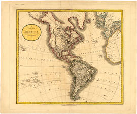
A new map of America, from the latest authorities
Part of City of Vancouver Archives technical and cartographic drawing collection
Map shows North America, South America, Greenland, islands in the Pacific and Atlantic oceans and parts of western Africa and western Europe.

Part of City of Vancouver Archives technical and cartographic drawing collection
Primary map shows towns, states and territories in North America and Central America. An ancillary map shows the "Hawaiian Group or Sandwich Islands".