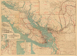
South western British Columbia
- AM75-F26-: LEG1374.11
- Item
- 1955
Item is a map of southwestern British Columbia and northwestern Washington showing cities, municipalities, and settlements, post offices, government agents, railways, roads, ferry and steamship routes, air and seaplane ports, parks, campsites, glaciers, customs ports of entry, and elevations of mountains. Inset maps show the islands north of Cape Scott and the Seattle region. An small key map shows the primary map's location in relation to the rest of British Columbia and other maps published in the same series.