Showing 59 results

Archival description
Urban renewal With digital objects English
Print preview View:

City of Vancouver redevelopment : project 2, area "H" and part of "B" : aerial photograph : boundaries of clearance areas : project 2 (areas 8 and 9)

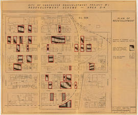
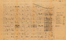
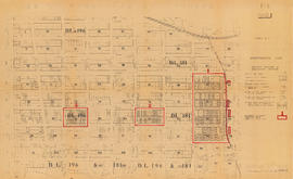
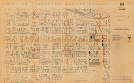
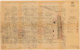
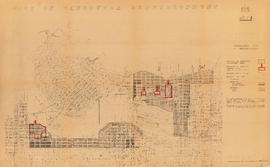
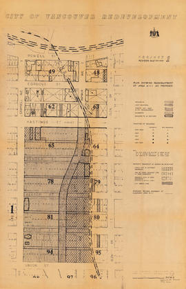
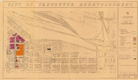
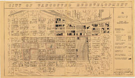
Item is a map annotated to show the boundaries of Project no. 2 areas 8 and 9. Area 8 corresponds roughly to the area bounded by Scotia Street, Brunswick Street, 2nd Avenue, and 8th Avenue. Area 9 corresponds roughly to the area bounded by Guelph Street, Fraser Street, 5th Avenue, and 7th Avenue. Base map is a reproduction of an aerial photograph showing the area bounded by Main Street, Clark Drive, Terminal Avenue, and Broadway.

City of Vancouver redevelopment project no. 1 : redevelopment scheme : area D-4

Item is a map showing the boundary of clearance areas for Project no. 1 area D-4, light industrial sites to be created by the clearance, and sites and buildings to be retained. Map has been annotated to highlight light industrial sites; some sites are marked with notes of unclear meaning. Base map covers the area bounded by Burrard Street, Granville Street, 1st Avenue, and 6th Avenue.

City of Vancouver redevelopment : project 2, area A-2

Item is a map annotated with numbers, letters, and outlines on some properties in the Strathcona area. The significance of the annotations is unclear. Base map shows streets and legal addresses from Main Street to Clark Drive and the waterfront to Atlantic Street.

City of Vancouver redevelopment : project 1, area A-1 : identification plan : property included in acquisition program

Item is a Planning Department map showing ownership of property included in the acquisition program. Base map is bounded by Main Street, Glen Drive, Alexander Street, and Atlantic Street, and shows streets, legal descriptions, schools, parks and Canadian Pacific and Canadian National railway lines.

City of Vancouver redevelopment : project 1, area A-1 : identification plan : property included in acquisition program (status of property acquisition and demolition)

Item is a map showing boundaries of clearance areas in Strathcona and ownership of property included in the acquisition program. Further annotations show the status of property acquisition and demolition. Base map is bounded by Main Street, Glen Drive, Alexander Street, and Atlantic Street, and shows streets, legal descriptions, schools, parks and Canadian Pacific and Canadian National railway lines.

City of Vancouver redevelopment : project 1, area A-1 : identification plan : property included in acquisition program

Item is a map showing boundaries of clearance areas in Strathcona and ownership of property included in the acquisition program. Base map is bounded by Main Street, Glen Drive, Alexander Street, and Atlantic Street, and shows streets, legal descriptions, schools, parks and Canadian Pacific and Canadian National railway lines.

City of Vancouver redevelopment : project 1, area A-1 : detailed plan of redevelopment

Item is a map showing housing types, new streets and lanes, easements, and buildings to be retained as part of Project 1, and the boundaries of areas A1.1, A1.2, and A1.3. Base map shows streets, outlines of buildings, and topographic contour lines for the area from Main Street to Glen Drive and Alexander Street to Atlantic Street.

City of Vancouver redevelopment : project 1, area D-1 : identification plan : property included in acquisition program (status of property acquisition and demolition)

Item is a map showing ownership of property included in the acquisition program. Further annotations show the status of property acquisition and demolition. Base map is bounded by Arbutus Street, Hemlock Street, York Avenue, and Broadway, and shows streets, legal addresses, lot sizes, schools, parks and railway lines.

City of Vancouver redevelopment : project 2, area "H" and part of "B" : alternative plan of redevelopment

Item is a map showing boundaries of redevelopment and clearance areas, proposed land use, new streets and lanes, sites not to be acquired, and buildings to be retained in project 2. Map has been annotated with colour indicating land use and a proposed widening of Scotia Street. Base map shows building outlines and topographic contour lines, and covers the area bounded by Main Street, Clark Drive, Terminal Avenue, and Broadway

City of Vancouver redevelopment : project 2, area "H" and part of "B" : identification plan

Item is a map showing boundaries of clearance areas and ownership of property included in the acquisition program. Map has been annotated to show a possible amendment to the clearance area boundaries and a proposed widening of Scotia Street. Base map shows building outlines and topographic contour lines, and covers the area bounded by Main Street, Clark Drive, Terminal Avenue, and Broadway

Potential redevelopment areas

Item is a map showing potential redevelopment areas based on exisitng density, suitability for parking structures, and suitability for comprehensive redevelopment. Map covers the downtown area bounded by Burrard Street, Robson Street, and Nicola Street in the west and Main Street in the east.

Urban renewal scheme 3 : Strathcona I & portion of Highway 6 : condition of residential buildings

Map is a plan showing streets, blocks, lots and structures in the area just west of Main Street to just east of Glen Drive and from Burrard Inlet in the north to Prior Street in the south. The map is hand coloured to show the condition of residential buildings from very good to very poor in the area bounded by Main Street, Hastings Street, Glen Drive and Prior Street, based upon a 1957 field survey. Also included are the names of businesses along the waterfront.

Urban renewal scheme 3 : Strathcona I & portion of Highway 6 : condition of non-residential buildings

Map is a plan showing streets, blocks, lots and structures in the area just west of Main Street to just east of Glen Drive and from Burrard Inlet in the north to Prior Street in the south. The map is hand coloured to show the condition of non-residential buildings from very good to very poor, and areas that are mixed residential and non-residential, in the area bounded by Main Street, Hastings Street, Glen Drive and Prior Street, based upon a 1957 field survey. Also included are the names of businesses along the waterfront.

Urban renewal scheme 3 : Strathcona I : existing land use

Map is a plan showing streets, blocks and lots in the area bounded by Columbia Street, Burrard Inlet, Glen Drive and Atlantic Street. The map is hand coloured to show the different types of land use in the area between Columbia Street and Glen Drive and Atlantic Street and Hastings Street. Red tape is used to identify the boundaries of the Strathcona sub-area and Project 1 and Project 2 areas are also indicated.

Project 2 : generalized plan of redevelopment

Item is a map showing the boundaries of redevelopment areas ("comprehensive" and "limited"), the boundaries of clearance areas for project 1, the boundaries of clearance areas for project 2, the proposed street system and the proposed land use for the city of Vancouver from Burrard Inlet in the north to 16th Avenue in the south and from Nanaimo Street in the east to Arbutus Street in the west.

Attached label indicates that the map was approved by Council Sept. 17, 1963.

Project 2, part of area "a" : aerial photograph

Item is a map in the form of an aerial photograph, which depicting the part of the city covered by the project: from Railway Street in the north to Prior Street in the south and from Clark Drive in the east to Main Street in the west.

Attached label indicates that the map was approved by Council Sept. 17, 1963.

Project 2, part of area "a" : condition of buildings

Item is a map showing the condition of buildings (ranging from very good to very poor), the boundaries of project 2 clearance, the boundaries of project 1 clearance and the realignment of Raymur Avenue in the area from Burrard Inlet in the north to Atlantic Street in the south and from Clark Drive in the east to Main Street in the west.

Attached label indicates that the map was approved by Council Sept. 17, 1963.

Project 2, part of area "a" : pavements, curbs and sidewalks

Item is a map showing the types of pavement, the curbs and gutters, the sidewalks, the boundaries of project 2 clearance, the boundaries of project 1 clearance and the realignment of Raymur Avenue from Railway Street in the north to Atlantic Street in the south and from Clark Drive in the east to Main Street in the west.

Attached label indicates that the map was approved by Council Sept. 17, 1963.

Project 2, part of area "a" : existing utilities, water and sewer

Item is a map showing the water pipes (10" and over), the sewers (15" and over), the direction of sewer flow, the boundaries of project 2 clearance, the boundaries of project 1 clearance and the realignment of Raymur Avenue in the area from Burrard Inlet in the north to Atlantic Street in the south and from Clark Drive in the east to Main Street in the west.

Attached label indicates that the map was approved by Council Sept. 17, 1963.

Project 2, part of area "a" : existing utilities, gas, electricity and telephone

Item is a map showing the gas lines, the overhead and underground electricity lines, the overhead and underground telephone lines, the fire alarms underground, the boundaries of project 2 clearance, the boundaries of project 1 clearance and the realignment of Raymur Avenue in the area from Railway Street in the north to Atlantic Street in the south and from Clark Drive in the east to Main Street in the west.

Attached label indicates that the map was approved by Council Sept. 17, 1963.

Project 2, part of area "a" : plan of redevelopment

Item is a map showing the boundaries of clearance areas for projects 1 and 2, the proposed land use (residential, commercial, industrial or school and park sites), the proposed ultimate street system, the new streets and lanes in projects 1 and 2, the easements in projects 1 and 2, the sites in project 2 not to be acquired and the buildings in projects 1 and 2 to be retained in the area from Burrard Inlet in the north to Atlantic Street in the south and from Clark Drive in the east to Main Street in the west.

Attached label indicates that the map was approved by Council Sept. 17, 1963.

Project 2, part of area "a" : utility diversions and rearrangements

Item is a map showing boundaries of clearance areas for project 2 (areas 5 (part), 6 and 7) and project 1 (area 3). Maps also show sewers to remain, sewers to be abandoned, water lines to remain, water lines to be abandoned, gas lines to remain, gas lines to be abandoned, power lines existing underground, proposed diversions of power lines, power lines existing overhead, proposed overhead power lines and long distance telephone lines existing underground. Larger map shows area from Hastings Street in the north to Union Street in the south and from Heatley Avenue in the east to Gore Avenue in the west. Smaller map shows area from Powell Street in the north to Hastings Street in the south and from Clark Drive in the east to Glen Drive in the west. Item also shows estimates of costs for utility diversions and rearrangements for areas 5, 6 and 7.

Attached label indicates that the map was approved by Council Sept. 17, 1963.

Project 2, part of area "a" : identification plan

Item is a map showing city owned property, adjacent lots in same ownership, non-adjacent lots in same ownership, property to be acquired, streets and lanes to be acquired, the boundaries for project 2 clearance, the boundaries for project 1 clearance and the realignment of Raymur Ave for the area from Railway Street in the north to Atlantic Street in the south and from Clarke Drive in the east to Main Street in the west.

Attached label indicates that the map was approved by Council Sept. 17, 1963.

Redevelopment Project No. 2 Plan No. 1

Item is an index plan showing the various area sub-projects for redevelopment project no. 2, and designates comprehensive vs. limited re-development areas. Area A-6 is highlighted in red.

Part of area "a" : plan of redevelopment, Strathcona

Item is a map showing the boundaries of project 1, project 2 and scheme 3, the proposed land use, the propsed ultimate street system, the new streets and lanes in projects 1 and 2, the easements in projects 1 and 2, the sites in project 2 not to be acquired, the buildings in projects 1 and 2 to be retained and the area a-6 (north) in the area from Railway Street in the north to Atlantic Street in the south and from Clark Drive in the east to Main Street in the west.

Project 2 area "h" and part of "b" : identification plan

Item is a map created to show the boundaries of redevelopment areas "b" and "h" in Project 2 and Project 2 clearance areas 8 & 9. The map also shows City-owned property, Adjacent lots in same ownership, as well as property, streets and lanes be acquired for the project. The portion of the City depicted in the map is the area between Main Street and Clark Drive and between Evans Avenue and 10th Avenue (D.L.200, D.L. 264A, D.L. 301, and D.L. 2037).

Project 2 : generalized plan of redevelopment

Item is the index map showing the boundaries of the various sub-areas of redevelopment project no. 2. The map shows the boundaries of clearance and redevelopment areas, the proposed street system and the proposed land use for the area from Burrard Inlet in the north to 16th Avenue in the south and from Nanaimo Street in the east to Arbutus Street in the west.

Project 2, part of area "a" : condition of buildings

Item is a map showing the condition of buildings (ranging from very good to very poor) within the boundaries of project 2, area "a". The map also shows the boundaries of project 2 clearance, the boundaries of project 1 clearance and the realignment of Raymur Avenue.

Project 2, part of area "a" : plan of redevelopment

Item is a map showing the boundaries of clearance areas for projects 1 and 2, the proposed land use (residential, commercial, industrial or school and park sites), the proposed ultimate street system, the new streets and lanes in projects 1 and 2, the easements in projects 1 and 2, the sites in project 2 not to be acquired and the buildings in projects 1 and 2 to be retained.

Results 1 to 50 of 59