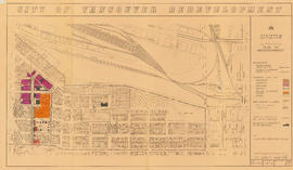
City of Vancouver redevelopment : project 2, area "H" and part of "B" : aerial photograph : boundaries of clearance areas : project 2 (areas 8 and 9)
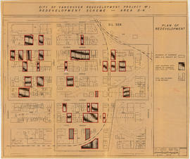
City of Vancouver redevelopment project no. 1 : redevelopment scheme : area D-4
City of Vancouver redevelopment : project 2, area A-2
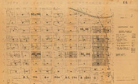
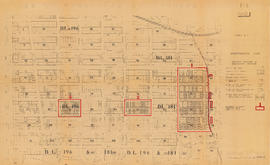
Plan of subdivision of block 120 (explanatory plan 8011), district lot 181
Plan of subdivision of block 120 (explanatory plan 8011), district lot 181
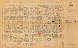
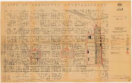
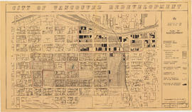
City of Vancouver redevelopment : project 1, area A-1 : identification plan : property included in acquisition program
City of Vancouver redevelopment : project 1, area A-1 : identification plan : property included in acquisition program (status of property acquisition and demolition)
City of Vancouver redevelopment : project 1, area A-1 : identification plan : property included in acquisition program
City of Vancouver redevelopment : project 1, area A-1 : identification plan : property included in acquisition program
City of Vancouver redevelopment : project 1, area A-1 : City-owned land and buildings to be retained
City of Vancouver redevelopment : project 1, area A-1 : detailed plan of redevelopment
City of Vancouver redevelopment : project 1, area A-1 : detailed plan of redevelopment
City of Vancouver redevelopment : project 1, area A-1.1 : existing and proposed utilities
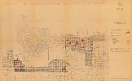
City of Vancouver redevelopment : project 1 : generalized plan of redevelopment
City of Vancouver redevelopment : project 1 : generalized plan of redevelopment
City of Vancouver redevelopment : project 1 : plan showing redevelopment of area A-1.1 as proposed
City of Vancouver redevelopment : project 1, area D-1 : identification plan : property included in acquisition program (status of property acquisition and demolition)
City of Vancouver redevelopment : project 2, area "H" and part of "B" : alternative plan of redevelopment
City of Vancouver redevelopment : project 2, area "H" and part of "B" : identification plan
City of Vancouver redevelopment : project 2, part of area "A" : identification plan
City of Vancouver redevelopment : project 2, area A-2 : plan of redevelopment
Strathcona rehabilitation program
Potential redevelopment areas
Urban renewal scheme 3 : Strathcona I & portion of Highway 6 : condition of residential buildings
Urban renewal scheme 3 : Strathcona I & portion of Highway 6 : condition of non-residential buildings
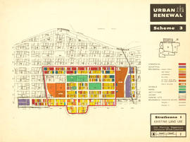
Urban renewal scheme 3 : Strathcona I : existing land use
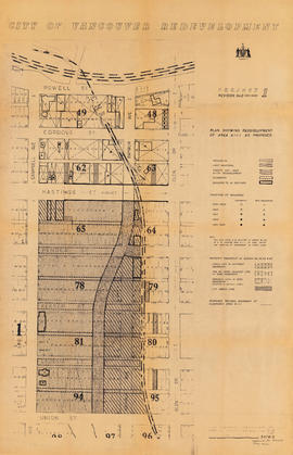
Project 2, area "h" and part of "b" : proposed property acquisitions project 2
Project 2 : generalized plan of redevelopment
Project 2, part of area "a" : aerial photograph
Project 2, part of area "a" : condition of buildings
Project 2, part of area "a" : pavements, curbs and sidewalks
Project 2, part of area "a" : existing utilities, water and sewer
Project 2, part of area "a" : existing utilities, gas, electricity and telephone
Project 2, part of area "a" : plan of redevelopment
Project 2, part of area "a" : utility diversions and rearrangements
Project 2, part of area "a" : identification plan
Redevelopment Project No. 2 Plan No. 1
Part of area "a" : plan of redevelopment, Strathcona
Project 2 area "h" and part of "b" : identification plan
Project 2 : generalized plan of redevelopment
Project 2, part of area "a" : aerial photograph
Project 2, part of area "a" : condition of buildings
Project 2, part of area "a" : pavements, curbs and sidewalks
Project 2, part of area "a" : existing utilities, water and sewer
Project 2, part of area "a" : existing gas, electricity and telephone
Project 2, part of area "a" : plan of redevelopment
Project 2, part of area "a" : identification plan
Project 2, area "h" and part of "b" : condition of buildings
Project 2, area "h" and part of "b" : pavements, curbs and sidewalks
Project 2, area "h" and part of "b" : existing utilities, water and sewer