- COV-S305--
- File
- [1962?]-Jul. 1971
Part of City of Vancouver fonds
File consists of identification plans and redevelopment plans for project 2.
10 results with digital objects Show results with digital objects
Part of City of Vancouver fonds
File consists of identification plans and redevelopment plans for project 2.
Part of City of Vancouver fonds
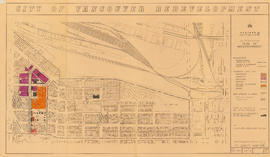
Item is a map showing boundaries of redevelopment and clearance areas, proposed land use, new streets and lanes, sites not to be acquired, and buildings to be retained in project 2. Map has been annotated with colour indicating land use and a proposed widening of Scotia Street. Base map shows building outlines and topographic contour lines, and covers the area bounded by Main Street, Clark Drive, Terminal Avenue, and Broadway

City of Vancouver redevelopment : project 2, area "H" and part of "B" : identification plan
Part of City of Vancouver fonds
Item is a map showing boundaries of clearance areas and ownership of property included in the acquisition program. Map has been annotated to show a possible amendment to the clearance area boundaries and a proposed widening of Scotia Street. Base map shows building outlines and topographic contour lines, and covers the area bounded by Main Street, Clark Drive, Terminal Avenue, and Broadway

Part of City of Vancouver fonds
Item is a map annotated to show the boundaries of Project no. 2 areas 8 and 9. Area 8 corresponds roughly to the area bounded by Scotia Street, Brunswick Street, 2nd Avenue, and 8th Avenue. Area 9 corresponds roughly to the area bounded by Guelph Street, Fraser Street, 5th Avenue, and 7th Avenue. Base map is a reproduction of an aerial photograph showing the area bounded by Main Street, Clark Drive, Terminal Avenue, and Broadway.

Project 2, area "h" and part of "b" : condition of buildings
Part of City of Vancouver fonds
Item is a map showing the condition of buildings (ranging from very good to very poor), the boundaries of redevelopment for areas "b" and "h" and the boundaries of project clearance for areas 8 and 9 for redevelopment proct 2.

Project 2, area "h" and part of "b" : pavements, curbs and sidewalks
Part of City of Vancouver fonds
Item is a map showing the types of pavement, the curbs and gutters, the sidewalks, the boundaries of redevelopment for areas "b" and "h" and the boundaries of project clearance for areas 8 and 9 for redevelopment project 2.

Project 2, area "h" and part of "b" : existing utilities, water and sewer
Part of City of Vancouver fonds
Item is a map showing the water lines, the sewer lines, the direction of sewer flow, the boundaries of redevelopment for areas "b" and "h" and the boundaries of project clearance for areas 8 and 9 in redevelopment project 2.

Project 2, area "h" and part of "b" : existing gas, electricity and telephone
Part of City of Vancouver fonds
Item is a map showing the gas lines, the electricity lines, the telephone lines, the boundaries of redevelopment for areas "b" and "h" and the boundaries of project clearance for areas 8 and 9 in redevelopment project 2.

Project 2, area "h" and part of "b" : plan of redevelopment
Part of City of Vancouver fonds
Item is a map showing boundaries of redevelopment areas "b" and "h", boundaries of project 2 clearance for areas 8 and 9, in project 2, proposed land use, new streets and lanes, sites in project 2 not to be acquired and buildings in project 2 to be retained.

Project 2, area "h" and part of "b" : condition of buildings
Part of City of Vancouver fonds
Item is a map showing the conditions of buildings (ranging from very good to very poor) in area "a" and part of area "b" in project 2. The map has been annotated to highlite part of the boundary around sub-area 9, as well as the southern portion of the sub-area. The significance of these annotations is not known.

Project 2 area "h" and part of "b" : identification plan
Part of City of Vancouver fonds
Item is a map created to show the boundaries of redevelopment areas "b" and "h" in Project 2 and Project 2 clearance areas 8 & 9. The map also shows City-owned property, Adjacent lots in same ownership, as well as property, streets and lanes be acquired for the project. The portion of the City depicted in the map is the area between Main Street and Clark Drive and between Evans Avenue and 10th Avenue (D.L.200, D.L. 264A, D.L. 301, and D.L. 2037).
Projects no. 1 and 2 maps and plans
Part of City of Vancouver fonds
File consists primarily of maps pertaining to redevelopment project 1, areas A and D, but also contains two maps from project 2. Maps include identification plans of property to be acquired; boundaries of clearance areas; general and detailed redevelopment plans; and maps showing the layout of existing and proposed utilities.