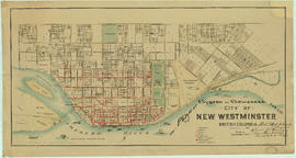
Vancouver, British Columbia : [urban analysis maps]
Hydro electric surveys. Plan showing location of water powers investigated by City of Vancouver
Hydro electric surveys. Plan showing location of water powers investigated by City of Vancouver
Cheakamus power survey for City of Vancouver 1930-1931 : plan showing proposed development from Garibaldi Lake to Daisy Lake : sheet no. 10 to accompany report of E.A. Cleveland dated November 30th 1931
Cheakamus power survey for City of Vancouver, 1930-1931 : plan showing topography southward along a line from Cheakamus River near Mile 34, P.G.E. Rly. : sheet no. 9 to accompany report of E.A. Cleveland dated November 30th 1931
Cheakamus power survey for City of Vancouver, 1930-1931 : topographical plan from Alpha Lake to Cheakamus River, above Mile 34, P.G.E. Rly. : sheet no. 8 to accompany report of E.A. Cleveland dated November 30th 1931
Cheakamus power survey for City of Vancouver, 1930-1931 : plan showing proposed diversion works near Mile 19 - P.G.E. Rly., detail sheet : sheet no. 7 to accompany report of E.A. Cleveland dated November 30th 1931
Cheakamus power survey for City of Vancouver, 1930-1931 : plan showing proposed development near Mile 19 - P.G.E. Rly. : sheet no. 6 to accompany report of E.A. Cleveland dated November 30th 1931
Cheakamus power survey for City of Vancouver, 1930-1931 : proposed storage reservoir at Daisy Lake : sheet no. 5 to accompany report of E.A. Cleveland dated November 30th 1931
Cheakamus power survey for City of Vancouver, 1930-1931 : plan showing proposed development near McGuire and Brandywine : sheet no. 4 to accompany report of E.A. Cleveland dated November 30th 1931
Cheakamus power survey for City of Vancouver, 1930-1931 : plan showing proposed development at Cheakamus Lake : sheet no. 3 to accompany report of E.A. Cleveland dated November 30th 1931
Cheakamus power survey for City of Vancouver, 1930-1931 : mass curves showing Cheakamus River discharge : sheet no. 2 to accompany report of E.A. Cleveland dated November 30th 1931
Cheakamus power survey for City of Vancouver, 1930-1931 general plan and profile : sheet no. 1 [Garibaldi Lake to Cheakamus Lake] to accompany report of E.A. Cleveland dated November 30th 1931
Cheakamus power survey for City of Vancouver, 1930-1931 : general plan & profile : sheet no. 1 [Garibaldi Lake to Cheakamus Lake] to accompany report of E.A. Cleveland dated November 30th 1931
Cheakamus power survey : copy of portion of plan no. 11 accompanying report by E.A. Cleveland
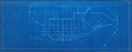
Redevelopment project no. 2 area a-6, including existing blocks 72, 73, 87, 88, D.L. 196 : site plan and general location of utilities plan no. 3
Project 2, part of area "a" : utility diversions and rearrangements
Project 2, part of area "a" : existing utilities, gas, electricity and telephone
Project 2, part of area "a" : existing utilities, water and sewer
City of Vancouver redevelopment : project 1, area A-1.1 : existing and proposed utilities
Plan of subdivision of block 120 (explanatory plan 8011), district lot 181
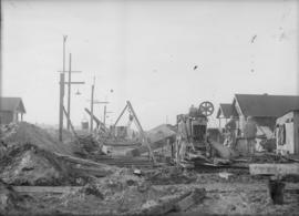
Sewer construction on Venables Street east of Penticton Street
Sewer tunnel with brick siding
Sewer construction, possibly on Venables Street
Men standing at sewer outfall
Sewer construction, possibly on Venables Street
Man squatting in sewer tunnel
Sewer construction on Venables Street east of Penticton Street
Sewer construction on Venables Street east of Penticton Street


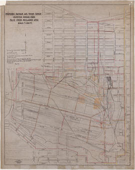


![False Creek development : san [sanitary] sewers tentative layout](/uploads/r/null/c/a/ca111eaa497f59a66ecdad4c91bfb2238f21efb21b91a1172f460ef16667055f/4da08847-7457-4d4c-8938-e4c6c1dc50c3-MAP692_142.jpg)