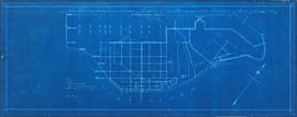
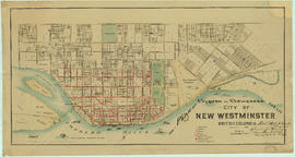
Showing 94 results

Archival description
Public utilities Image With digital objects
Print preview View:

Capilano and Seymour water sheds

Item is a map showing Capilano and Seymour water sheds, reservoirs, pipelines, lot numbers and major roads in the area from Howe Sound to Port Moody and Britannia to Delta. The item includes information about the drainage area, annual precipitation and annual runoff associated with the Capilano and Seymour water sheds.

Hydro electric surveys. Plan showing location of water powers investigated by City of Vancouver

Item is a map which functions as a visual index to the locations of various hydro electric surveys carried out by the City of Vancouver along the following rivers: Squamish River, Cheakamus River, Green River, Lillooet River, Eagle River, Indian River, Pitt River, Chehalis River, Harrison River, Chilliwack River, the Fraser and Thompson Rivers, and Bridge River. The map lists the names of the surveyors responsible and the areas covered by each survey. Annotations include the locations and the dates of use of "gauging stations established" and "city gauging stations still in use."

Results 1 to 50 of 94