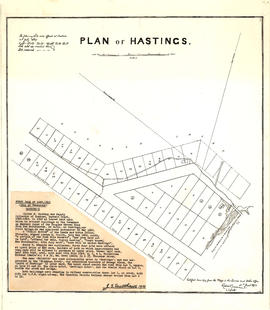
Showing 390 results

Archival description
Land subdivision--Vancouver (B.C.)
Print preview View:

364 results with digital objects Show results with digital objects

Plan of Hastings

Map is a negative photostatic copy of a plan of lots offered for auction in Hastings on 10th July 1869, indicating which lots were sold and which lots were reserved. Plan also shows the locations of government buildings, a church, a hospital, Oliver M. Hocking's house and stable, the road from New Westminster to Burrard Inlet, Mae N. (Broughton), and [bearing] to Moody's Mill. This map does not include the typed note by J.S. Matthews, 1933, titled "First Sale of Lots, 1869 (City of Vancouver), Hocking's." The map was certified by Robert Beaver, C.C.L&W, as a true copy from the map in the Lands and Works Office, 21st June 1873. Also included with the map are drafts of the text by Major Matthews.

Plan of Hastings

Map is a photostatic copy of a plan of lots offered for auction in Hastings on 10th July, 1869, indicating which lots were sold and which lots were reserved. Plan also shows the locations of government buildings, a church, a hospital, Oliver M. Hocking's house and stable, the road from New Westminster to Burrard Inlet, Mae N. (Broughton), and [bearing] to Moody's Mill. Includes a note by J.S. Matthews, 1933, titled "First Sale of Lots, 1869 (City of Vancouver), Hocking's." The map was certified by Robert Beaver, C.C.L&W, as a true copy from the map in the Lands and Works Office, 21st June 1873. Also included with the map are drafts of the text by Major Matthews.

Plan of Hastings

Map is a negative photostatic copy of a plan of lots offered for auction in Hastings on 10th July 1869, indicating which lots were sold and which lots were reserved. Plan also shows the locations of government buildings, a church, a hospital, Oliver M. Hocking's house and stable, the road from New Westminster to Burrard Inlet, Mae N. (Broughton), and [bearing] to Moody's Mill. Includes a note by J.S. Matthews, 1933, titled "First Sale of Lots, 1869 (City of Vancouver), Hocking's." The original map was certified by Robert Beaver, C.C.L&W, as a true copy from the map in the Lands and Works Office, 21st June 1873. Also included with the map are drafts of the text by Major Matthews.

Plan of Hastings

Map is a photostatic copy of a plan of lots offered for auction in Hastings on 10th July 1869, indicating which lots were sold and which lots were reserved. Plan also shows the locations of government buildings, a church, a hospital, Oliver M. Hocking's house and stable, the road from New Westminster to Burrard Inlet, Mae N. (Broughton), and [bearing] to Moody's Mill. This map does not include the typed note by J.S. Matthews, 1933, titled "First Sale of Lots, 1869 (City of Vancouver), Hocking's." The map was certified by Robert Beaver, C.C.L&W, as a true copy from the map in the Lands and Works Office, 21st June 1873. Also included with the map are drafts of the text by Major Matthews.

Plan of Hastings

Map is a plan of lots offered for auction in Hastings on 10th July 1869, indicating which lots were sold and which lots were reserved. Plan also shows the locations of government buildings, a church, a hospital, Oliver M. Hocking's house and stable, the road from New Westminster to Burrard Inlet, Mae N. (Broughton), and [bearing] to Moody's Mill. Pasted onto the front of the map is a typed note by J.S. Matthews, 1933, titled "First Sale of Lots, 1869 (City of Vancouver), Hocking's." The map was certified by Robert Beaver, C.C.L&W, as a true copy from the map in the Lands and Works Office, 21st June 1873. Also included with the map are drafts of the text by Major Matthews.

Plan of Hastings

Map is a photostatic copy of MAP 1037.01, showing a plan of lots offered for auction in Hastings on 10th July 1869 and indicating which lots were sold and which lots were reserved. Plan also shows the locations of government buildings, a church, a hospital, Oliver M. Hocking's house and stable, the road from New Westminster to Burrard Inlet, Mae N. (Broughton), and [bearing] to Moody's Mill. This map does not include the typed note by J.S. Matthews, 1933, titled "First Sale of Lots, 1869 (City of Vancouver), Hocking's." The map was certified by Robert Beaver, C.C.L&W, as a true copy from the map in the Lands and Works Office, 21st June 1873. Also included with the map are drafts of the text by Major Matthews.

Map of portion New Westminster District

Item is a heavily-amended copy of a map illustrating intended land settlement and subdivision in 1877 in the future sites of Vancouver, Burnaby and the North Shore, from an area bordering on English Bay to an area bordering on North Arm. Also shown are bodies of water, Hastings & Granville Road, and the settlements of Hastings and Granville. Annotations by J.S. Matthews in 1954 made on the copy are tracings in white pen and darkening the background to improve the copy.

Map of portion New Westminster District

Item is an annotated tracing of a map showing the future sites of Vancouver, Burnaby and the North Shore from an area bordering on English Bay to an area bordering on North Arm. Traced over by J.S. Matthews in 1954, it illustrates intended land settlement and subdivision in 1877. Also shown are bodies of water, Hastings & Granville Road, and the settlements of Hastings and Granville. Annotations are an introductory note by Matthews in August 1954 titled "Before Greater Vancouver." Enclosed with the map are four letters between J.S. Matthews and W.H. Hutchinson, Chief of the Geographic Division of the B.C. Survey and Mapping Branch of the Department of Lands and Forests, in 1954 concerning the map's provenance and Matthew's efforts to increase the legibility of copies of the original map.

False Creek Indian Reserve, Burrard Inlet, B.C. : compiled from plans of record in the Dept. [Department] of Indian Affairs

Map is a plan of the Kitsilano Point area showing the area currently known as Kitsilano Beach and Vanier Park, and streets and blocks between Maple Street and Centre Street (Granville Street) and First Avenue to Third Avenue. The plan shows in detail the land designated as the Kitsilano Indian Reserve, including the original reserve as constituted prior to Confederation, the addition made by the Joint Commission on 15th June 1877, and land leased to Harrison Mills T. and T. Co. Map also shows the location of Canadian Pacific Railway land, the Vancouver and Lulu Island Railroad, Rat Portage Lumber Company, Tait's Mill, the Third Avenue Bridge and bathing beach. Annotations in ink indicate the location of Sam Greer's house and garden and nearby spring on what is now known as Kitsilano Beach. A note made on the front of the map by J.S. Matthews in 1930 reads "This blueprint was given me about 1928 by Mrs. J.Z. Hall, dau[ghter] of Sam Greer, and had evidently been attached to a letter from Hon. H.H. Stevens, M.P. to Mr. Greer, dated Ottawa, May 15, 1923 with enclosure from Dr. Scott Indian Office, Ottawa, 9th May 1923. The notation "House" and "Garden" were, when first received by me, on pencil, rudely written, perhaps by Mr. Greer himself (quite and most likely). The marks were inked in with Indian ink by me."

Corporation of Point Grey : topographical plan of ABCDE D.L. 317 and HIJK D.L. 318 : Marine Drive & Vancouver & Lulu Railway to Fraser River between Angus St. [Drive] & Milton St

Item is a topographical plan of Point Grey showing the area from Angus Drive to Granville Street and 71st Avenue to the Fraser River, including property in D.L. 317 and D.L. 318. Plan shows the locations of the Vancouver and Lulu Island Railway, as well as ponds, dams, barns, houses and offices.

Plan of district lot boundaries, City of Vancouver, B.C.

Item is a map of Vancouver showing district lot boundaries.

The map identifies First Nations reserves, the University Endowment Lands, Stanley Park, Old Granville Townsite and Hastings Townsite. On the verso of the map is a legend indicating the colours used on the maps in this file to define areas of tax sale property for sale, no water, street widening - drainage, replotting, reserved school, reserved park, sundry, capital assets (except schools and parks), schools, and parks.

Vancouver (B.C.). Office of the City Engineer

Sheet 7 : Clark Drive to Slocan Street and Seventh Avenue to Eighteenth Avenue

Item is a section showing the area from Clark Drive to Slocan Street and Seventh Avenue to Eighteenth Avenue. Includes streets and roads, blocks, lots, legal descriptions, railways, parks and schools. Some annotations have been made in green ink.

Vancouver (B.C.). Office of the City Engineer

Sheet 6 : Knight Street to Slocan Street and Eighteenth Avenue to Twenty-ninth Avenue

Item is a section showing the area from Knight Street to Slocan Street and Eighteenth Avenue to Twenty-ninth Avenue. Includes streets and roads, blocks, lots, legal descriptions, railways, parks and schools. Some annotations have been made in pencil.

Vancouver (B.C.). Office of the City Engineer

Sheet 12 : Ontario Street to Clark Drive and Keefer Street to Second Avenue

Item is a section showing the area from Ontario Street to Clark Drive and Keefer Street to Second Avenue. Includes streets, roads, blocks, lots, legal descriptions, railways, parks and schools. Includes Terminal Avenue and land used by the Great Northern Railway and the Canadian National Railway.

Vancouver (B.C.). Office of the City Engineer

Sheet 4 : Prince Edward Street to Bruce Street and King Edward Avenue to Thirty-sixth Avenue

Item is a section showing the area from Prince Edward Street to Bruce Street and King Edward Avenue to Thirty-sixth Avenue. Map shows streets, roads, blocks, lots and legal descriptions, and the locations of parks, schools and Mountainview Cemetery.

Vancouver (B.C.). Office of the City Engineer

Sheet 1: Slocan Street to Boundary Road and Triumph Street to Burrard Inlet

Item is a section showing the area bound by Slocan Street, Boundary Road, Triumph Street and the waterfront. Includes streets, roads, railways, blocks, lots, legal descriptions, quit claims, leases, parks and businesses along the waterfront.

Vancouver (B.C.). Office of the City Engineer

Sheet 19 : Maple Street to Richards Street and Drake Street to Third Avenue

Item is a section showing Maple Street to Richards Street and Drake Street to Third Avenue. Includes streets, roads, blocks, lots, legal descriptions, parks, schools, the Burrard and Granville Street Bridges, C.P.R. right-of-ways, the Squamish Band reserve, C.P.R. leases and property, and government reserve. Map includes Granville Island.

Vancouver (B.C.). Office of the City Engineer

Sheet S.V. 3 : Cambie Street to St. George Street and Twenty-seventh Avenue to Thirty-eighth Avenue

Item is a section showing the area from Cambie Street to St. George Street and Twenty-seventh Avenue to Thirty-eighth Avenue. Map shows streets, roads, blocks, lots and legal descriptions and the locations of parks, schools, reservoirs and Mountainview Cemetery.

Vancouver (B.C.). Office of the City Engineer

Sheet 5 : Dumfries Street to Fairmont Street and Twenty-seventh Avenue to Thirty-seventh Avenue

Item is a section showing the area from Dumfries Street to Fairmont Street and Twenty-seventh Avenue to Thirty-seventh Avenue. Includes streets, roads, blocks, lots, legal descriptions, parks, railway lines and schools.

Vancouver (B.C.). Office of the City Engineer

Sheet 8 : Prince Edward Street to Bruce Street and Thirty-fifth Avenue to Forty-seventh Avenue

Item is a section showing the area from Prince Edward Street to Bruce Street and Thirty-fifth Avenue to Forty-seventh Avenue. Includes streets, roads, blocks, lots, legal descriptions, and cemeteries, parks and schools.

Vancouver (B.C.). Office of the City Engineer

Sheet 9 : Clark Drive to Slocan Street and Triumph Street to Charles Street

Item is a section showing the area from Clark Drive to Slocan Street and Triumph Street to Charles Street. Includes streets and roads, blocks, lots, legal descriptions, railways, parks, schools and drill hall. The Town of Hastings is indicated on the map.

Vancouver (B.C.). Office of the City Engineer

Sheet 16 : Maple Street to Oak Street and False Creek to Sixteenth Avenue

Item is a sectional map of the "Old City" of Vancouver showing Maple Street to Oak Street and False Creek to Sixteenth Avenue. Includes streets and roads, blocks, lots, legal descriptions, railways, schools and parks. Indicates crown land leased to the C.P.R. and other bodies.

Vancouver (B.C.). Office of the City Engineer

False Creek Indian Reserve, Burrard Inlet, B.C.

Map is a plan of Kitsilano Point showing the area currently known as Kitsilano Beach and Vanier Park. The map shows in detail the land designated as the Kitsilano Indian Reserve, including the location of the First Nations village on False Creek and the older village of Snauq. Indicated are the boundaries of the original reserve as constituted prior to Confederation, and the addition made by the Joint Commission on 15th June 1877. The map shows the location of First Nations homes and their owners as well as orchards, hops growing area, and cemetery; a legend on the right side of the map provides further explanation. Map also shows the location of the Canadian Pacific right of way, Tait's Mill, the Third Avenue Bridge, Sam Greer's house and garden on what is now known as Kitsilano Beach, as well as creeks and other physical characteristics of the land.

Sheet 8 : McLean Drive to Slocan Street and William Street to Seventh Avenue

Item is a section showing the area from McLean Drive to Slocan Street and William Street to Seventh Avenue. Includes streets and roads, blocks, lots, legal descriptions, railways, parks, schools and some businesses. Map is hand coloured to show tax sale property for sale, property with no water, street widening and drainage, replotting, reserved land for schools, reserved land for parks, sundry land, capital assets not including schools and parks, schools, and parks, as applicable. Some annotations have been made in pencil.

Vancouver (B.C.). Office of the City Engineer

Sheet 8 : McLean Drive to Slocan Street and William Street to Seventh Avenue

Item is a section showing the area from McLean Drive to Slocan Street and William Street to Seventh Avenue. Includes streets and roads, blocks, lots, legal descriptions, railways, parks, schools and some businesses.

Vancouver (B.C.). Office of the City Engineer

Sheet 10 : Clark Drive to Slocan Street and Burrard Inlet to Triumph Street

Item is a section showing the area from Clark Drive to Slocan Street and aterfront to Triumph Street. Includes streets and roads, blocks, lots, legal descriptions, railways, parks, boys' detention home and businesses along the waterfront. The Town of Hastings is indicated on the map. Map is hand coloured to show tax sale property for sale, property with no water, street widening and drainage, replotting, reserved land for schools, reserved land for parks, sundry land, capital assets not including schools and parks, schools, and parks, as applicable.

Vancouver (B.C.). Office of the City Engineer

Sheet 10 : Clark Drive to Slocan Street and waterfront to Triumph Street

Item is a section showing the area from Clark Drive to Slocan Street and waterfront to Triumph Street. Includes streets and roads, blocks, lots, legal descriptions, railways, parks, boys' detention home and businesses along the waterfront. The Town of Hastings is indicated on the map.

Vancouver (B.C.). Office of the City Engineer

Sheet 11 : Carrall Street to Clark Drive and waterfront to Keefer Street

Item is a section showing the area from Carrall Street to Clark Drive and waterfront to Keefer Street. Includes streets and roads, blocks, lots, legal descriptions, railways, parks, schools, freight sheds, warehouses, piers and businesses along the waterfront.Map is hand coloured to show tax sale property for sale, property with no water, street widening and drainage, replotting, reserved land for schools, reserved land for parks, sundry land, capital assets not including schools and parks, schools, and parks, as applicable.

Vancouver (B.C.). Office of the City Engineer

Sheet 11 : Carrall Street to Clark Drive and waterfront to Keefer Street

Item is a section showing the area from Carrall Street to Clark Drive and waterfront to Keefer Street. Includes streets and roads, blocks, lots, legal descriptions, railways, parks, schools, freight sheds, warehouses, piers and businesses along the waterfront.

Vancouver (B.C.). Office of the City Engineer

Sheet 13 : Ontario Street to Clark Drive and First Avenue to Sixteenth Avenue

Item is a section showing the area from Ontario Street to Clark Drive and First Avenue to Sixteenth Avenue. Includes streets, roads, blocks, lots, legal descriptions, railways, parks and schools. Includes B.C. Electric Railway car barns.

Vancouver (B.C.). Office of the City Engineer

Sheet 13 : Ontario Street to Clark Drive and First Avenue to Sixteenth Avenue

Item is a section showing the area from Ontario Street to Clark Drive and First Avenue to Sixteenth Avenue. Includes streets, roads, blocks, lots, legal descriptions, railways, parks and schools. Includes B.C. Electric Railway car barns. Map is hand coloured to show tax sale property for sale, property with no water, street widening and drainage, replotting, reserved land for schools, reserved land for parks, sundry land, capital assets not including schools and parks, schools, and parks. Annotations in pencil.

Vancouver (B.C.). Office of the City Engineer

Results 1 to 50 of 390