
Plan of Hastings

Plan of Hastings

Plan of Hastings

Plan of Hastings
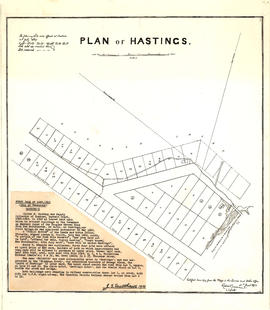
Plan of Hastings
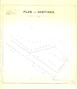
Plan of Hastings

Map of portion New Westminster District

Map of portion New Westminster District
![Plan shewing [showing] division of property belonging to Major C.W. Hill](/uploads/r/null/0/f/0f72067c788c91a520f5055e8b1241e0ee99f2c20c434b03eca0174baea425dc/d22e8a25-814f-4266-99a4-24c639764600-MAP787_142.jpg)
Plan shewing [showing] division of property belonging to Major C.W. Hill

Plan of district lot boundaries, City of Vancouver, B.C.

Sheet 4 : Slocan Street to Boundary Road and Seventh Avenue to Seventeenth Avenue

Sheet 7 : Clark Drive to Slocan Street and Seventh Avenue to Eighteenth Avenue

Sheet 1 : Cambie Street to Carolina Street and Sixteenth Avenue to Twenty-eighth Avenue

Sheet 7 : Cambie Street to St. George Street and Thirty-seventh Avenue to Forty-eighth Avenue

Sheet 9 : Fleming Street to Carlton Street and Thirty-seventh Avenue to Forty-eighth Avenue

Sheet 11 : Cambie Street to St. George Street and Forty-seventh Avenue to Fifty-eighth Avenue

Sheet 18 : Vivian Street to Boundary Road and Sixty-fifth Avenue to Fraser River

Sheet 13 : Fleming Street to Carlton Street and Forty-seventh Avenue to Fifty-ninth Avenue

Sheet 6 : Knight Street to Slocan Street and Eighteenth Avenue to Twenty-ninth Avenue

Sheet 12 : Ontario Street to Clark Drive and Keefer Street to Second Avenue

Sheet 12 : Prince Edward Street to Bruce Street and Forty-seventh Avenue to Fifty-eighth Avenue

Sheet 4 : Prince Edward Street to Bruce Street and King Edward Avenue to Thirty-sixth Avenue

Sheet 1: Slocan Street to Boundary Road and Triumph Street to Burrard Inlet

Sheet 3 : Slocan Street to Boundary Road and Seventh Avenue to Charles Street

Sheet 19 : Maple Street to Richards Street and Drake Street to Third Avenue

Sheet 16 : St. George Street to Argyle Street and Fifty-eighth Avenue to Fraser River

Sheet S.V. 3 : Cambie Street to St. George Street and Twenty-seventh Avenue to Thirty-eighth Avenue

Sheet 5 : Dumfries Street to Fairmont Street and Twenty-seventh Avenue to Thirty-seventh Avenue

Sheet 8 : Prince Edward Street to Bruce Street and Thirty-fifth Avenue to Forty-seventh Avenue

Sheet 10 : Carlton Street to Boundary Road and Fortieth Avenue to Fiftieth Avenue

Sheet 9 : Clark Drive to Slocan Street and Triumph Street to Charles Street

Sheet 18 : Trutch Street to Maple Street and English Bay to Third Avenue

Sheet 14 : Ash Street to St. George Street and Marine Drive to Fraser River

Sheet 15 : Ash Street to St. George Street and Fifty-eighth Avenue to Marine Drive

Sheet 17 : Argyle Street to Vivian Street and Sixty-second Avenue to Kent Street

Sheet Q : Churchill Street to Cambie Street and Thirty-eighth Street to Forty-ninth Avenue

Sheet 6 : Craddock Street to Boundary Road and Twenty-ninth Avenue to Fortieth Avenue

Sheet 16 : Maple Street to Oak Street and False Creek to Sixteenth Avenue

Plan of district lot boundaries, City of Vancouver, B.C.

Sheet 8 : McLean Drive to Slocan Street and William Street to Seventh Avenue

Sheet 8 : McLean Drive to Slocan Street and William Street to Seventh Avenue

Sheet 10 : Clark Drive to Slocan Street and Burrard Inlet to Triumph Street

Sheet 10 : Clark Drive to Slocan Street and waterfront to Triumph Street

Sheet 11 : Carrall Street to Clark Drive and waterfront to Keefer Street

Sheet 11 : Carrall Street to Clark Drive and waterfront to Keefer Street

Sheet 13 : Ontario Street to Clark Drive and First Avenue to Sixteenth Avenue

Sheet 13 : Ontario Street to Clark Drive and First Avenue to Sixteenth Avenue

Sheet 14 : Main Street to Knight Street and Fifteenth Avenue to King Edward Street
Sheet 14 : Main Street to Knight Street and Fifteenth Avenue to King Edward Street
![Plan of district lot boundaries, City of Vancouver, B.C. [index map]](/uploads/r/null/9/4/9469805f0ad98fa8c476e2fa1bd641a165448bbfe6840da2ca337894637001a4/9199ff56-1884-4c1f-8d1c-1a513de71a3d-MAP779_142.jpg)
Plan of district lot boundaries, City of Vancouver, B.C. [index map]