Print preview Close
Showing 312 results
Archival description293 results with digital objects Show results with digital objects
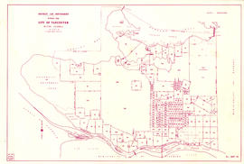
![City of Vancouver, British Columbia [index map]](/uploads/r/null/d/4/d4fc7ef393680c6515927aa960de863e6fd9e846c3fac12499691549673dc4b7/eed36b0b-2e63-48f2-a7ee-02ed3de937b9-MAP682_142.jpg)
City of Vancouver, British Columbia [index map]
City of Vancouver, British Columbia [sectional map]
City of Vancouver, British Columbia [sectional map]
City of Vancouver, Vancouver, British Columbia : sectional maps
City of Vancouver, Vancouver, British Columbia : sectional maps
City of Vancouver, Vancouver, British Columbia : sectional maps
City of Vancouver, Vancouver, British Columbia : sectional maps
City of Vancouver, Vancouver, British Columbia : sectional maps (printed 1970)
City of Vancouver, Vancouver, British Columbia : sectional maps (printed 1970)
Corporation of Point Grey : topographical plan of ABCDE D.L. 317 and HIJK D.L. 318 : Marine Drive & Vancouver & Lulu Railway to Fraser River between Angus St. [Drive] & Milton St
Corporation of Point Grey : topographical plan of ABCDE D.L. 317 and HIJK D.L. 318 : Marine Drive & Vancouver & Lulu Railway to Fraser River between Angus St. [Drive] & Milton St
District lot boundaries with the City of Vancouver, British Columbia

District lot boundaries with the City of Vancouver, British Columbia, D.L. map 40
False Creek Indian Reserve, Burrard Inlet, B.C. : compiled from plans of record in the Dept. [Department] of Indian Affairs
False Creek Indian Reserve, Burrard Inlet, B.C. : compiled from plans of record in the Dept. [Department] of Indian Affairs

Index to 400 ft. scale section maps, City of Vancouver, British Columbia

Index to 400 ft. scale section maps, City of Vancouver, British Columbia, index map 40
![Map of City of Vancouver, British Columbia [index map]](/uploads/r/null/b/4/b4070d13913e90841a24384f7c94ab9f22595ff9bde62429edb46fd5ed60a75a/f4bb676f-1639-4811-82bf-2a0d4defd87e-MAP779_142.jpg)
Map of City of Vancouver, British Columbia [index map]

Map of portion New Westminster District

Plan of district lot boundaries, City of Vancouver, B.C.
![Plan of district lot boundaries, City of Vancouver, B.C. [index map]](/uploads/r/null/9/4/9469805f0ad98fa8c476e2fa1bd641a165448bbfe6840da2ca337894637001a4/9199ff56-1884-4c1f-8d1c-1a513de71a3d-MAP779_142.jpg)
Plan of district lot boundaries, City of Vancouver, B.C. [index map]
![Plan shewing [showing] division of property belonging to Major C.W. Hill](/uploads/r/null/0/f/0f72067c788c91a520f5055e8b1241e0ee99f2c20c434b03eca0174baea425dc/d22e8a25-814f-4266-99a4-24c639764600-MAP787_142.jpg)
Plan shewing [showing] division of property belonging to Major C.W. Hill

Sheet 1 : Cambie Street to Carolina Street and Sixteenth Avenue to Twenty-eighth Avenue

Sheet 1 : Slocan Street to Boundary Road and Triumph Street to Burrard Inlet

Sheet 1: Slocan Street to Boundary Road and Triumph Street to Burrard Inlet

Sheet 10 : Carlton Street to Boundary Road and Fortieth Avenue to Fiftieth Avenue

Sheet 10 : Clark Drive to Nanaimo Street and Frances Street to Burrard Inlet
![[Sheet 10 : Clark Drive to Nanaimo Street and Frances Street to Burrard Inlet]](/uploads/r/null/b/1/b1095cb557ec54cc1f1894faad721045c1eaa4b11b76e6c08ec0349a9138f078/f41cbf9e-303f-40cd-8ef4-f0699363222c-MAP339_142.jpg)
[Sheet 10 : Clark Drive to Nanaimo Street and Frances Street to Burrard Inlet]

Sheet 10 : Clark Drive to Slocan Street and waterfront to Triumph Street

Sheet 10 : Clark Drive to Slocan Street and waterfront to Triumph Street

Sheet 11 : Cambie Street to St. George Street and Forty-seventh Avenue to Fifty-eighth Avenue

Sheet 11 : Carrall Street to Clark Drive and waterfront to Keefer Street

Sheet 11 : Carrall Street to Clark Drive and waterfront to Keefer Street

Sheet 11 : Wall Street to Rupert Street and McGill Street to Burrard Inlet
![[Sheet 11 : Wall Street to Rupert Street and McGill Street to Burrard Inlet]](/uploads/r/null/e/b/eb84fb8de9ca2e1644a2e39bcbaad5253c563e8716cf25114e675fb7d40365ea/0935fb81-4662-411a-bdfd-c9823c7fb82b-MAP339_142.jpg)
[Sheet 11 : Wall Street to Rupert Street and McGill Street to Burrard Inlet]

Sheet 12 : Prince Edward Street to Bruce Street and Forty-seventh Avenue to Fifty-eighth Avenue

Sheet 12 : Nanaimo Street to Cassiar Street and Pender Street to McGill Street
![[Sheet 12 : Nanaimo Street to Cassiar Street and Pender Street to McGill Street]](/uploads/r/null/6/0/603c1cdc3adb1f0dec963bbd885c378ce1e23c71767cb0b461ef6ccc54807a5a/49483dc1-d90f-4a82-86cd-3c7a09f2ddae-MAP339_142.jpg)
[Sheet 12 : Nanaimo Street to Cassiar Street and Pender Street to McGill Street]

Sheet 12 : Ontario Street to Clark Drive and Keefer Street to Second Avenue

Sheet 12 : Ontario Street to Clark Drive and Keefer Street to Second Avenue

Sheet 13 : Fleming Street to Carlton Street and Forty-seventh Avenue to Fifty-ninth Avenue

Sheet 13 : Ontario Street to Clark Drive and First Avenue to Sixteenth Avenue

Sheet 13 : Ontario Street to Clark Drive and First Avenue to Sixteenth Avenue

Sheet 13 : Rupert Street to Boundary Road and Eton Street to Burrard Inlet
![[Sheet 13 : Rupert Street to Gilmore Avenue and Eton Street to Burrard Inlet]](/uploads/r/null/f/0/f03aaa2671556fb722cf612a9736c0a6b919aff4af5a9dbe048dd93863af5773/30eb2a4c-b404-4552-81da-7461e4aacfaa-MAP339_142.jpg)
[Sheet 13 : Rupert Street to Gilmore Avenue and Eton Street to Burrard Inlet]

Sheet 14 : Ash Street to St. George Street and Marine Drive to Fraser River

Sheet 14 : Cassiar Street to Boundary Road and Pender Street to Eton Street
![[Sheet 14 : Cassiar Street to Carleton Avenue and Pender Street to Eton Street]](/uploads/r/null/a/4/a404347152c9328da5ec443862d19bc937a2199f1ce3cde01729819bfd1272d2/5ec2b15f-3c41-4c16-8567-f00ced74929f-MAP339_142.jpg)
[Sheet 14 : Cassiar Street to Carleton Avenue and Pender Street to Eton Street]

Sheet 14 : Main Street to Knight Street and Fifteenth Avenue to King Edward Street

Sheet 14 : Main Street to Knight Street and Fifteenth Avenue to King Edward Street

Sheet 15 : Ash Street to St. George Street and Fifty-eighth Avenue to Marine Drive

Sheet 15 : Oak Street to Main Street and False Creek to Sixteenth Avenue

Sheet 15 : Oak Street to Main Street and False Creek to Sixteenth Avenue
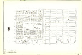
Sheet 15 : Rupert Street to Boundary Road and Kitchener Street to Pender Street
![[Sheet 15 : Rupert Street to Carleton Avenue and Kitchener Street to Pender Street]](/uploads/r/null/b/7/b7b353e0ba4ef92f21d8b4148594896da61b022d62168ec30d592e80b71eb373/6461e269-e3e0-4cad-b202-be701b9eac5b-MAP339_142.jpg)
[Sheet 15 : Rupert Street to Carleton Avenue and Kitchener Street to Pender Street]

Sheet 16 : Maple Street to Oak Street and False Creek to Sixteenth Avenue
Results 1 to 50 of 312