Map is a plan of downtown Vancouver with areas shaded to indicate streets, squares, malls and arcades, in which the movement of vehicles is not permitted at all or is restricted. Although the entire downtown area is shown, shading pertains only to Jervis Street and Main Street and Burrard Inlet and Nelson Street. Note written in the bottom right corner of the map reads "B 1960 Jan., Traffic Plans, small folder."
Item is consists of an architectural drawing showing three stages of development of a proposed pedestrian mall on Granville Street between Georgia Street and Dunsmuir Street. The pedestrian mall includes a sculpture fountain, sidewalk terraces (cafés), children's play area with merry-go-round, fish pool and fountain pool.
Item is a drawing of a proposed pedestrian mall on Granville Street looking south from Dunsmuir Street. Shows pedestrians; the Vancouver Block, Birks Building and Hudson's Bay Building; shops, including Zellers, Raeson Shoes, Saba Brothers and Woolworth's; the Colonial Theatre; and an outdoor café.
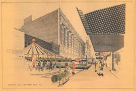
Item is a drawing of a proposed pedestrian mall on Granville Street looking south from about Dunsmuir Street. Shows pedestrians, the Vancouver Block, Birks Building, Hudson's Bay Building, shops, an outdoor café and a merry-go-round.