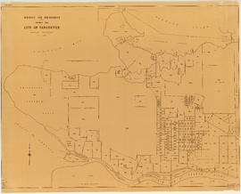
Civic improvements during 1952
- AM1519-: PAM 1952-58
- Item
- 1952
78 results with digital objects Show results with digital objects
Civic improvements during 1952
City Magazine : February-March 1975 : vol. 1 : no. 3
Includes article on Christ Church Cathedral and transfer of density arrangement.
City Magazine : June 1977 : vol. 2 : no. 8
Vancouver content Included in article, "The City Seminar"; as well as a review of Chuck Davis' book, "The Vancouver Book"
City Magazine : March 1977 : vol. 2 : no. 7
Includes article, "Local area planning: the dream and the reality."
City Magazine : January-February 1976: vol. 1 : no. 8
Includes article, "Board of variance shows class bias," by Bob Arnold.
City Magazine : August-September 1975: vol. 1 : nos. 5 and 6 : double issue
Includes articles, "Planners congregate," regarding a planning conference held in Vancouver; "Socialist geographers organize"; and "Neighbourhood improvement: What it means in Calgary, Vancouver and Toronto."
Vancouver, B.C. : zoning diagram
Part of City of Vancouver Archives technical and cartographic drawing collection
Item is a pamphlet with a zoning map of Vancouver on one side and information on Vancouver's history, government, town planning initiatives on the other.
Sectional map of Vancouver showing streets, block and lot outlines, and building perimeters
Part of City publications collection
Item is a sectional map of Vancouver showing streets, block and lot outlines, address block numbers, building perimeters, and street codes according to street codes according to a system adopted by the Engineering Department in the mid-1960s. Building perimeters are not shown on Maps 46, 58-70, 74-75, 78-82, and 90.

Map shows a street plan in Vancouver according to the following: major streets of sufficient width, major streets to be widened, new major street connections, proposed express highways, scenic drives, boulevard drives, parkways and proposed major streets in the University Endowment Lands. The map also indicates the number of traffic lanes in each street.
![Legend [for colour coding land use]](/uploads/r/null/3/1/2/3120f4f71566883ae774f5f08ae6795bc55fcd40d9f4bdd29f8f25dc782e0a9f/89bc7dbc-376d-43ba-bc88-a0fda629d99a-LEG1153_142.jpg)
Legend [for colour coding land use]
Part of City of Vancouver fonds

Properties from Victoria Drive to Nanaimo Street and Burrard Inlet to Triumph Street
Part of City of Vancouver fonds
Item is a map annotated with colour on some properties, though the significance of the colour is unclear. Base map shows streets, legal addresses, and waterfront businesses in the area from Clark Drive to Slocan Street and Burrard Inlet to Powell Street/Triumph Street.

Vancouver British Columbia. Major street plan
Part of City of Vancouver fonds
Vancouver (B.C.). Town Planning Commission
![Map showing City of Vancouver, British Columbia [index map]](/uploads/r/null/a/f/b/afbf0b3832ff37e3af2c10d63547517135bca50be83ddddfcd25914b3c7b8f1d/6903af1e-3c6e-4577-9c0a-0967550524a7-LEG1153_142.jpg)
Map showing City of Vancouver, British Columbia [index map]
Part of City of Vancouver fonds

Plan of District Lot boundaries. City of Vancouver, B.C.
Part of City of Vancouver fonds
Vancouver (B.C.). Office of the City Engineer

Plan of government subdivision at Point Grey, B.C.
Part of City of Vancouver Archives technical and cartographic drawing collection
Item is a sheet which has been excised from the Journal of the Town Planning Institute, December 1925 issue. The sheet consists of two street layout plans and an illustration. The street layout plans show current and proposed revised street layouts for the area of Point Grey bounded by Highbury Street, Eighth Avenue, Imperial Street, and Tenth Avenue. The illustration depicts the view north from the proposed development area.

City of Vancouver, British Columbia
Part of City of Vancouver fonds
Item is a map showing city streets and address block numbers.

The official street name map of the City of Vancouver
Part of City of Vancouver fonds
Item is an annotated version of the Official street name map of the City of Vancouver adopted under By-law no. 4054. Annotations mark out eight areas in the city; four of these marked areas include additional streets not included on the base map.

Proposed system of drainage and sewerage for False Creek and marginal areas
Part of City of Vancouver fonds
Item is a map showing sewers and storm drains in the area from Alexander Street in the north to Seventh Avenue in the south and from Clark Drive in the east to Main Street in the west.
District lot boundaries within the City of Vancouver
Part of City of Vancouver fonds

Part of City of Vancouver Archives technical and cartographic drawing collection
Item is a map showing parade grounds, grand stand and drill hall in the area from Dunsmuir Street to Cambie Street to Georgia Street to Beatty Street. Legend in bottom left corner shows symbols for the following: iron fence, wire screen, goal posts, C.P.R. railway, car tracks, trees and contours. A letter about map from Major Matthews adhered to top right corner. Pencil annotation showing 158th Battalion men's quarters by Major Matthews

Proposed development of Vancouver City Yard, 49th Avenue at Ross Street, South Vancouver
Part of City of Vancouver fonds
Item is a site plan showing existing and proposed storage, accommodation, and work buildings, landscaping, and proposed re-zoning.

Proposed zoning : comprehensive redevelopment areas
Part of City of Vancouver fonds
Item is a map showing proposed zoning for two comprehensive redevelopment areas according to the following district types: residential, commercial (suburban), commercial (medium density), industrial (light) and industrial (heavy). Map also shows the boundaries of the comprehensive redevelopment areas. These two areas lie roughly between Burrard Inlet in the north and 10th Avenue in the south and between Semlin Drive in the east and Burrard Street in the west.

Key map showing proposed areas for partial and comprehensive redevelopment
Part of City of Vancouver fonds
Item is a map showing the boundaries of the redevelopment study area, comprehensive redevelopment areas, limited redevelopment areas and the East End study area. The boundary of the study area lies roughly between Burrard Inlet in the north and 33rd Avenue in the south and between Nanaimo Street in the east and Carnarvon Street in the west.

Part of City of Vancouver fonds
Item is a land survey plan showing locations of survey posts, boundaries between reserve and non-reserve lands, streets, rights of way, and high water marks.

Plan to accompany report on proposed bridge at Marpole across North Arm of Fraser River
Part of City of Vancouver fonds
Item is a map showing five possible locations for a bridge across the North Arm of the Fraser River from the city of Vancouver to either Sea Island or Lulu Island.

Part of City of Vancouver fonds
Item is a map prepared as part of the Harbour Headline project of the False Creek Development Study. Map shows existing, interim and ultimate harbour headlines, existing water areas, ownership boundaries, other property lines and lease boundaries in and around False Creek.

City of Vancouver : land use 1984
Part of City publications collection
Item is a map showing types of residential, commercial, industrial, and recreational land use in Vancouver.

Official Regional Plan : proposed amendments within the City of Vancouver
Part of City publications collection
Item is a map showing proposed amendments to industrial and rural zoning areas.

Part of City publications collection
Item is a map showing proposed commercial and residential zones and the location of an elementary school in the area directly south of Simon Fraser University. Base map shows land use for the area bounded by Willingdon Avenue, North Road, Barnet Road, and the Trans-Canada Highway.

Part of City of Vancouver fonds
Item is a map showing the layout of the proposed fill of Still Creek, existing ground elevations and proposed design elevations. Base map was prepared by the Engineering Department and shows streets, lot numbers, and building footprints.
Georgia Street : the paper for beautiful squares
Flyer concerning a vote for the redevelopment of Georgia and Granville.
Official regional plan of the Lower Mainland planning area

Part of City of Vancouver Archives technical and cartographic drawing collection
Item is a copy of a map of Vancouver which has been hand annotated. The annotations appear to relate to proposed revisions to the street network, including major streets to be widened and new major street connections.
Vancouver (B.C.). Engineer's Office
A composite plan showing Capilano Indian Reserve No. 5 and district lot 5521
Part of City of Vancouver Archives technical and cartographic drawing collection
Item is a map showing a portion of West Vancouver, including D.L. 5521 and the Capilano Indian Reserve No. 5. The annotations denote the location of Humiltschen Park.
West Vancouver (B.C.). Assessment Department

City of Vancouver, British Columbia
Part of City of Vancouver Archives technical and cartographic drawing collection
Item is a map which shows city streets and blocks. The map also notes the location of parks, golf courses and transportation infrastructure.
City of Vancouver, east approach route. Alignment alternatives investigated
Part of City of Vancouver fonds
Item is a map which has been created out of a sepia diazotype copy of an aerial photograph of downtown Vancouver. The map has been annotated to show thirteen different schemes for freeway routes to connect the Trans-Canada Highway with downtown Vancouver from the east. The map shows the consultants' preferred route and other alignments investigated.
Phillips, Barratt, Hillier, Jones and Partners, Engineers (Vancouver, B.C.)

Vancouver, British Columbia, south-easterly portion, formerly South Vancouver : major street plan
Part of City of Vancouver Archives technical and cartographic drawing collection
Item is a map which has been removed from a copy of the report "A plan for the City of Vancouver, British Columbia, including Point Grey and South Vancouver and a general plan of the region", commissioned by the Vancouver Town Planning Commission from the planning consultants Harland Bartholomew & Associates.
The map shows major streets of sufficient width, major streets to be widened, new major street connections, present street widths, present lines of vehicles, present roadway widths, proposed street widths, proposed lines of vehicles, proposed roadway widths and pleasure drives in the area of the former Municipality of South Vancouver.
Harland Bartholomew and Associates

Vancouver, British Columbia : northerly portion, former City of Vancouver : major street plan
Part of City of Vancouver Archives technical and cartographic drawing collection
Item is a map which has been removed from a copy of the report "A plan for the City of Vancouver, British Columbia, including Point Grey and South Vancouver and a general plan of the region", commissioned by the Vancouver Town Planning Commission from the planning consultants Harland Bartholomew & Associates.
The map shows the existing and proposed revisions to the major street plan in the northern portion of Vancouver. The map also shows present street widths, lines of vehicles and roadway widths versus proposed street widths, lines of vehicles and roadway widths.
Harland Bartholomew and Associates

Greater Vancouver, British Columbia : regional major street plan
Part of City of Vancouver Archives technical and cartographic drawing collection
Item is a map which has been removed from a copy of the report "A plan for the City of Vancouver, British Columbia, including Point Grey and South Vancouver and a general plan of the region", commissioned by the Vancouver Town Planning Commission from the planning consultants Harland Bartholomew & Associates.
The map shows existing and proposed additions to the Greater Vancouver major street plan.
Harland Bartholomew and Associates

Vancouver, British Columbia : south-westerly portion, formerly Point Grey : major street plan
Part of City of Vancouver Archives technical and cartographic drawing collection
Item is a map which has been removed from a copy of the report "A plan for the City of Vancouver, British Columbia, including Point Grey and South Vancouver and a general plan of the region", commissioned by the Vancouver Town Planning Commission from the planning consultants Harland Bartholomew & Associates.
The map shows existing and proposed additions to the major street plan in part of the city that is the former Municipality of Point Grey. The map also shows present street widths, lines of vehicles and roadway widths versus proposed street widths, lines of vehicles and roadway widths.
Harland Bartholomew and Associates

Rezoning application map (Point Grey Road)
Part of City of Vancouver Archives technical and cartographic drawing collection
Item is a map that would have been created to accompany an application for re-zoning for Block 235 D.L. 538 and water lots 5834, 5601 and 5600. It appears that this application failed, as no amendment to By-law 3575 for these properties has been found.
Vancouver (B.C.). Planning Department
A student to-day, a citizen tomorrow
Part of City of Vancouver Archives technical and cartographic drawing collection
Item is a pamphlet with a zoning map of Vancouver on one side and information on Vancouver's growth and future planning initiatives on the other.
Vancouver, B.C. zoning diagram
Part of City of Vancouver Archives technical and cartographic drawing collection
Item is a pamphlet on zoning in Vancouver. The front side of the pamphlet contains text regarding zoning and the planning process. The back side of the sheet contains a zoning map.

Project 2 : generalized plan of redevelopment
Part of City of Vancouver fonds
Item is the index map showing the boundaries of the various sub-areas of redevelopment project no. 2. The map shows the boundaries of clearance and redevelopment areas, the proposed street system and the proposed land use for the area from Burrard Inlet in the north to 16th Avenue in the south and from Nanaimo Street in the east to Arbutus Street in the west.

Project 2, part of area "a" : condition of buildings
Part of City of Vancouver fonds
Item is a map showing the condition of buildings (ranging from very good to very poor) within the boundaries of project 2, area "a". The map also shows the boundaries of project 2 clearance, the boundaries of project 1 clearance and the realignment of Raymur Avenue.

Project 2, part of area "a" : aerial photograph
Part of City of Vancouver fonds
Item is a map showing the boundaries of clearance areas for project 1 (sub areas 1, 2 & 3) and project 2 (sub areas 5, 6 & 7). These areas have been outlined in yellow.

Project 2, part of area "a" : pavements, curbs and sidewalks
Part of City of Vancouver fonds
Item is a map showing the types of pavements, curbs, gutters and sidewalks in project 2 area "a'".

Project 2, part of area "a" : existing utilities, water and sewer
Part of City of Vancouver fonds
Item is a map showing the configuration of water and sewer services in project 2 area "a". The map depicts the water pipes (10" and over), the sewers (15" and over), and the direction of sewer flow.