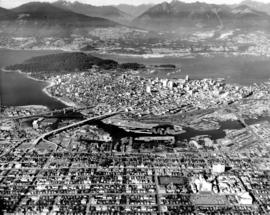
Aerial view of Pacific Terminal showing grain elevators and shipping containers in Vancouver Harbour
- AM1376-: 2015-025.1
- Item
- Jan. 23, 1976
109 results with digital objects Show results with digital objects
Aerial view of Pacific Terminal showing grain elevators and shipping containers in Vancouver Harbour
Aerial view of Pacific Terminal showing grain elevators and shipping containers in Vancouver Harbour
![[Aerial view of the University of British Columbia campus]](/uploads/r/null/3/b/3b26ad7abfb1609951345f3da59b98d3acb9e35f6e934378ca7fe7b7f51bc1d6/60118a86-5a6f-4ba9-b3b3-f32583aabd22-A23508_142.jpg)
[Aerial view of the University of British Columbia campus]
Part of Major Matthews collection
Oblique view. Photograph shows the University Endowment Lands.
Vancouver from the air looking north from over Little Mountain
Part of Major Matthews collection
Oblique view. Photograph shows Fairview, False Creek, R.C.A.F. Equipment Depot, Granville Island, Burrard Bridge, Granville (Street) Bridge, Downtown, West End, Stanley Park, Vancouver General Hospital, First Narrows and Burrard Inlet.
![[Aerial view looking north of the] Vancouver Wharves Ltd.](/uploads/r/null/a/3/a3e50a2d6a7688fca44a9f2fae2ec7ad724640047b3512a075ae83d4e5a3378e/ce172262-4f02-498d-ab6c-e23b06e50b09-A23502_142.jpg)
[Aerial view looking north of the] Vancouver Wharves Ltd.
Part of Major Matthews collection
Oblique view. Photograph shows P.G.E. yards, L & K Lumber, Norgate waterfront and West Vancouver.

Aerial photograph showing oblique view of Royal Columbian Hospital complex. Industrial development on the Fraser river visible in the background

Aerial photograph showing oblique view of Royal Columbian Hospital complex and surrounding neighborhood

Aerial photograph showing unidentified cannery in West Vancouver
![[Aerial photograph of downtown Nanaimo B.C.]](/uploads/r/null/9/b/9b5d6fcf945972bb10cacdedfe59a314267f99d1ef992e2e700a51cbe2bc7f80/6c0c2c60-d22a-48c1-b603-cdfa6801ce19-A38723_142.jpg)
[Aerial photograph of downtown Nanaimo B.C.]
Aerial view of shopping centre in downtown Nanaimo
![[Aerial photograph of downtown Nanaimo B.C.]](/uploads/r/null/6/5/65cde66194e385688e218734e0d220ed5ee7ad328ef1509e29b092e2bccd990c/9b09da99-a3e3-4278-bfef-a729495916b4-A38724_142.jpg)
[Aerial photograph of downtown Nanaimo B.C.]
Aerial view of ferry terminal, downtown Nanaimo

Lions Gate Hospital Area : North Vancouver Medical Centre Area
Areial photograph showing oblique view of Lions Gate Hospital

Aerial photograph of downtown Vancouver and Burrard Inlet waterfront
![[Aerial photograph of downtown Vancouver and Burrard Inlet waterfront]](/uploads/r/null/8/8/880f3eb359e4ba87a53dbb1528c9a52637f0890bd7fa1f026f2a2f8d55770b5f/07f1720e-3884-4019-874b-7ae1f538a5ea-A38733_142.jpg)
[Aerial photograph of downtown Vancouver and Burrard Inlet waterfront]
Aerial photograph looking west down Georgia Street, showing Lost Lagoon and Coal Harbour
![[Aerial photograph of north Burnaby near intersection of Lougheed and Sperling]](/uploads/r/null/f/6/f6d5ee2897afb7fca08a02c5516b73fa64f9dffc0b96e41335272f5049bff318/5e860ead-2105-466e-9535-74449508fa1c-A38734_142.jpg)
[Aerial photograph of north Burnaby near intersection of Lougheed and Sperling]
![[Aerial photograph of north Burnaby near intersection of Lougheed and Sperling]](/uploads/r/null/0/4/0402a7c6f7e8a28c8ca96ea5b930f8be591de0a42bfa4e4d588b57d8242e3df2/89b183bb-b4c9-4610-bd3d-233b78ca3218-A38735_142.jpg)
[Aerial photograph of north Burnaby near intersection of Lougheed and Sperling]
![[Aerial photograph of north Burnaby near intersection of Lougheed and Sperling]](/uploads/r/null/a/c/acb6598698ac88b27910cc65b590d05b02972403e78fecc5ae1a368cd0c4886b/32a0806e-9249-4407-8edf-f969bf2582fb-A38736_142.jpg)
[Aerial photograph of north Burnaby near intersection of Lougheed and Sperling]
![[Aerial view of Vancouver General Hospital complex]](/uploads/r/null/c/c/b/ccbd0b591ebec85e171caa06a1ebf508517f73a7f475af01cecc469616c2990c/c26a808e-5db5-4adb-a9e4-37fbf69526f0-CVA1399-623_142.jpg)
[Aerial view of Vancouver General Hospital complex]
Oblique view showing King Edward High School and False Creek
![[Aerial view of Vancouver General Hospital complex]](/uploads/r/null/0/b/0/0b051003f4129ccb3a10f83c721878865509cd6ebfc12da14ed1309cec7b5aa0/f30b5587-d175-4041-ad8c-5703a5db260b-CVA1399-624_142.jpg)
[Aerial view of Vancouver General Hospital complex]
Oblique view showing King Edward High School and False Creek
![[Job no. 794] : aerial photograph of Vancouver General Hospital complex and surrounding area](/uploads/r/null/a/7/a7db321ff6eeb9aabf663f37e723906fef772ef0c0d1372c083ffd18ff80a6bf/b3bf7b15-0b22-4c8b-84de-5cecf42d5a03-A38051_142.jpg)
[Job no. 794] : aerial photograph of Vancouver General Hospital complex and surrounding area
Photograph shows oblique view taken from south west
![[Job no. 794 : aerial photograph of Vancouver General Hospital Complex]](/uploads/r/null/c/3/c38902ff2c77f0c596178d5bad0a56cb37faccbe6cd068ca4801f44fb56c8925/cbc7c0a4-281a-4ba6-934c-7849a4d720c6-A38054_142.jpg)
[Job no. 794 : aerial photograph of Vancouver General Hospital Complex]
Photograph shows oblique view of V.G.H. and surrounding area taken from the west
![[Aerial view of] downtown bounded by Burrard Street, West Georgia Street, Granville Street and Sm...](/uploads/r/null/9/1/a/91aa0079c35a13cc3a22b0f7df0fb214970095aab0b5d871e09523e0499e3dac/42b18aee-e75f-4548-9e3a-bf196c0130ce-CVA145-17_142.jpg)
Part of City of Vancouver fonds
![[View looking northeast from north shore of False Creek over Smithe Street]](/uploads/r/null/8/f/6/8f6d7814ac04d1498743ba52bf07caf7e8dd2cf0290eb319665712b1edfdc180/c5c831e7-835b-48ff-8c87-5c157412dc0c-CVA145-2_142.jpg)
[View looking northeast from north shore of False Creek over Smithe Street]
Part of City of Vancouver fonds

Aerial view of P.N.E. grounds and surrounding area looking northeast

Aerial view of P.N.E. grounds and surrounding area looking northwest

Aerial view of P.N.E. grounds and surrounding area looking northeast

Aerial view of P.N.E. grounds and surrounding area looking northeast
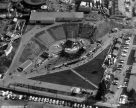
Aerial view of site of P.N.E. Festival of Logging


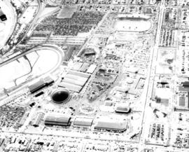
Aerial photograph of P.N.E. grounds, including Agrodome, Livestock building, Pacific Showmart

Aerial photograph of P.N.E. Playland

Aerial view of P.N.E. grounds looking northeast

Aerial view of P.N.E. grounds looking southeast

Aerial view of P.N.E. grounds and surrounding area looking northeast

Aerial view of P.N.E. grounds and surrounding area looking east
Aerial view of P.N.E. grounds looking east

Aerial view of P.N.E. grounds looking south

Aerial view of east half P.N.E. grounds looking south

Aerial view of P.N.E. grounds and surrounding area looking north

Aerial view of P.N.E. grounds looking northeast

Aerial view of P.N.E. grounds and surrounding area looking northeast

Aerial view of P.N.E. grounds and surrounding area looking east

Aerial view of P.N.E. grounds and surrounding area looking west

Aerial view of P.N.E. grounds looking east

Aerial view of P.N.E. grounds looking southeast

Aerial view of P.N.E. grounds and surrounding area looking east

Aerial view of P.N.E. grounds and surrounding area looking northeast

Aerial view of P.N.E. grounds and surrounding area looking east