- AM738-S1-F5-: 1980-253.66
- Item
- [ca. 1960]
Item includes census land delineation code for cities, municipalities and villages.
63 results with digital objects Show results with digital objects
Item includes census land delineation code for cities, municipalities and villages.
Item includes inset maps of Creston area and Rossland Trail area, as well as census land delineation code for cities, municipalities and villages
09-03 : Okanagan Similkameen and Kettle Valleys
Item includes inset map of the Okanagan Valley, as well as census land delineation code for cities, municipalities and villages
Item includes census land delineation code for cities, municipalities and villages.
Item includes inset map of Nanaimo area and greater Victoria, as well as census land delineation code for cities, municipalities and villages
09-06 : Kamloops-Lillooet Region
Item includes census land delineation code for cities, municipalities and villages.
09-07 : Central Mainland Coast
Item includes census land delineation code for cities, municipalities and villages.
Item includes census land delineation code for cities, municipalities and villages.
Item includes census land delineation code for cities, municipalities and villages.
Item includes inset of Dawson Creek area, as well as census land delineation code for cities, municipalities and villages.
1957 edition road map, Surrey municipality
Item is a road map of Surrey and includes inset maps of North Surrey, White Rock, fire areas and wards, as well as a street index.
Addenda to mercantile routing map, B.C. and Alberta
Beautiful Brentwood Park : brochure cover
Beautiful Brentwood Park Burnaby, B.C.
Item consists of a brochure for proposed subdivision bounded by Willingdon, Lougheed, Delta Avenue, and Parker Street.
British Columbia : population by census divisions
British Columbia : population by census subdivisions
Item shows 1951 census figures and 1956 for provincial census subdivisions.
British Columbia : principal water power resources and distribution facilities
Item shows hydro installations and power distribution systems, both developed and undeveloped.
British Columbia rural enumeration districts
File consists of maps showing 1951 and 1956 boundaries of census enumeration areas, including railways, roads and watercourses.

Bus routings in the downtown area
Part contains textual information about bus routes and services.
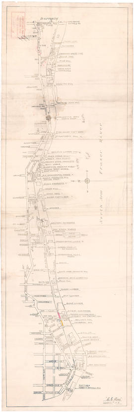
Businesses along the north shore of the North Arm of the Fraser River
Item is a map showing the locations and names of businesses located along the north shore of the North Arm of the Fraser River.
Ross, C.E.
City and District of North Vancouver
Item consists of a road map including railway lines, and urban and inter-urban bus routes.
City and District of North Vancouver
Item is a road map of North Vancouver used as a worksheet.
City of Chilliwack and surrounding area
Item shows main highways, roads, railways, power lines, dykes, and contours.

Item is a copy of a City of Vancouver Engineering Department map showing streets, railways, parks and golf courses. Indicates dedicated and undedicated streets open to traffic, streets open to restricted traffic only, and private roads.
Part is a map of the City of Vancouver showing block numbers, street car lines and numbers, fire halls, hospitals, electric and steam railways and bus routes. The map includes a 'dial', and associated street index used to find locations.
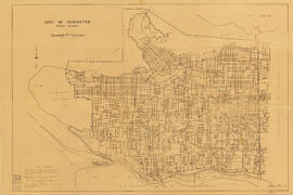
City of Vancouver British Columbia
Item is a map revised to include block numbers by census tracts, as well as geographic census area delineation codes.
City of Vancouver, British Columbia
Composite industrial map of metropolitan area : Lower Mainland, British Columbia
Item is a map showing railroads, main traffic arteries, new housing developments, lot numbers, municipal boundaries and industrial areas in Vancouver, West Vancouver, North Vancouver, Coquitlam, Delta, Richmond and Surrey. Industrial areas are categorised according to the following: existing heavy industry, potential heavy industry, existing light industry and potential light industry. The item also includes a breakdown of industrial areas by acreages.
Composite map of B.C. Electric downtown bus routes
Item is a map showing bus routes in downtown Vancouver on one side and textual information on bus routes on the other.

Composite map of B.C. Electric downtown bus routes
Part shows bus routes from Burrard Inlet in the north to False Creek in the south and from Main Street in the east to Thurlow in the west.

Part contains a street map of Vancouver showing streets, block numbers, bus routes, railway lines, boundaries, private roads and hospitals. The map includes a dial (a numbered circle, a paper indicator, a grid of block numbers and a street index used to find locations in Vancouver). A small inset shows the streets surrounding Queen Elizabeth Park, which are obscured on the main map where the indicator is attached.

Item is a street map of Vancouver showing block numbers, bus routes, railway lines, boundaries, private roads and hospitals in Vancouver. Map includes the printed portion of the dial (a numbered circle, a grid of block numbers and a street index used to find locations in Vancouver), but no indicator is attached. A small inset map shows the streets surrounding Queen Elizabeth Park.
Item is a map showing street car lines, bus lines, block numbers, railway lines, boundaries and hospitals in Vancouver. The map includes the printed portion of the dial (a numbered circle, a grid of block numbers and a street index used to find locations in Vancouver), but no indicator is attached.

Part contains a street map of Vancouver showing streets, block numbers, bus routes, railway lines, boundaries, private roads and hospitals. The map includes a dial (a numbered circle, a paper indicator, a grid of block numbers and a street index used to find locations in Vancouver). A small inset map shows the streets surrounding Queen Elizabeth Park, which are obscured on the main map where the indicator is attached.

Item is a map showing street car lines, bus lines, block numbers, railway lines, boundaries and hospitals in Vancouver. The map includes the printed portion of the dial (a numbered circle, a grid of block numbers and a street index used to find locations in Vancouver), but no indicator is attached.

Part consists of a street map of Vancouver showing block numbers, street car, bus, and railway lines, parks and hospitals. Map includes a dial (a numbered circle, a paper indicator, a grid of block numbers and a street index used to find locations).

Part contains a street map of Vancouver showing streets, block numbers, bus routes, railway lines, boundaries, private roads and hospitals. The map includes a dial (a numbered circle, a paper indicator, a grid of block numbers and a street index used to find locations in Vancouver). A small inset map shows the streets surrounding Queen Elizabeth Park, which are obscured on the main map where the indicator is attached.

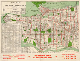
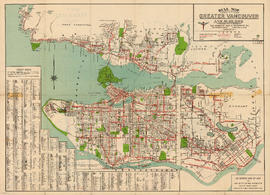
Dial map of Greater Vancouver and suburbs
Part contains a street map of Vancouver, West Vancouver, North Vancouver, and Burnaby showing railways, hospitals, parks and block numbers. The map includes the printed portion of the dial (a numbered circle, a grid of block numbers and a street index used to find locations), but no indicator is attached. Two small insets show the streets of Gleneagles in West Vancouver and Norgate Park in North Vancouver.

Dial map of Greater Vancouver and suburbs
Part contains a street map of Vancouver, West Vancouver, North Vancouver and Burnaby showing streets, block numbers, bus routes, railway lines, boundaries, private roads and hospitals. The map includes a dial (a numbered circle, a paper indicator, a grid of block numbers and a street index used to find locations).

Dial map of Greater Vancouver and suburbs
Part contains a street map of Vancouver, West Vancouver, North Vancouver, and Burnaby showing railways, hospitals, parks and block numbers. The map includes the printed portion of the dial (a numbered circle, a grid of block numbers and a street index used to find locations), but no indicator is attached. A small inset shows the streets of Gleneagles in West Vancouver.
Dial map of Greater Vancouver and suburbs
Part contains a street map of Vancouver, West Vancouver, North Vancouver and Burnaby showing streets, block numbers, bus routes, railway lines, boundaries, private roads and hospitals. The map includes the printed portion of the dial (a numbered circle, a grid of block numbers and a street index used to find locations), but no indicator is attached.

Dial map of Greater Vancouver and suburbs
Part contains a street map of Vancouver, Burnaby, New Westminster, West Vancouver, and North Vancouver showing railways, hospitals, parks and block numbers. The map includes two dials (numbered circles, paper indicators, a grid of block numbers and a street index used to find locations).