![Boundary [Road] and Hastings [Street traffic controller]](/uploads/r/null/3/6/c/36c134da01976a4cf68d2b48f3f5e52e4ddb4413077635146d11ce0b0be3d702/9dcd2a33-d4f4-43d6-95c7-795af1bcf4af-2019-103.0744_142.jpg)
Boundary [Road] and Hastings [Street traffic controller]
- COV-S505-1-: 2019-103.0744
- Item
- 1982
Part of City of Vancouver fonds
Boundary [Road] and Hastings [Street traffic controller]
Part of City of Vancouver fonds
![Boundary [Road] and Hastings [Street intersection, 4 of 4]](/uploads/r/null/5/0/2/50208124e2583c38e36f5e7d4f3f3b1c34757d9adf4da37f49c5951f79e78b92/452c3a64-3ed0-438d-aff8-c85f22109a0c-2019-103.0743_142.jpg)
Boundary [Road] and Hastings [Street intersection, 4 of 4]
Part of City of Vancouver fonds
![Boundary [Road] and Hastings [Street intersection, 3 of 4]](/uploads/r/null/e/b/7/eb73fcb4a69c9fd0df16c0472a7193c28811af6303f355b164cc419a3ebcea91/6c1547dc-100c-43c4-9b7b-a5f0fd9f0a1f-2019-103.0742_142.jpg)
Boundary [Road] and Hastings [Street intersection, 3 of 4]
Part of City of Vancouver fonds
![Boundary [Road] and Hastings [Street intersection, 2 of 4]](/uploads/r/null/1/3/7/1372fe5015e011e4c493845130b7a4d8bc11b5ea6cc4dce82dfd76f1e17a0063/e562b602-5f49-4f14-8df8-f4957407027f-2019-103.0741_142.jpg)
Boundary [Road] and Hastings [Street intersection, 2 of 4]
Part of City of Vancouver fonds
![Boundary [Road] and Hastings [Street intersection, 1 of 4]](/uploads/r/null/3/2/e/32e8022712055e15d6a884ce4d3b6bde8c183ce39eaa58dceed794b0c1823b7c/9ba96e1b-7a82-444d-83c1-1e0266075398-2019-103.0740_142.jpg)
Boundary [Road] and Hastings [Street intersection, 1 of 4]
Part of City of Vancouver fonds
![Boundary [Road] and 1st [Avenue traffic controller]](/uploads/r/null/c/d/e/cde43ca550dbf98e28432d50cba233198ea385d60b8b6e2f33081539d0c85382/fdb4b9cd-6f57-4f47-a2da-edfbe6dee61e-2019-103.0739_142.jpg)
Boundary [Road] and 1st [Avenue traffic controller]
Part of City of Vancouver fonds
![Boundary [Road] and 1st [Avenue intersection, 4 of 4]](/uploads/r/null/9/2/8/92860e1f6bca8c02e34cf69a5e6285926581ca681f19103891d5299f5a97d941/d697dc98-c7d1-44dc-bbec-832c4d835e5a-2019-103.0738_142.jpg)
Boundary [Road] and 1st [Avenue intersection, 4 of 4]
Part of City of Vancouver fonds
![Boundary [Road] and 1st [Avenue intersection, 3 of 4]](/uploads/r/null/0/e/b/0eb84d4df0834828fffd15aa8c90e29ae98e8d7040fc46a568105f72be5ef66c/02113de5-d2cd-4e28-bbe6-58c8689f1c03-2019-103.0737_142.jpg)
Boundary [Road] and 1st [Avenue intersection, 3 of 4]
Part of City of Vancouver fonds
![Boundary [Road] and 1st [Avenue intersection, 2 of 4]](/uploads/r/null/5/5/0/5501dd5bf9e63254ec85ca5fe31e7dcd6e8eef7ffedfbf4b241ae92633ab02e1/2e4b9431-8b6b-48f9-b55c-1dba477c3b81-2019-103.0736_142.jpg)
Boundary [Road] and 1st [Avenue intersection, 2 of 4]
Part of City of Vancouver fonds
![Boundary [Road] and 1st [Avenue intersection, 1 of 4]](/uploads/r/null/9/6/9/9695bcecd4922866e0d049bef69cec7da9d5a1e7f2c53aa08f694a933c84d0c0/1055bd04-2c1a-4115-a1d3-63ff237ee0bd-2019-103.0735_142.jpg)
Boundary [Road] and 1st [Avenue intersection, 1 of 4]
Part of City of Vancouver fonds
![Boundary [Road] and Lougheed [Highway traffic controller]](/uploads/r/null/c/2/5/c257bc2d90a574935880b968cf65718543e8e417527023a84b8faafc744998ca/e1e764a6-7822-42f6-a76e-e341ae5274ad-2019-103.0729_142.jpg)
Boundary [Road] and Lougheed [Highway traffic controller]
Part of City of Vancouver fonds
![Boundary [Road] and Lougheed [Highway intersection, 4 of 4]](/uploads/r/null/c/4/7/c473bfe8bfcb3d91b70b6e5f55f7c689561ee15f264269fe6ae08857d943361a/971a971f-7dcb-48d7-b294-4c3869ac6f7b-2019-103.0728_142.jpg)
Boundary [Road] and Lougheed [Highway intersection, 4 of 4]
Part of City of Vancouver fonds
![Boundary [Road] and Lougheed [Highway intersection, 3 of 4]](/uploads/r/null/f/e/a/fea66ce7f8ba4ceb872c3ac8aa0e193318323b37c5d5c5cfd2ce870221349295/cddb44ab-bdb5-427f-acfc-beed6766b14c-2019-103.0727_142.jpg)
Boundary [Road] and Lougheed [Highway intersection, 3 of 4]
Part of City of Vancouver fonds
![Boundary [Road] and Lougheed [Highway intersection, 2 of 4]](/uploads/r/null/7/c/6/7c66798238b311cb7b53060bbcc659a12be9bea585029ab352cc27df7c7477b3/246b25e9-695f-4b02-8e8f-553830210325-2019-103.0726_142.jpg)
Boundary [Road] and Lougheed [Highway intersection, 2 of 4]
Part of City of Vancouver fonds
![Boundary [Road] and Lougheed [Highway intersection, 1 of 4]](/uploads/r/null/5/2/e/52e18fe991968bc1dfcb36801aada715afbf37e38985d738e597d7124fe49ddf/5ad5714f-054c-4908-aa04-6c53775679b6-2019-103.0725_142.jpg)
Boundary [Road] and Lougheed [Highway intersection, 1 of 4]
Part of City of Vancouver fonds
![Boundary [Road] and Grandview [Highway traffic controller]](/uploads/r/null/1/e/9/1e9190e49ced6d16a147d6d10fb2a31463466cd09355c0a63dc8a67f5a7bbde9/4efd17d0-6828-4b07-8eb2-e6b3aa1352dd-2019-103.0724_142.jpg)
Boundary [Road] and Grandview [Highway traffic controller]
Part of City of Vancouver fonds
![Boundary [Road] and Grandview [Highway intersection, 4 of 4]](/uploads/r/null/8/d/9/8d98e9ba9e29cc975bc40edc8d93b002b7318474ed1724b441467364400b75c4/d9757116-da4c-4d79-809a-1ace76ed5df0-2019-103.0723_142.jpg)
Boundary [Road] and Grandview [Highway intersection, 4 of 4]
Part of City of Vancouver fonds
![Boundary [Road] and Grandview [Highway intersection, 3 of 4]](/uploads/r/null/9/8/8/988a1cd8c44a00df45c46267bcd28b8634c806ffcfe83929f11809b4e97cf9c0/993eed54-87f0-4d72-b7f5-5cc8b81dd598-2019-103.0722_142.jpg)
Boundary [Road] and Grandview [Highway intersection, 3 of 4]
Part of City of Vancouver fonds
![Boundary [Road] and Grandview [Highway intersection, 2 of 4]](/uploads/r/null/f/4/d/f4d5db90202b70d2c82b1fa18dffe58db3006c8a6dd9066283bae2fcbe5e486e/bcd557af-e000-48fd-8538-74159a983f92-2019-103.0721_142.jpg)
Boundary [Road] and Grandview [Highway intersection, 2 of 4]
Part of City of Vancouver fonds
![Boundary [Road] and Grandview [Highway intersection, 1 of 4]](/uploads/r/null/e/6/9/e69256cb356f6c4c26b74977d6af9544d409579d744b228bcf65f9952220281c/814b74d6-d6b8-435e-bbe9-2d1be85a9c3b-2019-103.0720_142.jpg)
Boundary [Road] and Grandview [Highway intersection, 1 of 4]
Part of City of Vancouver fonds
![Boundary [Road] and Canada Way [intersection, 4 of 4]](/uploads/r/null/b/c/4/bc43d54bed614afef2be4c9febd5f50b3ce16d5b229b53160db5e7887f126567/3fbfd6d3-6cbc-46b2-ab18-fc032a74bd8b-2019-103.0719_142.jpg)
Boundary [Road] and Canada Way [intersection, 4 of 4]
Part of City of Vancouver fonds
![Boundary [Road] and Canada Way [traffic controller]](/uploads/r/null/a/5/e/a5e0e26be1eaf3143be5851b227bd94a85877fd76c33c27b8137d4ad583c8a8b/c680cfc2-a620-4c50-ba85-cad52884a19f-2019-103.0718_142.jpg)
Boundary [Road] and Canada Way [traffic controller]
Part of City of Vancouver fonds
![Boundary [Road] and Canada Way [intersection, 3 of 4]](/uploads/r/null/3/a/4/3a441294f6cab41ff91a08e5801054950dbad3193c81c4c85c42e2daf9b16972/1979c5c9-fb11-4c4a-8232-0848632ddac5-2019-103.0717_142.jpg)
Boundary [Road] and Canada Way [intersection, 3 of 4]
Part of City of Vancouver fonds
![Boundary [Road] and Canada Way [intersection, 2 of 4]](/uploads/r/null/8/6/9/869760b38cac4f0279f5b6f2950539b0734ad08bf3b4a1c4581f3f3785be9ac2/d4b59d88-4f2f-451e-a320-0280a4b2ab9c-2019-103.0716_142.jpg)
Boundary [Road] and Canada Way [intersection, 2 of 4]
Part of City of Vancouver fonds
![Boundary [Road] and Canada Way [intersection, 1 of 4]](/uploads/r/null/7/6/7/7675e158669e68f36e99466e129db3b730001dd9ce153821f1981ee73233c0cb/4a1d7b7a-83d7-4658-ac97-3e9d7baad724-2019-103.0715_142.jpg)
Boundary [Road] and Canada Way [intersection, 1 of 4]
Part of City of Vancouver fonds
![Boundary [Road] and Kingsway [traffic controller]](/uploads/r/null/e/4/6/e46a398613dc48302bdb921895e388fa26f292213254889bef2226ebac2f77c0/9ca9180a-7397-4009-9fc0-fe4e589248a1-2019-103.0704_142.jpg)
Boundary [Road] and Kingsway [traffic controller]
Part of City of Vancouver fonds
![Boundary [Road] and Kingsway [intersection, 4 of 4]](/uploads/r/null/2/4/f/24f3720760cf801eb006ac76bb0cfc7d8fb04ea2f597a081f6be29051b5e369c/5d57d00c-dbbf-4553-8660-bdf6fc54a857-2019-103.0703_142.jpg)
Boundary [Road] and Kingsway [intersection, 4 of 4]
Part of City of Vancouver fonds
![Boundary [Road] and Kingsway [intersection, 3 of 4]](/uploads/r/null/9/1/3/9137f0ba2a952e0b69a29ed5de592fd78677b7f1bc98c013b37ba8594899de7a/386c0bc0-0496-41c3-9840-17f071993d40-2019-103.0702_142.jpg)
Boundary [Road] and Kingsway [intersection, 3 of 4]
Part of City of Vancouver fonds
![Boundary [Road] and Kingsway [intersection, 2 of 4]](/uploads/r/null/6/7/f/67ff18ce27673f4b7eb4c03c47d07d0f749636277aab9a6ea44a07a70fba6571/50d3cce2-aeb2-4e77-9236-573dbea8f887-2019-103.0701_142.jpg)
Boundary [Road] and Kingsway [intersection, 2 of 4]
Part of City of Vancouver fonds
![Boundary [Road] and Kingsway [intersection, 1 of 4]](/uploads/r/null/0/2/2/02262cc3e7b316bf51bd9656b28f9e089cfdc4b7a99473fd5c08d4c9302d127c/88cc4727-279d-456f-8e3c-7de3be1c913a-2019-103.0700_142.jpg)
Boundary [Road] and Kingsway [intersection, 1 of 4]
Part of City of Vancouver fonds
![Boundary [Road] and Marine Way [traffic controller]](/uploads/r/null/6/7/8/678879723b742f0884e0383ca3bd2b61bbde7dd840f91c21a1fe752942a9f928/1040b1a8-8d2d-4cd4-b3a2-d76f49af3135-2019-103.0699_142.jpg)
Boundary [Road] and Marine Way [traffic controller]
Part of City of Vancouver fonds
![Boundary [Road] and Marine Way [intersection, 4 of 4]](/uploads/r/null/4/8/e/48e1cf3b9fa9080ee49c00f4c5a5c2e1160a784a886fc0bc51be08d9c0bf4265/769ddfc1-cb8a-4fce-9535-857903f6e5c9-2019-103.0698_142.jpg)
Boundary [Road] and Marine Way [intersection, 4 of 4]
Part of City of Vancouver fonds
![Boundary [Road] and Marine Way [intersection, 3 of 4]](/uploads/r/null/1/4/5/145374f880f1305d6c90eeeb05789bcaca34b427ec36b3167ae09d1b41898e4c/897168b6-f26f-4fd0-9ff1-6eabfa2842ff-2019-103.0697_142.jpg)
Boundary [Road] and Marine Way [intersection, 3 of 4]
Part of City of Vancouver fonds
![Boundary [Road] and Marine Way [intersection, 2 of 4]](/uploads/r/null/c/6/2/c624f5c77f69993fe65c80bd7dc6875f05ba95b11f18c376c1c6cc2bd9c1103a/ef9d4ed8-4708-4c6c-b665-27475a82bdce-2019-103.0696_142.jpg)
Boundary [Road] and Marine Way [intersection, 2 of 4]
Part of City of Vancouver fonds
![Boundary [Road] and Marine Way [intersection, 1 of 4]](/uploads/r/null/0/4/3/0430bf34efbc5a34d0cba81f7dfe3507e63617a9168e105399ac93b3bdcd7530/3af2a02b-db88-44e5-aa32-2c10bf9484a8-2019-103.0695_142.jpg)
Boundary [Road] and Marine Way [intersection, 1 of 4]
Part of City of Vancouver fonds
![[Two coupled interurban cars] at station on the B.C.E.R. Central Park lines](/uploads/r/null/b/f/bff4fd779ef9b55e93eb606a6df2ec7db7dee7aaca7ef1db8c07cc0759a14b14/d5da973a-464d-4154-8fa6-0846c6e633aa-A02218_142.jpg)
[Two coupled interurban cars] at station on the B.C.E.R. Central Park lines

Central Mortgage and Housing, 1203 Royal Bank Bldg. : interior and exterior of new house, Burnaby

Central Mortgage and Housing, 1203 Royal Bank Bldg. : interior and exterior of new house, Burnaby

Central Mortgage and Housing, 1203 Royal Bank Bldg. : interior and exterior of new house, Burnaby

Central Mortgage and Housing, 1203 Royal Bank Bldg. : interior and exterior of new house, Burnaby
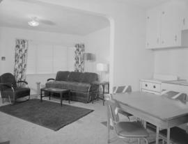
Central Mortgage and Housing, 1203 Royal Bank Bldg. : interior and exterior of new house, Burnaby

Simon Fraser University, Burnaby 2, B.C., Canada : aerial looking east
Item is a postcard showing an aerial view of Simon Fraser University. The back of the postcard includes personal correspondence addressed to Elizabeth Schuler.
![[Aerial view of Vancouver and Burnaby]](/uploads/r/null/f/b/fbdba44a19d2b4928094d872a6a16513550380c67160420213fe19581531e9c6/bb3aa326-0dd0-4dbe-879c-2a4a1527d49f-A66597_142.jpg)
[Aerial view of Vancouver and Burnaby]
Part of Major Matthews collection
Photograph shows Vancouver Technical School, Grandview Highway and Renfrew Playing Fields.
![[Aerial view of Burrard Inlet, Hastings-Sunrise, Burnaby and the District of North Vancouver]](/uploads/r/null/d/f/df7e11c97173ce0473c454f0a01569b641972f6efdc12bf192edbc42119542d6/6d72f89b-9b55-48c4-bef6-04eb2137f1d3-A66600_142.jpg)
[Aerial view of Burrard Inlet, Hastings-Sunrise, Burnaby and the District of North Vancouver]
Part of Major Matthews collection
Photograph shows Exhibition Park and P.N.E. Golf Course, Second Narrows Bridge, New Brighton Park, Callister Park, Burrard Inlet, Lynn Creek, Lynn Park, Seymour Creek, Vancouver Harbour Commissioners Railway, Inspected Shingles Ltd., Cascade Rock and Gravel Co. Ltd., Canadian Shingle Co. Ltd. (Capilano Timber Co. Ltd.), Alberta Pool Elevator, Columbia Grain Elevator Co. Ltd., Canadian Pacific Railway, Girls Industrial School and Old Peoples Home sites.

Madge Hogarth's investiture at Simon Fraser University
Part of Hamber family fonds

Norwegian Picnic, Central Park
Part of Major Matthews collection
Group portrait showing Consul Bjorke, Reverend Nantrup, Maitland, Degraves, Reverend Olsen and Mr. J.E. Johnston
![[Two storey home with car parked by garage]](/uploads/r/null/8/2/8/828d6edd52754940a09551f7c8be129f9e9b090b999574f3d2c77d5122989ff3/21af3d05-9057-47c0-ad3f-4a70a78d3211-CVA16-5_142.jpg)
[Two storey home with car parked by garage]
Item is a photograph showing the home of Burnaby Councillor Charles Rummel and family, then located at 1805 Inverness Street in Burnaby.

Group portrait showing a W.A.C.
![[St. Nicholas Parish Church]](/uploads/r/null/9/0/90336e9fa34f23a68dcebab56be65461664582663a067adc91311c029f4a5a5f/526fef8a-b9a8-45b6-895a-208dccb84b95-A09141_142.jpg)
Part of Major Matthews collection
Photograph shows Anglican church at corner of Triumph Street and Ingleton Street, Burnaby.

Dial map of Greater Vancouver and suburbs
Part contains a street map of Vancouver, Burnaby, New Westminster, West Vancouver and North Vancouver showing block numbers, street car, bus, and railway lines, parks and hospitals. Map includes two dials (a numbered circle, a paper indicator, a grid of block numbers and a street index used to find locations). A small inset map shows the Capitol Hill/Scenic Park area of Burnaby in greater detail.