Tidal current charts, Vancouver Harbour : inside front cover
Tidal current chart, Vancouver Harbour : two hours before maximum ebb at First Narrows
Tidal current chart, Vancouver Harbour : maximum ebb at First Narrows
Tidal current chart, Vancouver Harbour : one hour after maximum ebb at First Narrows
Tidal current chart, Vancouver Harbour : two hours after maximum ebb at First Narrows
Tidal current chart, Vancouver Harbour : maximum flood at First Narrows
Plan of the City of Vancouver
Point Grey, B.C. : district map
Burrard Inlet : Vancouver sheet : British Columbia
Lower Mainland provincial electoral districts
Map of downtown Vancouver
Wrigley's offical arrow city map : Greater Vancouver and New Westminster : map cover
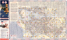
Price list of new subdivision : Hastings Townsite, close to city limits
Price list
Dial map of Greater Vancouver and suburbs
Map of Lulu Island and Sea Island ; Municipality of Delta ; Municipality of Surrey ; Municipality of Langley ; Map of Maillardville
Vancouver, B.C. city map : street index to Vancouver map, detail map of Downtown Vancouver, and tourist attractions
Visitors map of Vancouver
Insurance Plan of Port Coquitlam : sheet 3
B.C. Electric Rly. Co. Ltd. plan showing transit services in Vancouver city as at end of 1951
B.C. Electric Rly. Co. Ltd. plan showing transit services in Vancouver city as at end of 1951 : verso with annotations
Map of the municipalities of New Westminster, British Columbia
Map of Greater Vancouver
What the man who comes to Vancouver wants to know
City of Vancouver [park sites June/80]
City of Vancouver, British Columbia
Chinatown existing
Plan of re-subdivision of lots 3 to 14, subn [subdivision] 2 of bk [block] 3. D.L. 391 & 392
Vancouver, B.C. Plan showing location of water pipes, hydrants, etc. [Kitsilano]
Map of City of Vancouver, British Columbia
Map of City of Vancouver, British Columbia
Cheakamus power survey for City of Vancouver, 1930-1931 : general plan & profile : sheet no. 1 [Garibaldi Lake to Cheakamus Lake] to accompany report of E.A. Cleveland dated November 30th 1931
Cheakamus power survey for City of Vancouver, 1930-1931 : proposed storage reservoir at Daisy Lake : sheet no. 5 to accompany report of E.A. Cleveland dated November 30th 1931
Cheakamus power survey for City of Vancouver, 1930-1931 : plan showing proposed development near Mile 19 - P.G.E. Rly. : sheet no. 6 to accompany report of E.A. Cleveland dated November 30th 1931
Cheakamus power survey for City of Vancouver, 1930-1931 : plan showing proposed diversion works near Mile 19 - P.G.E. Rly., detail sheet : sheet no. 7 to accompany report of E.A. Cleveland dated November 30th 1931
Cheakamus power survey for City of Vancouver, 1930-1931 : topographical plan from Alpha Lake to Cheakamus River, above Mile 34, P.G.E. Rly. : sheet no. 8 to accompany report of E.A. Cleveland dated November 30th 1931
Map showing route Vancouver to Mission
Sheet 9 : Clark Drive to Slocan Street and Triumph Street to Charles Street
Sheet 11 : Carrall Street to Clark Drive and waterfront to Keefer Street
Sheet 15 : Oak Street to Main Street and False Creek to Sixteenth Avenue
Sheet 18 : Trutch Street to Maple Street and English Bay to Third Avenue
Sheet 14 : Ash Street to St. George Street and Marine Drive to Fraser River
Sheet 15 : Ash Street to St. George Street and Fifty-eighth Avenue to Marine Drive
Sheet 17 : Argyle Street to Vivian Street and Sixty-second Avenue to Kent Street
Sheet 21 : Burrard Street to False Creek and waterfront to Robson Street
Sheet E : University Endowment Lands to Wallace Street and Sixteenth Avenue to Twenty-seventh Avenue
Sheet K : Wallace Street to Trafalgar Street and Twenty-seventh Avenue to Thirty-eighth Avenue
Sheet Q : Churchill Street to Cambie Street and Thirty-eighth Street to Forty-ninth Avenue


![City of Vancouver [park sites June/80]](/uploads/r/null/9/4/9484add7c4684ea3838e4d00ee8add3ecf85d78d5aa8fe2780cae273e59556a5/bd2464d8-2aa9-4501-aba6-8b3f7d130a42-MAP1032_142.jpg)


![Plan of re-subdivision of lots 3 to 14, subn [subdivision] 2 of bk [block] 3. D.L. 391 & 392](/uploads/r/null/4/a/4a0ea6aa076433c7bcad0c847f7acb3bb1046f7abf2801c48b97d9ca58f49a73/9bd508e4-c85e-4090-b266-27571c5d4dbc-MAP754_142.jpg)
![Vancouver, B.C. Plan showing location of water pipes, hydrants, etc. [Kitsilano]](/uploads/r/null/0/e/0e33cc4d2f081f551fe6919d35ea37236a6e237a2f5927834d275556995fccfc/0f6ac1ff-8457-41f3-a386-26328c66a4b0-MAP72_142.jpg)


