Vancouver City : plan of Subdivision of lot 301, Group 1, New Westminster District
Vancouver and Northern Railway, 1908
Vancouver
Vancouver
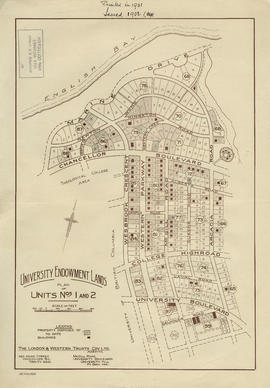
University Endowment Lands : plan of units nos. 1 and 2
University Endowment Lands : plan of units nos. 1 and 2
University Endowment Lands : plan of units no. 1 and 2
[Third section of] Shaughnessy Heights
Southerly portion. Vancouver Island
Sectional map [Kaslo Street to Yale Street to Cotton Drive to East 1st Avenue]
[Second section of] Shaughnessy Heights
Second section : Shaughnessy Heights
Powell Lake
Portions of New Westminster District and Vancouver Island
Port Moody, the western terminus of the Canadian Pacific Railway
Plan showing lands occupied in Stanley Park near Brockton Point, City of Vancouver, B.C.
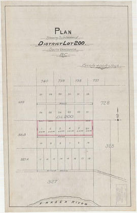
Plan shewing subdivision of District Lot 200. South Vancouver, B.C.
Plan of West Vancouver Municipality
Plan of townsite at Eburne
Plan of town of Lonsdale : situate [sic] on harbour opposite City of Vancouver
Plan of the townsite of North Vancouver
Plan of the town of Newcastle, English Bay
Plan of the municipality of South Vancouver
Plan of the City of Vancouver, British Columbia
Plan of the City of Vancouver, British Columbia
Plan of the City of Vancouver, B.C.
Plan of the City of Vancouver
Plan of subdivision of part of D.L. 526, New Westminster District, B.C., Kitsilano, City of Vancouver
Plan of subdivision of part of D.L. 526 : South Vancouver
Plan of sub-division of lot 2027, group 1, New Westminster District, B.C., to be sold by public auction at Vancouver, B.C.
Plan of subdivision of D in lot 183 and subdivision of J in lot 182, City of Vancouver
Plan of re-subdivision of lots 3 to 14, subn [subdivision] 2 of bk [block] 3. D.L. 391 & 392
Plan of provincial government property being a sub-division of a portion of expired timber lease situated in North Vancouver, New Westminster district, B.C., to be sold by public auction
Plan of provincial government property being a portion of townsite of Vancouver and sub-division of lot 540, group 1, New Westminster District, B.C., to be sold by public auction at Vancouver, B.C.
Plan of Provincial Government property being a portion of Townsite of Vancouver
Plan of Point Grey Municipality [ward boundaries]
Plan of part of sub-division of district lot 540, South Vancouver, provincial government property
Plan of part of subdivision of district lot 540. South Vancouver
Plan of part of D.L. 540
Plan of New Westminster City and suburban lots
Plan of Lot 6311, Vancouver, B.C. fronting on Kitsilano Indian Reserve No. 6
Plan of Greater Vancouver, British Columbia
Plan of government subdivision at Point Grey, B.C.


![[Vancouver, B.C. : district lots]](/uploads/r/null/4/a/4a5c15633319c3754d3aa0cc525470bfebcf5a98ad8caeedf44b777194f300bd/2f055d65-47f7-4679-bb91-66b8f1843d2f-MAP531_142.jpg)


![[Third section of] Shaughnessy Heights](/uploads/r/null/b/9/c/b9c97036cadac8b6ffc53f2380c1c158d767da3473d29ad1b04968cc742d132e/0301116d-9946-489d-a272-9d6453523103-MAP331_142.jpg)

![Sectional map [Kaslo Street to Yale Street to Cotton Drive to East 1st Avenue]](/uploads/r/null/5/b/5b3ce173622ff68f920706abdf2b71af76caf9469cb2cbd3346b37f55694015e/4e7b285b-63cb-45b1-8e0c-6002788dbae6-MAP427_142.jpg)
![[Second section of] Shaughnessy Heights](/uploads/r/null/9/4/d/94d42178bb60a8c60cdc002199430e863ae830696947ad73807b5fd11046c39a/72c651d3-6742-4c5c-a0bc-d83c3526a9ba-MAP330_142.jpg)


![Plan of town of Lonsdale : situate [sic] on harbour opposite City of Vancouver](/uploads/r/null/c/5/d/c5d4b56db1d7f9e1cf57dd5a974f6fcb23507e64543bad1bdd8f62139042389f/1cc57eaf-6c92-438e-a65d-335940738df7-MAP686_142.jpg)


![Plan of re-subdivision of lots 3 to 14, subn [subdivision] 2 of bk [block] 3. D.L. 391 & 392](/uploads/r/null/4/a/4a0ea6aa076433c7bcad0c847f7acb3bb1046f7abf2801c48b97d9ca58f49a73/9bd508e4-c85e-4090-b266-27571c5d4dbc-MAP754_142.jpg)


![Plan of Point Grey Municipality [ward boundaries]](/uploads/r/null/a/c/a/aca691b3d6e49d092070fc230a88f5ca7bd346fc8c5894892d7cdc5a79b535ee/9a14b192-1858-43aa-ab28-d0b03a2304eb-MAP360_142.jpg)


