
Redevelopment plan for Jericho Department of National Defence lands

Project 2, area "h" and part of "b" : condition of buildings

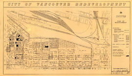
Redevelopment project no. 2 area a-6, including existing blocks 72, 73, 87, 88, D.L. 196 : site plan and general location of utilities plan no. 3

Project 2, area "h" and part of "b" : proposed property acquisitions project 2

Project 2, part of area "a" : existing utilities, water and sewer

Project 2, part of area "a" : existing utilities, gas, electricity and telephone

Project 2, part of area "a" : utility diversions and rearrangements

Project 2, part of area "a" : identification plan

Project 2 : generalized plan of redevelopment

Project 2, part of area "a" : condition of buildings

Project 2, part of area "a" : plan of redevelopment

Part of area "a" : plan of redevelopment, Strathcona

Project 2, part of area "a" : pavements, curbs and sidewalks

Project 2 : generalized plan of redevelopment

Project 2, part of area "a" : condition of buildings

Project 2, part of area "a" : existing utilities, water and sewer

Project 2, part of area "a" : existing gas, electricity and telephone

Project 2, area "h" and part of "b" : condition of buildings

Project 2, part of area "a" : pavements, curbs and sidewalks

Project 2, part of area "a" : plan of redevelopment

Project 2, area "h" and part of "b" : existing gas, electricity and telephone

Project 2, area "h" and part of "b" : pavements, curbs and sidewalks

Project 2, area "h" and part of "b" : existing utilities, water and sewer

Project 2, area "h" and part of "b" : plan of redevelopment

Project 2, part of area "a" : identification plan

The official street name map of the City of Vancouver

Project 2: identification plan

Project 2, part of area "a" : aerial photograph

Project 2, part of area "a" : aerial photograph

Project 2 : generalized plan of redevelopment
Project 2, area "h" and part of "b" : plan of redevelopment

Project 2, area a-2 : proposed property acquisitions project 2

Project 2, area a-2 : condition of buildings

Redevelopment Project No. 2 Plan No. 1
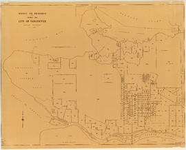
District lot boundaries within the City of Vancouver

City of Vancouver, British Columbia

Proposed zoning : comprehensive redevelopment areas

Key map showing proposed areas for partial and comprehensive redevelopment

Proposed industrial subdivision - Joyce and Vanness

City of Vancouver, British Columbia

Rezoning application map (Point Grey Road)
![Map showing City of Vancouver, British Columbia [index map]](/uploads/r/null/a/f/b/afbf0b3832ff37e3af2c10d63547517135bca50be83ddddfcd25914b3c7b8f1d/6903af1e-3c6e-4577-9c0a-0967550524a7-LEG1153_142.jpg)
Map showing City of Vancouver, British Columbia [index map]

Properties from Victoria Drive to Nanaimo Street and Burrard Inlet to Triumph Street

Plan to accompany report on proposed bridge at Marpole across North Arm of Fraser River
![Legend [for colour coding land use]](/uploads/r/null/3/1/2/3120f4f71566883ae774f5f08ae6795bc55fcd40d9f4bdd29f8f25dc782e0a9f/89bc7dbc-376d-43ba-bc88-a0fda629d99a-LEG1153_142.jpg)
Legend [for colour coding land use]

Vancouver British Columbia. Major street plan

Vancouver, British Columbia

Vancouver - the third largest city of the dominion, and Canada's chief Pacific port

Map of City of Vancouver, British Columbia

Plan of District Lot boundaries. City of Vancouver, B.C.