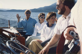
Group on boat cruise in the Burrard Inlet
- AM1576-S6-12-F60-: 2011-010.1406
- Item
- [1986]
361 results with digital objects Show results with digital objects
Group on boat cruise in the Burrard Inlet

Group on boat cruise with Lion's Gate Bridge in background


Item is a photograph showing Sharen Smith (left, seated) and two others, unidentified.

Randie Smith on boat cruise with Canada Place in background

Group on boat cruise in the Burrard Inlet
Item is a photograph showing Michael Francis (centre) and group on a boat cruise in the Burrard Inlet.


Group on boat cruise in the Burrard Inlet

Group on boat cruise in the Burrard Inlet
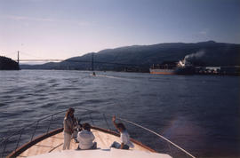
Group on boat cruise with Lion's Gate Bridge in background

View of Canada Place from boat cruise

Group seated at indoor table on boat cruise

Fishing boats in Burrard Inlet coming in with their catch
Part of Vancouver Express fonds
Item is a photograph of fishing boats in Burrard Inlet, West Vancouver Sentinel Hill in background.
![Second Narrows [on] harbour tour](/uploads/r/null/b/2/e/b2ea67536bdb443ce9ad21b9ce328068de0d7aa9252a7ea17ab7aeb9cec67c8f/78042a33-bebb-41f2-ac8e-edfa5de1b752-CVA289-266_142.jpg)
Second Narrows [on] harbour tour
Part of William Orson Banfield fonds

Part of William Orson Banfield fonds

Part of William Orson Banfield fonds

Part of William Orson Banfield fonds

Vancouver Harbour. British Columbia
Part of City of Vancouver Archives technical and cartographic drawing collection
Item is a map sheet containing three nautical charts. The main map shows English Bay and Burrard Inlet and the land bordering these bodies of water, including North and West Vancouver, Downtown Vancouver, the University Endowment Lands and Port Moody. Inset maps depict the north arm of Burrard Inlet and a chart showing Vancouver Island in relation to the B.C. coast and the state of Washington, U.S.A.
Airstrip at Brockton Point (day flyings)
Part of City of Vancouver fonds
Item is an architectural drawing which depicts the overall design of a proposed airstrip in Burrard Inlet at Brockton Point. The drawing also depicts the associated waterfront expressway feeding onto the Lions Gate Bridge and a 6-lane tunnel under the First Narrows.
Foundation of Canada Engineering Corporation

Part of City of Vancouver Archives technical and cartographic drawing collection
Item is an architectural drawing of a Second Narrows crossing, bridging Vancouver and North Vancouver. The drawing consists of an elevation of the bridge, as well as a plan of the bridge and the north and south approaches.
Tidal current charts : Vancouver Harbour, British Columbia
Part of City of Vancouver Archives technical and cartographic drawing collection
Item is a booklet containing twelve charts showing tidal currents in Vancouver Harbour at different points in the tidal cycle.
Vancouver Harbour : plan of south shore, Burrard Inlet between Heatley Ave. and Victoria Dr.
Part of City of Vancouver Archives technical and cartographic drawing collection
Item is a map which shows parcels of land along Burrard Inlet and district lots in downtown Vancouver. Piers, factories and mills along the waterfront are identified. Soundings are shown in feet.
National Harbours Board

Vancouver Harbour : Sheet 1 (First Narrows to Second Narrows)
Part of City of Vancouver Archives technical and cartographic drawing collection
Item is a nautical chart of Vancouver Harbour from First Narrows in the west to Second Narrows in the east, showing soundings in fathoms, tidal information, anchorages, beacons, and waterfront businesses. Street names are shown on land areas.

Vancouver Harbour : Sheet 2 (Point Grey to Second Narrows)
Part of City of Vancouver Archives technical and cartographic drawing collection
item is a nautical chart of Burrard Inlet and Vancouver Harbour from Point Grey in the west to Second Narrows in the east, showing soundings in fathoms, tidal information, anchorages, beacons, and waterfront businesses. Street names are shown on land areas. A Royal Canadian Air Force bombing range at Jericho Beach is identified as a danger area.

Vancouver Harbour : Sheet 3 (Second Narrows to Port Moody)
Part of City of Vancouver Archives technical and cartographic drawing collection
Item is a nautical chart of Vancouver Harbour from Second Narrows in the west to Port Moody in the east, showing soundings in fathoms, tidal information, anchorages, beacons, and waterfront businesses. Street names are shown on land areas.

Vancouver North. British Columbia
Part of City of Vancouver Archives technical and cartographic drawing collection
Item is a topographical map showing the eastern portion of Sechelt Peninsula, Keats Island, southern portion of Gambier Island, Bowen Island, West Vancouver, North Vancouver, and Vancouver. City streets and blocks are shown, as well as surveyed parcels of land. Map also shows depth contours in fathoms for Howe Sound and Burrard Inlet.

Part of Major Matthews collection
Item is a print of a map by Major James Skitt Matthews, City Archivist, showing villages, landmarks and rivers of Howe Sound and Burrard Inlet using their indigenous names. The map also shows elevations and wildlife populating the area. It was compiled between 1931 and 1937, with the assistance of August Jack Haatsalano (Khahtsahlano), whose attestation is included on the map. Notes on the map explain the map's nomenclature.
Matthews, James Skitt, Major

Indian villages and landmarks, Burrard Inlet and Howe Sound before the whitemans came
Part of Major Matthews collection
Item is a manuscript map showing the territory of the Squamish peoples using Squamish geographic names, as told to him by August Jack Khatsahlano.
Matthews, James Skitt, Major

Port of the City of Vancouver. Isometric view from the south-west
Part of City of Vancouver Archives technical and cartographic drawing collection
Item is a set of maps printed on one sheet. The main map shows an isometric view of the port of Vancouver from Stanley Park through the Second Narrows Bridge (including North Vancouver). The perspective point appears to be located above the Granviile Street and West Georgia Street intersection. Note that the isometric view of locations west of Granville Street is from the south-east, rather than the south-west, as indicated in the title.
The map depicts the port infrastructure, including piers, drydocks and companies located in the port.
The inset maps are a key plan showing the location of the port relative to the Lower Mainland as a whole, and a larger-scale map entitled "Plan of the Port of the City of Vancouver from Coal Harbour to Second Narrows". It contains more detail about the names of the various piers, drydocks and companies and shows the North Vancouver port facilities as well as south shore ones.

Part of Stuart Thomson fonds
Part of City of Vancouver Archives technical and cartographic drawing collection
Item is an architectural drawing depicting existing and proposed water mains crossing the First Narrows.The drawing includes a plan, sections and details, as well as a key plan of the site location.
Greater Vancouver Water District
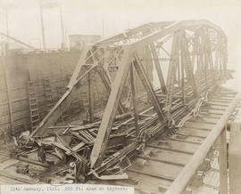
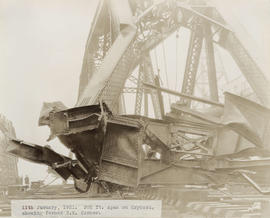
300 foot span on drydock : January 11, 1931
Item is a photograph related to the building of the Second Narrows Bridge.

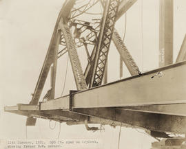
300 foot span on drydock, showing former north half of west side : January 11, 1931
Item is a photograph related to the building of the Second Narrows Bridge.
300 foot span on drydock, showing former north west corner : January 11, 1931
Item is a photograph related to the building of the Second Narrows Bridge.

300 foot span on drydock, showing former north east corner : January 11, 1931
Item is a photograph related to the building of the Second Narrows Bridge.
300 foot span on drydock, showing former south west corner : January 11, 1931
Item is a photograph related to the building of the Second Narrows Bridge.

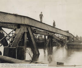
Detail of 300 foot span partly above water at Pacific Salvage Company's yard : January 7, 1931
Item is a photograph related to the building of the Second Narrows Bridge.
300 foot span partly above water at Pacific Salvage Company's yard : January 7, 1931
Item is a photograph related to the building of the Second Narrows Bridge.

Detail of 300 foot span partly above water at Pacific Salvage Company's yard : January 7, 1931
Item is a photograph related to the building of the Second Narrows Bridge.

18,000 ton floating drydock at Burrard Drydock Company yards : January 1931
Item is a photograph related to the building of the Second Narrows Bridge.

Detail of damage to bascule span by the hulk Pacific Gatherer : April 19, 1930
Item is a photograph related to the building of the Second Narrows Bridge.

Item is a photograph related to the building of the Second Narrows Bridge.
Image of missing 300 foot span : September 19, 1930
Item is a photograph related to the building of the Second Narrows Bridge.

Detail of damage done by the hulk Pacific Gatherer : April 19, 1930
Item is a photograph related to the building of the Second Narrows Bridge.

Hulk Pacific Gatherer drifting eastward at about 10:52 a.m. : September 13, 1930
Item is a photograph related to the building of the Second Narrows Bridge.

S.S. Losmar aground on south shore after colliding with 150 foot span : April 24, 1930
Item is a photograph related to the building of the Second Narrows Bridge.

View from above of damage to 150 foot span : April 24, 1930
Item is a photograph related to the building of the Second Narrows Bridge.