![Bayview [Elementary] School [at 2251 Collingwood Street]](/uploads/r/null/8/4/84146e68cd846eeeaae7e2bd5b42caedb758a2b24321969f1526b2cf31663f39/ec8a093d-2991-41d4-ae38-c216a26dc428-A58959_142.jpg)
Bayview [Elementary] School [at 2251 Collingwood Street]
- COV-S511---: CVA 780-179
- Item
- Dec. [19]78
Part of City of Vancouver fonds
Bayview [Elementary] School [at 2251 Collingwood Street]
Part of City of Vancouver fonds
![[Kitsilano] Ice Rink [at 2495 West 12th Avenue]](/uploads/r/null/e/b/eb721478621e4bda9a57c84a63bed97f2584c3d59a11c99b4a350144e51252bd/dc26c67f-7ca8-4fe5-807c-7e3c8c3c65dc-A58967_142.jpg)
[Kitsilano] Ice Rink [at 2495 West 12th Avenue]
Part of City of Vancouver fonds
Photograph also shows Connaught Park, the Greater Vancouver Regl, Sewage and Drainage and Water Distict (2294 West 10th Avenue), and apartment buildings 2285 West 10th Avenue (Patna Apartments) and 2586 Vine Street
![Simon Fraser [Elementary] School [at] 3185 Manitoba [Street]](/uploads/r/null/c/e/ceb7f0a743608fb0d43a03fedf7e0accac463f28944ff1fd2e6fb5ec70f58488/ec148232-5579-42c1-ac42-8a85607ed3de-A59091_142.jpg)
Simon Fraser [Elementary] School [at] 3185 Manitoba [Street]
Part of City of Vancouver fonds
![Shaughn[essy Elementary] School [at 4250 Marguerite Street]](/uploads/r/null/6/a/6af8bd8506d9332ec561ec9a2b132e98867e98b7d4c797370c6c707534cb8634/f3bdba72-facf-45ab-b3ab-e5a38a7d486e-A59154_142.jpg)
Shaughn[essy Elementary] School [at 4250 Marguerite Street]
Part of City of Vancouver fonds
![[The Vancouver] Chinese Public School [at] 499 E[ast] Pender [Street]](/uploads/r/null/9/a/9a4d898a4390e8a2cc895d51a65b2329c57ef923bce8139f2a23201e1392e2ce/dbe7f86b-7921-47b8-954b-5132f9ab67f3-A59159_142.jpg)
[The Vancouver] Chinese Public School [at] 499 E[ast] Pender [Street]
Part of City of Vancouver fonds

Sequoia sempervirens, Point Grey School
Part of City of Vancouver fonds
![Penticton [Street] and Broadway [intersection, 1 of 5]](/uploads/r/null/8/3/7/837e9102d30ac5961cb35e4422f69aa4f2db68d9391afd371d886ec33ca55131/a207c0a0-e6e7-48f0-a019-f542296a272c-2019-103.0822_142.jpg)
Penticton [Street] and Broadway [intersection, 1 of 5]
Part of City of Vancouver fonds
![[255 Dunlevy Avenue - Franciscan Sisters of the Atonement kindergarten]](/uploads/r/null/8/0/c/80c7f756ee8e0112f5e87a2034729f3e5999143d80daf61b1c8d9460e3511ea1/74da7436-833c-46cc-aa09-5119c36670e5-CVA1095-12444_142.jpg)
[255 Dunlevy Avenue - Franciscan Sisters of the Atonement kindergarten]
Part of City of Vancouver fonds
![[Sir William Dawson School, 2 of 20]](/uploads/r/null/5/7/0/570a8577312bcf3d5dee0cf747bc4ec6dad892bac92c0d3b59ee73f33e66359c/6cf6bb6e-2625-4385-906c-ace302c7e767-CVA1095-14400_142.jpg)
[Sir William Dawson School, 2 of 20]
Part of City of Vancouver fonds
![[Sir William Dawson School, 8 of 20]](/uploads/r/null/b/e/c/bec2592e6a4854f4e12f7618e97a381cca7733ab316e1a8eb69c35d26e1ede5f/dd6ac675-fa75-49f2-880f-fdd9de961732-CVA1095-14406_142.jpg)
[Sir William Dawson School, 8 of 20]
Part of City of Vancouver fonds
![[Sir William Dawson School, 9 of 20]](/uploads/r/null/8/3/1/831a3ab636dee5e1b181a6bf41ec66a646c2d8e1778bbfcedc3ba12baf606731/729a273c-2e7c-401f-a367-92d4838b8892-CVA1095-14407_142.jpg)
[Sir William Dawson School, 9 of 20]
Part of City of Vancouver fonds
![[Sir William Dawson School, 11 of 20]](/uploads/r/null/8/2/4/824e70a128ca4ad9fd26ed89193d16d6a2d4e2e234ab4d4f596b6944edc5b959/4921427d-bf19-4eac-acf6-c27e8d187bc6-CVA1095-14409_142.jpg)
[Sir William Dawson School, 11 of 20]
Part of City of Vancouver fonds
![[Sir William Dawson School, 15 of 20]](/uploads/r/null/0/5/3/053e56c487f873d155feb3e2135c00772ea6df96c0b22dcef775f6c9a6ec7c63/2d4d68e0-1553-4e57-8862-c47601976b1e-CVA1095-14413_142.jpg)
[Sir William Dawson School, 15 of 20]
Part of City of Vancouver fonds
![[Sir William Dawson School, 17 of 20]](/uploads/r/null/5/6/c/56c95ea0b607916d14ef9ece81c096204db6b757b7bf3867491ac38ecd161f86/15a94e16-95a3-4655-9e74-c764ffbfce40-CVA1095-14415_142.jpg)
[Sir William Dawson School, 17 of 20]
Part of City of Vancouver fonds
![[5350 East Boulevard - West Point Grey Secondary School, 1 of 2]](/uploads/r/null/0/5/c/05cfbef02ca60a6838f973c5a7a75c716afd9516bf497cf61d84f8f48effa058/3a2bbf4d-5cb4-47d9-9ce5-64929c622f4c-CVA1095-15269_142.jpg)
[5350 East Boulevard - West Point Grey Secondary School, 1 of 2]
Part of City of Vancouver fonds
![[499 East Pender Street - The Vancouver Chinese Public School, 1 of 3]](/uploads/r/null/3/2/5/32505cb465c7a69c744031d63c5a896e3ce34c052b29953bf573de48c84a9a30/5a5fec9c-9cf5-4660-bf28-096c72701824-CVA1095-15271_142.jpg)
[499 East Pender Street - The Vancouver Chinese Public School, 1 of 3]
Part of City of Vancouver fonds
![[499 East Pender Street - The Vancouver Chinese Public School, 2 of 3]](/uploads/r/null/4/3/7/437b976324dbfbc26eee13537888cd85f4f7065dd0c235cc1a324549c50c21ed/cf8de275-9412-408f-86e3-2750d70e7ec6-CVA1095-15272_142.jpg)
[499 East Pender Street - The Vancouver Chinese Public School, 2 of 3]
Part of City of Vancouver fonds
![[499 East Pender Street - The Vancouver Chinese Public School, 3 of 3]](/uploads/r/null/d/9/a/d9a53dc8a66539630d884812b0fea9615d8c7b1cce6610636c961f2d9a90509f/315e5242-c422-4a59-87f6-d50adcd69b75-CVA1095-15273_142.jpg)
[499 East Pender Street - The Vancouver Chinese Public School, 3 of 3]
Part of City of Vancouver fonds
![Strathcona/West End [School building]](/uploads/r/null/7/4/d/74d861fd4c0006e1fb37e0e374b1a8c7f061b28896159fee2e51ece03af8ba35/f668f430-40e1-42c3-8870-5675005dc86d-CVA1095-15388_142.jpg)
Strathcona/West End [School building]
Part of City of Vancouver fonds
![[Seymour School, 2 of 2]](/uploads/r/null/b/e/0/be086ae60f896cfe7f60261966b07eac427d9826b73423ade573576f1297b676/d962f47d-c16e-468e-939c-673a38308008-CVA1095-15395_142.jpg)
Part of City of Vancouver fonds
![[500 East Pender Street - Lord Strathcona Elementary School, 4 of 4]](/uploads/r/null/2/a/b/2ab3126b54a1ea56aa9f0791aaaa25f95d407bc55707af05c620e69021b912b1/9f759a6e-f5b1-4dcd-9abf-9cf3b6c93685-CVA1095-13787_142.jpg)
[500 East Pender Street - Lord Strathcona Elementary School, 4 of 4]
Part of City of Vancouver fonds
Photograph depicts entrance to the school off of Keefer Street.
![[1130 Keefer Street - Seymour Elementary School]](/uploads/r/null/e/5/c/e5cb222fac5a8adb22519a7296449b4dc4aaf4a4de1b7784a0b69d247c325048/5e79dd71-0158-44e3-9eac-820c430676df-CVA1095-13254_142.jpg)
[1130 Keefer Street - Seymour Elementary School]
Part of City of Vancouver fonds
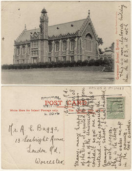
This postcard includes personal correspondence. Sent to Mr. A. E. Baggs of Worcester, England.
![Queen Elizabeth's [School] Sports Day 1958 & 1959](/uploads/r/null/4/1/418549/2bc4b4ca-1ddb-4490-a358-45b83809f2c6-V00234_142.jpg)
Queen Elizabeth's [School] Sports Day 1958 & 1959
Part of Vancouver School Board fonds
Item is a moving image/film documenting school children and teacher involved in various sporting events.
![[School buidling]](/uploads/r/null/4/1/d/41d180811de4ef150e9fc20cbf7713ab4a27b51a03f02ed12164b22e4ad4b47f/8bca8e93-bc97-42e0-a7ad-fa3bccedcee8-CVA1095-08699_142.jpg)
Part of City of Vancouver fonds
![Bayview School [group photograph]](/uploads/r/null/5/7/571b8afe7da55c7f099d52696be6bfb868e54ff58d193d8a0719fb50a21716f6/0ad008aa-ed5b-4423-8ab9-90abc2d35481-A59802_142.jpg)
Bayview School [group photograph]
Douglas Osborne Sudbury is identified by circle on print.
![Bayview School [group photograph]](/uploads/r/null/b/9/b93ccc48c18d2949827ffb5c018527c33d15fc46a5fff67a4e5ced3f3930f1d8/1f53fe4a-2757-40ef-8e19-ab86702400d3-A59803_142.jpg)
Bayview School [group photograph]
Douglas Osborne Sudbury is identified by circle on print.
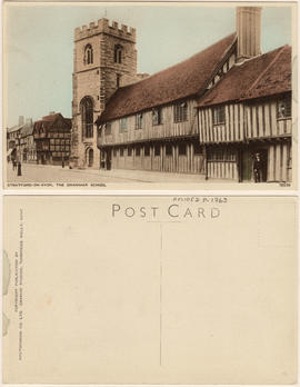
Stratford-on-Avon, The Grammar School

Open Air School at East 20th and Clark Drive with children on school grounds

First graduating class of the Vancouver School of Decorative and Applied Art
Photograph shows the following individuals, from left to right, seated: Marjorie Lynne, Lilias Farley, Bea Lennie, Margaret Williams, And Frances Gatewood; standing: Yit Conho, Fred Amess, Charles Scott, Phyl Kirkpatrick, Vera Weaterbie, and an unidentifi
![City of Vancouver [park sites June/80]](/uploads/r/null/9/4/9484add7c4684ea3838e4d00ee8add3ecf85d78d5aa8fe2780cae273e59556a5/bd2464d8-2aa9-4501-aba6-8b3f7d130a42-MAP1032_142.jpg)
City of Vancouver [park sites June/80]
Part of City of Vancouver Archives technical and cartographic drawing collection
Map is a City Engineering Department base map of Vancouver, with parks hand-coloured in green. Shows city blocks and Canadian Pacific, Canadian National and Great Northern Railway lines. Golf courses, hospitals, schools, theatres and other structures are identified. "Metric Vancouver" and "Guide Map 15" appear in the bottom right corner of the map.

City of Vancouver, British Columbia
Part of City of Vancouver Archives technical and cartographic drawing collection
Item is the eastern half of a map showing city blocks, transportation infrastructure, recreational facilities, hospitals, schools, theatres and other structures are identified. MAP 1036b is the western half of this map.
Vancouver (B.C.). Engineering Services

Sheet 9 : Clark Drive to Slocan Street and Triumph Street to Charles Street
Part of City of Vancouver Archives technical and cartographic drawing collection
Item is a section showing the area from Clark Drive to Slocan Street and Triumph Street to Charles Street. Includes streets and roads, blocks, lots, legal descriptions, railways, parks, schools and drill hall. The Town of Hastings is indicated on the map.
Vancouver (B.C.). Office of the City Engineer

Sheet 11 : Carrall Street to Clark Drive and waterfront to Keefer Street
Part of City of Vancouver Archives technical and cartographic drawing collection
Item is a section showing the area from Carrall Street to Clark Drive and waterfront to Keefer Street. Includes streets and roads, blocks, lots, legal descriptions, railways, parks, schools, freight sheds, warehouses, piers and businesses along the waterfront.
Vancouver (B.C.). Office of the City Engineer

Sheet 15 : Oak Street to Main Street and False Creek to Sixteenth Avenue
Part of City of Vancouver Archives technical and cartographic drawing collection
Item is a section showing Oak Street to Main Street and False Creek to Sixteenth Avenue. Includes streets and roads, blocks, lots, legal descriptions, railways, schools, monastery, Vancouver General Hospital and City Hall.
Vancouver (B.C.). Office of the City Engineer

Sheet 21 : Burrard Street to False Creek and waterfront to Robson Street
Part of City of Vancouver Archives technical and cartographic drawing collection
Item is a section showing Burrard Street to False Creek and waterfront to Robson Street. Includes streets and roads; blocks, lots and legal descriptions; the locations of hotels, court house, businesses, parks, and schools; crown leases; C.P.R. land and the company's Piers B and C, yards, sheds and depot; the B.C. Electric Railway Carrall Street Yard; and the Union Steamship Company.
Vancouver (B.C.). Office of the City Engineer

Sheet E : University Endowment Lands to Wallace Street and Sixteenth Avenue to Twenty-seventh Avenue
Part of City of Vancouver Archives technical and cartographic drawing collection
Item is a section showing the area from Wallace Street to Trafalgar Street and Sixteenth Avenue to Twenty-seventh Avenue. Includes streets, roads, blocks, lots, legal descriptions, parks and schools.
Vancouver (B.C.). Office of the City Engineer

Sheet K : Wallace Street to Trafalgar Street and Twenty-seventh Avenue to Thirty-eighth Avenue
Part of City of Vancouver Archives technical and cartographic drawing collection
Item is a section showing the area from Wallace Street to Trafalgar Street and Twenty-seventh Avenue to Thirty-eighth Avenue. Includes streets, roads and sewers; blocks, lots and legal descriptions; and parks and schools.
Vancouver (B.C.). Office of the City Engineer

Sheet Q : Churchill Street to Cambie Street and Thirty-eighth Street to Forty-ninth Avenue
Part of City of Vancouver Archives technical and cartographic drawing collection
Item is a section showing the area from Churchill Street to Cambie Street and Thirty-eighth Street to Forty-ninth Avenue. Includes streets and roads; blocks, lots and legal descriptions; and schools and golf courses.
Vancouver (B.C.). Office of the City Engineer

Sheet 6 : Craddock Street to Boundary Road and Twenty-ninth Avenue to Fortieth Avenue
Part of City of Vancouver Archives technical and cartographic drawing collection
Item is a section showing the area from Craddock Street to Boundary Road and Twenty-ninth Avenue to Fortieth Avenue. Includes streets, roads, blocks, lots, legal descriptions, parks. railway lines and schools.
Vancouver (B.C.). Office of the City Engineer

Sheet 16 : Maple Street to Oak Street and False Creek to Sixteenth Avenue
Part of City of Vancouver Archives technical and cartographic drawing collection
Item is a sectional map of the "Old City" of Vancouver showing Maple Street to Oak Street and False Creek to Sixteenth Avenue. Includes streets and roads, blocks, lots, legal descriptions, railways, schools and parks. Indicates crown land leased to the C.P.R. and other bodies.
Vancouver (B.C.). Office of the City Engineer

Sheet 7 : Clark Drive to Slocan Street and Seventh Avenue to Eighteenth Avenue
Part of City of Vancouver Archives technical and cartographic drawing collection
Item is a section showing the area from Clark Drive to Slocan Street and Seventh Avenue to Eighteenth Avenue. Includes streets and roads, blocks, lots, legal descriptions, railways, parks and schools. Some annotations have been made in green ink.
Vancouver (B.C.). Office of the City Engineer

Sheet S.V. 14 : Duchess Street to Boundary Road and Twenty-ninth Avenue to Fortieth Avenue
Part of City of Vancouver Archives technical and cartographic drawing collection
Item is a section showing the area from Duchess Street to Boundary Road and Twenty-ninth Avenue to Fortieth Avenue. Includes streets, roads, blocks, lots, legal descriptions, parks, schools and B.C. Electric Railway lines. Annotations in pencil.
Vancouver (B.C.). Office of the City Engineer

Sheet 13 : Ontario Street to Clark Drive and First Avenue to Sixteenth Avenue
Part of City of Vancouver Archives technical and cartographic drawing collection
Item is a section showing the area from Ontario Street to Clark Drive and First Avenue to Sixteenth Avenue. Includes streets, roads, blocks, lots, legal descriptions, railways, parks and schools. Includes B.C. Electric Railway car barns. Annotations in pencil.
Vancouver (B.C.). Office of the City Engineer

Sheet 15 : Oak Street to Main Street and False Creek to Sixteenth Avenue
Part of City of Vancouver Archives technical and cartographic drawing collection
Item is a section showing Oak Street to Main Street and False Creek to Sixteenth Avenue. Includes streets and roads, blocks, lots, legal descriptions, railways, schools, monastery, Vancouver General Hospital and City Hall. Indicates crown land leased to the C.P.R.
Vancouver (B.C.). Office of the City Engineer

Sheet 17 : Trutch Street to Maple Street and Fourth Avenue to Sixteenth Avenue
Part of City of Vancouver Archives technical and cartographic drawing collection
Item is a section showing Trutch Street to Maple Street and Fourth Avenue to Sixteenth Avenue. Includes streets, roads, blocks, lots, legal descriptions, parks and schools. Annotations in pencil.

Sheet 23 : Stanley Park to Granville Street and Robson Street to False Creek
Part of City of Vancouver Archives technical and cartographic drawing collection
Item is a section showing the area from Stanley Park to Granville Street and Robson Street to False Creek. Includes streets, roads and railways; blocks, lots and legal descriptions; as well as parks, schools, hospitals and churches. Shows the Burrard Bridge and C.P.R. property. Annotations in ink and pencil.
Vancouver (B.C.). Office of the City Engineer

Sheet C : University Endowment Lands to Discovery Street and Fourth Avenue to Sixteenth Avenue
Part of City of Vancouver Archives technical and cartographic drawing collection
Item is a section showing the area from the University Endowment Lands to Discovery Street and Fourth Avenue to Sixteenth Avenue. Includes streets and roads; blocks, lots and legal descriptions; and parks and schools. Annotations in ink.
Vancouver (B.C.). Office of the City Engineer

Sheet D : Discovery Street to Trutch Street and Fourth Avenue to Sixteenth Avenue
Part of City of Vancouver Archives technical and cartographic drawing collection
Item is a section showing the area from Discovery Street to Trutch Street and Fourth Avenue to Sixteenth Avenue. Includes streets and roads; blocks, lots and legal descriptions; and parks and schools.
Vancouver (B.C.). Office of the City Engineer

Sheet G : Trafalgar Street to Granville Street and Sixteenth Avenue to Nanton Avenue
Part of City of Vancouver Archives technical and cartographic drawing collection
Item is a section showing the area from Trafalgar Street to Granville Street and Sixteenth Avenue to Nanton Avenue. Includes streets and roads; blocks, lots and legal descriptions; and parks, schools, railway lines and golf courses.
Vancouver (B.C.). Office of the City Engineer