![[Northwest facing cityscape view of the West End]](/uploads/r/null/8/1/8144b464121d2d606915a295fe4bfea95b903893f4ac909e59d22d27b3a6c7db/c58f4286-e96d-4189-ad75-9885f1b17ff7-A59249_142.jpg)
[Northwest facing cityscape view of the West End]
- COV-S511---: CVA 780-384
- Item
- 1966
Part of City of Vancouver fonds
Photograph also shows buildings in the West End, English Bay, Stanley Park, Coal Harbour, Burrard Inlet, and the North Shore
[Northwest facing cityscape view of the West End]
Part of City of Vancouver fonds
Photograph also shows buildings in the West End, English Bay, Stanley Park, Coal Harbour, Burrard Inlet, and the North Shore
![[Coal Harbour?]](/uploads/r/null/d/b/db2de6c93437b31527635deddfa2d1b0228f1dfd0d78c0bf6d754fd685fc663b/dccf9129-e23d-46e6-8e3f-0adde1d833b8-A16628_142.jpg)
Part of City of Vancouver fonds
Photograph shows marsh and water with gazebo in background.
![[Coal Harbour?]](/uploads/r/null/1/0/10b1e3b62444e17b20e5c87b9cb37773568bcad1eb9f6ef2efd8c228b7f06408/5aa04f62-7a7b-4a73-a8bf-7920b9573446-A16631_142.jpg)
Part of City of Vancouver fonds
Photograph shows marsh, water and bridge.
Part of City of Vancouver fonds
Item is a documentary film documenting the transportation and population issues that impact access to downtown Vancouver. Film contains scenes of driving on the Granville Street Bridge, people attending a show, on a beach and walking around city streets at both daytime and evening.

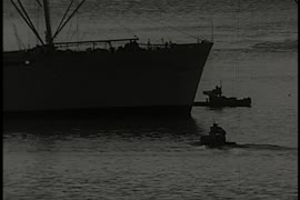
Visit of H.M.S Durbain, Despatch, and H.M.C.S Vancouver
Part of Stuart Thomson fonds
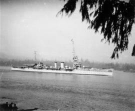
Ship - possibly H.M.S. Despatch
Part of Stuart Thomson fonds

Granville, B.C. 1885 - C.P.R. plan
![Harbour panorama [with] war canoe](/uploads/r/null/1/3/5/13571c1c3dc1e530a1e923e7264be75706d8af95af9a588dcf00ff1206d334c5/cd1f3b56-7afa-4c5c-ac2a-92ed07ed331a-2011-010_142.jpg)
Harbour panorama [with] war canoe

'Greenhill Park' ship explosion in Vancouver Harbour
![Twilight anchorage [ship in harbour]](/uploads/r/null/4/9/2/4923632d88dba51cffecddb31cbfd4980f43232a820db1e148f7cd30c20a8970/510e5af0-3f17-4494-8174-f501decfbc32-CVA293-104_142.jpg)
Twilight anchorage [ship in harbour]
![Outward bound [Ferncliff leaving the harbour]](/uploads/r/null/9/4/1/941ada3c187bf82c8b708a7f34b8b35801419807e0815d2ad523a12b9e6570be/b8290159-6586-40fc-a089-d7bdd4808d85-CVA293-128_142.jpg)
Outward bound [Ferncliff leaving the harbour]
![No wheat [view from Kitsilano Beach of freighter anchored in the harbour]](/uploads/r/null/a/f/7/af7f69cd835c3dcc952e2f300902fff6acddff87492c075566311f576b51c92b/8c5a57f2-5cdd-45ed-afd7-78b655941080-CVA293-135_142.jpg)
No wheat [view from Kitsilano Beach of freighter anchored in the harbour]
![No wheat [view from Kitsilano Beach of freighter anchored in the harbour]](/uploads/r/null/2/3/6/23667b976ce7a35f7a67eb8c0fbe7bf5f94840e88af4840d63ba4336aedc66f9/40c88020-4643-490e-afbc-b432b9612f3b-CVA293-135_142.jpg)
No wheat [view from Kitsilano Beach of freighter anchored in the harbour]

British Columbia - Vancouver skyline
Item is photograph showing downtown Vancouver looking north west towards Stanley Park and Coal Harbour.

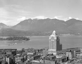
British Columbia - Vancouver skyline : view from north side of Westcoast bldg
Item is photograph showing view of Coal Harbour, Stanley Park, and Burrard Inlet from Westcoast Energy building.

British Columbia - Vancouver skyline : Westcoast building and scenery from inside
Item is photograph showing downtown Vancouver looking north west towards Stanley Park and Coal Harbour

British Columbia - Vancouver skyline : Westcoast bldg. and scenery from inside
Item is photograph showing Coal Harbour and Stanley Park.

British Columbia - Vancouver skyline : Westcoast bldg. and scenery from inside
Item is photograph showing Coal Harbour and downtown Vancouver.

British Columbia - Vancouver skyline : Westcoast bldg. and scenery from inside
Item is photograph showing Coal Harbour, Stanley Park, and Burrard Inlet.

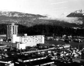
Item is photograph showing an aerial view downtown Vancouver looking northwest towards Coal Harbour and Stanley Park.
Item is photograph showing an aerial view downtown Vancouver looking northwest towards Coal Harbour and Stanley Park.
![[Coal Harbour and downtown Vancouver]](/uploads/r/null/9/6/963211ebd8afe965840840d585cec1a2b8ebc9fa5ccad89c0d8ff6fa5b09b325/aae76ee7-a000-4d73-be7e-1831535a08b6-CVA1435-630_142.jpg)
[Coal Harbour and downtown Vancouver]
Item is photograph showing Coal Harbour and downtown Vancouver, taken from the Stanley Park causeway.
![[Coal Harbour and downtown Vancouver]](/uploads/r/null/9/2/924cd84f7afa829f5183160b8a807996bf9c4e5c5aa58f8a386bfce3eb7e665a/d60e2151-8687-4709-b421-fc93e2bcfce5-CVA1435-632_142.jpg)
[Coal Harbour and downtown Vancouver]
Item is photograph showing Coal Harbour and downtown Vancouver, taken from the Stanley Park causeway.

British Columbia - Vancouver skyline
Item is photograph showing downtown Vancouver looking north west towards Coal Harbour and Stanley Park.
British Columbia - Vancouver skyline
Item is photograph showing downtown Vancouver looking north west towards Coal Harbour and Stanley Park.
British Columbia - Vancouver skyline
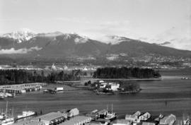
Item is aerial photograph showing Stanley Park and Coal Harbour.

British Columbia - Vancouver skyline
Item is photograph showing Coal Harbour and Burrard Inlet
British Columbia - Vancouver skyline : new office bldg. Vancouver
Item is photograph showing Coal Harbour and Stanley Park.

British Columbia - Vancouver skyline
Item is photograph showing an aerial view of Burrard Inlet showing the southern shoreline and parts of Stanley Park.

British Columbia - Vancouver skyline
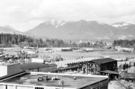
Item is aerial photograph showing Coal Harbour from the south shore.

British Columbia - Vancouver skyline
Item is aerial photograph showing Coal Harbour from the south shore.

Vancouver from top of old Hotel Vancouver
Photograph shows a view looking northeast

Prince Rupert buildings and harbour

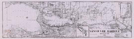
Vancouver Harbour : Sheet 3 (Second Narrows to Port Moody)
Part of City of Vancouver Archives technical and cartographic drawing collection
Item is a nautical chart of Vancouver Harbour from Second Narrows in the west to Port Moody in the east, showing soundings in fathoms, tidal information, anchorages, beacons, and waterfront businesses. Street names are shown on land areas.

Part of Hubert William Lovell fonds
Photograph was taken in the summer.

Eagle Harbour, old logging buildings
Part of Hubert William Lovell fonds
Photograph was taken in the summer.
![[View of] Deep Cove](/uploads/r/null/1/a/1a18c33f69dd89ad4f2e79c0137c837c16e817069547777a7c1f9daf2542a46f/4fe48ffe-0985-498a-acd7-92c6d74245b0-A03406_142.jpg)
![[View of] Victoria harbour](/uploads/r/null/2/e/2e8a0985a175dda5a26fef759d34134718505995fe8437669cf13a56c6b48c14/4e29bce9-209b-4aa9-b1f8-297e9d626dec-A07060_142.jpg)
![[Views of boats in] Deep Cove [harbour]](/uploads/r/null/b/9/b9f273fdf8c32c5165d86836e5ca1d3f2c41548f1aec61f7261df0be041d12a8/6a46c1b6-9ded-4685-a959-ced739e246f2-A03405_142.jpg)
[Views of boats in] Deep Cove [harbour]
Photograph shows the Immigration Building, the Marine Building and Deadman's Island

Lipsett boats - "Harris No.3", "Hollyburn"

The New Parliament Buildings, Victoria
Part of William Orson Banfield fonds
Harbour and bridge from Capitol Hill
Vancouver Harbour, British Columbia, 1964
Part of City of Vancouver Archives technical and cartographic drawing collection
Item is a nautical chart showing English Bay and Burrard Inlet with soundings in feet, anchorages, locations of submarine cables, and ferry lines. Land features include city blocks and district lot numbers. Includes inset maps of the North Arm of Burrard Inlet and Vancouver Island.

First Narrows, Burrard Inlet, B.C. showing Parthia and Burnaby shoals
Part of City of Vancouver Archives technical and cartographic drawing collection
Item is a map showing shorelines, estuaries of adjacent creeks, mud flats, tide levels and soundings in feet. Map notes velocity of current at First Narrows.
New Westminster (B.C.). Department of Public Works
![[Dredging] drill](/uploads/r/null/8/b/8bb6d6caa508ebafbe54a8a3d3a65f79ffaadd1478574fd193f15aa473444465/64564f45-3036-423d-a547-db9887092a15-A31773_142.jpg)
Part of Major Matthews collection

East half Granville Island before filling
Part of Major Matthews collection
Photograph shows harbour, log boom and wharves.
![Filling of government dock at Victoria, B.C. [Victoria outer dock]](/uploads/r/null/a/4/a407ab35e25717806ed19dee13e037e030e5e4a94cee438b0b27b6b923de43ce/82cdb86b-0638-46f6-8815-f9a538f91041-A31776_142.jpg)
Filling of government dock at Victoria, B.C. [Victoria outer dock]
Part of Major Matthews collection

R.M.S. "Empress of Russia" in Vancouver Harbour
Part of John William Freeston fonds
Panoramic view showing Burrard Inlet, the Immigration Building, C.P.R. Pier A, C.P.R. Pier D, Pier B-C construction site and Deadmans Island, Coal Harbour, Brockton Point and the Lions in the background