North from Mount Seymour

Point Atkinson

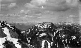
Ridge between Lions

The Lions

West Fork, Lynn Creek
![[Dredging] drill](/uploads/r/null/8/b/8bb6d6caa508ebafbe54a8a3d3a65f79ffaadd1478574fd193f15aa473444465/64564f45-3036-423d-a547-db9887092a15-A31773_142.jpg)
[Dredging] drill
![[Pacific Construction] Ltd. shipyards, Coquitlam, B.C.](/uploads/r/null/e/2/e23c736e1add9ecf575d4b4c856156f914e1a1ccb7dc0c473a2dbb49b052d724/b4e15b64-ad12-48eb-83dc-8e26c2a37059-A31754_142.jpg)
[Pacific Construction] Ltd. shipyards, Coquitlam, B.C.
![[Pacific Construction] Ltd. shipyards, Coquitlam, B.C.](/uploads/r/null/2/f/2f12cf893944fcd669af3702c34875c1cd8a3ca43308e89d5ccc416c2b7683d2/54751da9-1710-4a94-a0ed-82996493bb1f-A31756_142.jpg)
[Pacific Construction] Ltd. shipyards, Coquitlam, B.C.

Clearing rock slide at Hell's Gate, Fraser River

Clearing rock slide at Hell's Gate, Fraser River

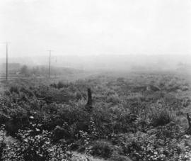
East half Granville Island before filling
![Filling of government dock at Victoria, B.C. [Victoria outer dock]](/uploads/r/null/a/4/a407ab35e25717806ed19dee13e037e030e5e4a94cee438b0b27b6b923de43ce/82cdb86b-0638-46f6-8815-f9a538f91041-A31776_142.jpg)
Filling of government dock at Victoria, B.C. [Victoria outer dock]
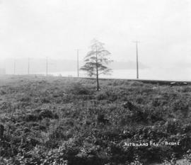
Kitsilano fill - before
Kitsilano fill - before

Scotch marine boilers of dredge no. 1
![[Brockton Point] Lighthouse [and fog bell]](/uploads/r/null/1/3/13bbda14088a610f04fe4e504d23f72dd0b7e608b7f6c59e4fc5eefe7cc19168/8ce5f79d-35ac-4dd6-beb0-663f859be809-A21485_142.jpg)
[Brockton Point] Lighthouse [and fog bell]
![[Henry Avison and his son Henry Stanley Avison outside the Park] Ranger's cottage [at Stanley Park]](/uploads/r/null/3/0/309ed9e1f2ff70a5560f8ff6bbe3bd2074825893e8728044ef0071249df328cd/d7887518-3d2a-4f87-ac02-64d08369a745-A21483_142.jpg)
[Henry Avison and his son Henry Stanley Avison outside the Park] Ranger's cottage [at Stanley Park]
![[Woman in a horse carriage] in the big tree [at Stanley Park]](/uploads/r/null/1/5/15a8b1239bee0b2cfc97459c6489bb992ca3d5e88cc36ec77840314d6678cd50/736227c6-3dec-4c33-b752-8a4b4e52deea-A21489_142.jpg)
[Woman in a horse carriage] in the big tree [at Stanley Park]
![English Bay [and Beach Avenue West of Chilco Street looking east]](/uploads/r/null/a/6/a650088a54f89d4b94ae91cf56f265f9e25cd551117b1d16abbda2a00e254ed2/56d725bf-28ed-4afd-b59a-fe35fcc32663-A21494_142.jpg)
English Bay [and Beach Avenue West of Chilco Street looking east]
![Reflections in the resevoir [at Stanley Park]](/uploads/r/null/f/1/f1fa87ee07aca1fb09a0c8142f43db4210cb375b90e4d939c4528b2c6b6db27d/9073dc75-38cc-43a5-a3c0-b467c33b8b83-A21488_142.jpg)
Reflections in the resevoir [at Stanley Park]
![View from Prospect Point [looking across First Narrows to Capilano Creek and showing Indian houses]](/uploads/r/null/6/a/6aeed0c0bf4e1cb93b608f4613ec247d86e62c48ecc1315bd7ff773519caa139/aef023c0-20f6-4fcd-ba68-2b9e396f783d-A21487_142.jpg)
View from Prospect Point [looking across First Narrows to Capilano Creek and showing Indian houses]
![[An Eveready Prestone Antifreeze billboard on the Continental Hotel at 1390 Granville Street]](/uploads/r/null/f/4/f477127c87e61a6b3b6f459554ce3a018519f680f0b9c5491ad2e1892c3d651f/603de7b5-dd86-47f4-bbdc-c9095c449c97-A20301_142.jpg)
[An Eveready Prestone Antifreeze billboard on the Continental Hotel at 1390 Granville Street]
![[Kingsway at Boundary Road]](/uploads/r/null/0/9/092e433ed069d0ecb5f976ae7ab9930590d2abef0adbcf8e8ae2041c60e2f24b/4ef6a8b6-f153-4441-910f-bc7c3b47eb88-A20219_142.jpg)
[Kingsway at Boundary Road]
![[Looking north from the Granville Bridge towards Pacific Street]](/uploads/r/null/d/8/d8a2276c82f8f9368cf73a0591eaa0b48835b40b1c02e7b301f049642521deb4/ffa103e3-cd8e-40d5-9c14-2523548d7855-A20298_142.jpg)
[Looking north from the Granville Bridge towards Pacific Street]
![[View looking south from the middle of the Burrard Bridge]](/uploads/r/null/e/8/e87dc75f507bb7bf9c24693e74689e14ee69490b2aa7e63bfb4c0e3fb25bcf3a/482d03d0-14e1-47ce-9d2b-6f7c0aae3308-A20290_142.jpg)
[View looking south from the middle of the Burrard Bridge]
![Broadway and Arbutus [Street] northeast city](/uploads/r/null/5/5/555750b588503a3322ebf29c1e45da7a1aedbd6e38a7c4b9013e674c6803ab7b/46fd7cf5-0743-4c2c-ad40-aafc16a81898-A20281_142.jpg)
Broadway and Arbutus [Street] northeast city
![Cambie [Street] and 2nd [Avenue] facing southwest](/uploads/r/null/5/a/5a86d00b9eb08dc97ecb318f2b9841db4b24e7cef92c93151f7ed8885b9c372a/6dbcd7b9-9280-424c-9f0c-cb581d9f4892-A20279_142.jpg)
Cambie [Street] and 2nd [Avenue] facing southwest
![Cambie [Street] and Broadway southwest](/uploads/r/null/0/7/078129b297c03cdee3f6799dc751d2be848b7146f12ad2d9e2c72700d08d109f/b81cc9ad-a8d9-43d7-8526-a1f15deb9eed-A20277_142.jpg)
Cambie [Street] and Broadway southwest
![Cambie [Street] between 8th [Avenue] and [Broadway]](/uploads/r/null/0/5/057ae381e5da57356f6e85d6a9f4d6d87fe79fe2d3a9305f5ef0538ae94d26df/2de278b1-bff3-4e09-9cbd-38d068d4db6c-A20276_142.jpg)
Cambie [Street] between 8th [Avenue] and [Broadway]
![Cornwall [Avenue] and Walnut [Street]](/uploads/r/null/1/2/12061a5e69986914a6c75fe76edaaa3b2d189e5e002e10fe897246884b3a196a/08e141a2-892a-462b-8234-18d903319936-A20286_142.jpg)
Cornwall [Avenue] and Walnut [Street]
![Granville [Street] and 8th [Avenue] northeast](/uploads/r/null/9/3/93c35e9c7dc441a0f3031655685a3ccfe76cbf390212fe65258af5af97aaffb7/3339122d-eb80-45ba-80b4-d76258862c28-A20269_142.jpg)
Granville [Street] and 8th [Avenue] northeast
![Granville [Street] and Cordova [Street] facing north](/uploads/r/null/7/1/711b67ed06dbe9ceed459c8fb0b5f576e26890e0f4b9a7bdb03a3bfbf987f906/e4eb0071-b3f8-4fdb-b046-94c057926585-A20241_142.jpg)
Granville [Street] and Cordova [Street] facing north
![Granville [Street] and Cordova [Street] south](/uploads/r/null/5/6/56cabb7517e584897084abcf3b5f0c12ca583773968a10d34f89985d1fe736bd/81624e69-0986-4d8c-9be0-714e78830045-A20240_142.jpg)
Granville [Street] and Cordova [Street] south
![Granville [Street] and Marine Drive southwest city](/uploads/r/null/3/b/3bc9390dada095d5d010393e87135ac4a082c191786bfd9e0d7be4d5e42e39b2/d7179077-357d-4d8b-a8b6-9539f8f50ddf-A20275_142.jpg)
Granville [Street] and Marine Drive southwest city
![Granville [Street] and Pacific [Street] southwest city](/uploads/r/null/2/2/22a6de536b7ec18dd9c47c4dfafd46c8c550be86d6ec795333ef81ed08c8b950/6775be53-eb53-4358-8cab-50505b2daea2-A20253_142.jpg)
Granville [Street] and Pacific [Street] southwest city
![Hastings [Street] and Vernon [Drive] southwest city](/uploads/r/null/0/5/05f80f72919a5cc3e37a41d188903588515ffbabe8c2c926c86281380376a6a6/fd806909-3311-48a5-bcd4-285d3615fc05-A20247_142.jpg)
Hastings [Street] and Vernon [Drive] southwest city

Kingsway and Broadway northeast
![Kingsway and Edmonds [Street on] north side city incoming](/uploads/r/null/b/a/ba05eda748307a0827332472c9e29aefd0c0dcb584ad376dbb0cf23bf857d13f/55eb2571-bf7e-4654-9630-fe4ce969b767-A20214_142.jpg)
Kingsway and Edmonds [Street on] north side city incoming
![Kingsway and Gilley [Avenue on] south side city outgoing](/uploads/r/null/1/6/16e55cf4106ddd65d99af715a0b8d81aa0419d5ebb0aedb31cc851c3fe99e5ae/a588197a-2628-46dc-8412-a31280de51ea-A20215_142.jpg)
Kingsway and Gilley [Avenue on] south side city outgoing
![Kingsway and McHardy [Street] north side city](/uploads/r/null/5/7/575bc61666b678f68cead301aa7ad7851f1abc5a0af25b1a68f566142c0af830/02dc9827-a60b-40ee-a417-9fa47da2947d-A20223_142.jpg)
Kingsway and McHardy [Street] north side city
![Kingsway and Moss [Street] north side city incoming](/uploads/r/null/f/2/f201ec05bf4c22fb97b352ee4aab23526ad54e074096c6f40c62ca9fd335f993/77a1850c-35d0-43d6-917f-03551b29d42f-A20227_142.jpg)
Kingsway and Moss [Street] north side city incoming
![Main [Street] and 5th [Avenue] southeast lit [billboards]](/uploads/r/null/9/2/92137ae56e6c972513a0fa7e745f96f14fbbdf873815db9bfea2d1617b2e226a/6f6127d3-cdf1-4466-98cb-fcb03c213d36-A20235_142.jpg)
Main [Street] and 5th [Avenue] southeast lit [billboards]
![Main [Street] and 7th [Avenue] northwest city](/uploads/r/null/4/a/4a305692bfd29dc4d8a7e500a6df135345bac2aeed8c063fb5bd8573ed15a848/750520de-f6ec-42fb-9993-b4251907d831-A20234_142.jpg)
Main [Street] and 7th [Avenue] northwest city
![Main Street between 4th [Avenue] southeast](/uploads/r/null/5/a/5adc6442c3515669d0fdcc552010fee67975c26a44d4a0088efefb914155c876/f8b46c84-1f2d-431c-ac17-66c66e8f243e-A20236_142.jpg)
Main Street between 4th [Avenue] southeast
![Main Street between 4th Avenue and 5th [Avenue] city](/uploads/r/null/4/4/445a23f4b03e999264be6a0b0fea77c5315c9aa646352e8dc0166174b7f4a13c/a997c042-3a0c-45d7-ab86-d4f3402fd4f1-A20237_142.jpg)
Main Street between 4th Avenue and 5th [Avenue] city
![Pacific Highway 1/2 mile east of Port Man Road [on] south side outgoing](/uploads/r/null/c/c/cc0f27c11e681d69fabaf913213a731ca3e82c18a992ecd78fa5177d8a1444dc/ab8fa803-170e-4eff-b798-dc43dbc4d86b-A20208_142.jpg)
Pacific Highway 1/2 mile east of Port Man Road [on] south side outgoing
![Pacific Highway 1/4 mile east [of] Port Mann Road south side incoming](/uploads/r/null/5/f/5fb1ed3749253c0735d7dd7b762833f8c95b1c95ab682c00bc0bd8ddb1046be9/916b884d-3179-4e97-afb6-21dd752ae588-A20211_142.jpg)
Pacific Highway 1/4 mile east [of] Port Mann Road south side incoming
![Pacific Highway 100 feet from customs [on] south side [of] highway incoming](/uploads/r/null/a/f/af88bd268467cecf5481dcfad3022a009fb6db54d9397bb13afa112719ecf0d6/add49f39-7ef3-43d1-9fac-39c9c6df7102-A20194_142.jpg)
Pacific Highway 100 feet from customs [on] south side [of] highway incoming

Roof of Ball Park
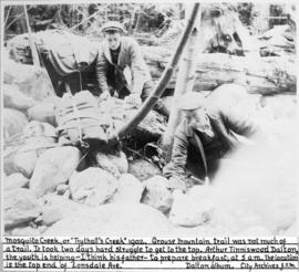
[Arthur Tinniswood Dalton and a man, probably his father, at Mosquito Creek or "Trythall's Creek" on their way up Grouse Mt.]