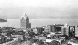
View from Roof Garden, Hotel Vancouver, Vancouver, B.C.
- AM54-S4-: Van Sc P8
- Item
- 1930
Part of Major Matthews collection
Photograph shows a view looking north including the Marine Building
View from Roof Garden, Hotel Vancouver, Vancouver, B.C.
Part of Major Matthews collection
Photograph shows a view looking north including the Marine Building
![[Looking northeast from Georgia Street from the Hotel Vancouver]](/uploads/r/null/6/3/63e4cb0982036a6ffb3d269b9757505dd2fd130896c126d0290164c76587e71d/72199e95-347b-404a-98c9-a6727a7f6ccd-A43257_142.jpg)
[Looking northeast from Georgia Street from the Hotel Vancouver]
Part of Major Matthews collection
Photograph shows the east side of the 600 Block Granville Street including the Hudson Bay Company store and the New York Block
![[Looking north from Georgia Street from the Hotel Vancouver]](/uploads/r/null/9/7/97e0cda9e3e6069a38aab5983c020f2d954c7c8d3df3707c37d19bfaefc1ed85/3f1b120e-1142-4754-96b3-399a240e2ec0-A43256_142.jpg)
[Looking north from Georgia Street from the Hotel Vancouver]
Part of Major Matthews collection
Photograph shows the 600 Block between Howe Street and Granville Street including part of the C.P.R. Park, the Van Horne Building and the Bank of Montreal
![[Looking northwest from Georgia Street from the roof of the Hotel Vancouver]](/uploads/r/null/3/e/3e78aa7a1d4d4210fdc17d391ece8c1437fc6e68115de6b0aa6c30506f2a7d4e/fd620b58-87ca-473a-a4c8-17218eb63664-A43255_142.jpg)
[Looking northwest from Georgia Street from the roof of the Hotel Vancouver]
Part of Major Matthews collection
Photograph shows the west side of the 600 Block of Howe Street including Manor House and Brockton Point in the background
![[View of the east side of the 600 Block Granville Street from the Hotel Vancouver]](/uploads/r/null/4/4/4425fb6fbb80b3749d053a61cd527c8178e50eaf7d19c06fe5a29423a3c99305/2fb46c95-d5cb-4300-9fe9-8e29cae87b74-A25789_142.jpg)
[View of the east side of the 600 Block Granville Street from the Hotel Vancouver]
Part of Major Matthews collection
Photograph shows the Hudson Bay Company store, the New York Block and the roof and spire of the Homer Street Methodist Church
![[Looking north from Georgia Street from the Hotel Vancouver]](/uploads/r/null/e/d/ed4c233f2e1cd9eee56c7b04ac27b10decea1348908ebee9b4f38674e25aa5d9/ae2582ab-d8dc-477a-9e94-63eab8f9d55e-A25788_142.jpg)
[Looking north from Georgia Street from the Hotel Vancouver]
Part of Major Matthews collection
Photograph shows the 600 Block between Howe Street and Granville Street including The Van Horne Building and the Bank of Montreal
Part of Major Matthews collection
Photograph shows the west side of the 600 Block of Howe Street including Manor House
![[Looking west along Georgia Street at Howe Street from the roof of the second Hotel Vancouver]](/uploads/r/null/e/a/eaf470ff6789cc2b12ce452e09b469421aa6854a8793f4caef7b539b19c66e58/dc88c4dd-55eb-431c-9db6-31525dadd68c-A25786_142.jpg)
[Looking west along Georgia Street at Howe Street from the roof of the second Hotel Vancouver]
Part of Major Matthews collection
Photograph shows Walker and Robinson Nursery and Christ Church Cathedral

Part of Major Matthews collection
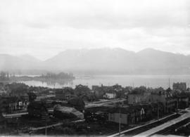
Oblique view looking north across the north arm of the Fraser River towards Marpole

Part of Major Matthews collection
Oblique view showing sawmills on the north arm of the Fraser River
![[Aerial view looking east towards the Second Narrows (Iron Workers Memorial) Bridge]](/uploads/r/null/a/3/a30e769b11d82234857ac24837baf510f2440359b92782f8e65bf107d5c50ffe/d0897c6d-49e8-4e61-b76c-6f04433a9e5b-A43252_142.jpg)
[Aerial view looking east towards the Second Narrows (Iron Workers Memorial) Bridge]
Part of Major Matthews collection
Oblique view showing the cantilever open
![Vancouver B.C. [from the air looking east from West End]](/uploads/r/null/a/3/a39a59fafd2c470a05e0b8ecba90843c0dcefd64faa8cd1695e25e8515c52ad7/4a63a71b-9508-45ea-b75a-27924fe36db8-A42964_142.jpg)
Vancouver B.C. [from the air looking east from West End]
Part of Major Matthews collection
Photograph shows buildings and houses along West Georgia Street and Pender Street.
![[Aerial view looking west over Point Grey]](/uploads/r/null/d/a/da370c91b8519769814da89cd1136fcd3872aa71fca7a7f1b176e6534e9caaef/a1ff0d0e-189b-42d3-9ad4-090a410a7ea2-A43251_142.jpg)
[Aerial view looking west over Point Grey]
Part of Major Matthews collection
Oblique view showing the Jericho Beach Golf Course and the R.C.A.F. aerodrome
![[Aerial view looking north over Downtown]](/uploads/r/null/4/b/4b54e616319b32d55e40e5c7404b5eccbd9b053f144a101245a1e709d1cfd4d2/1752a263-31cd-4155-880a-ead0fa54c115-A43250_142.jpg)
[Aerial view looking north over Downtown]
Part of Major Matthews collection
Oblique view showing part of the West End, the north end of the Granville Street and C.P.R. Kitsilano Trestle bridges, log booms, industries and the waterfront of False Creek and the C.P.R. docks and Burrard Inlet in the background
![[Aerial view looking east over Point Grey]](/uploads/r/null/6/e/6e6142341e688a43c05c88b90455b7a0b9857daa4b8b976c384474e010017e9b/d7b03617-741e-42e1-a20f-006407c2e6be-A43249_142.jpg)
[Aerial view looking east over Point Grey]
Part of Major Matthews collection
Oblique view
![[Aerial view looking east over Stanley Park, Coal Harbour and Burrard Inlet]](/uploads/r/null/d/0/d02fee694c486ac2accdeefb505d0dae5fcb42789ef16de49322d845e3c04b44/be8c34ce-7c09-4c0e-a395-f083c9134080-A43248_142.jpg)
[Aerial view looking east over Stanley Park, Coal Harbour and Burrard Inlet]
Part of Major Matthews collection
Oblique view
![[Aerial view looking north from False Creek]](/uploads/r/null/0/8/081746026b1559c2ace13027d77c668cba79e15800d0ca6ca466b205529e45b3/ce072490-3b01-4b65-8d61-bfaa102cca83-A43247_142.jpg)
[Aerial view looking north from False Creek]
Part of Major Matthews collection
Oblique view showing the West End and Downtown in the background
![[Looking southeast from Howe Street and Georgia Street]](/uploads/r/null/0/c/0cb9fbc2150f8c35cd20de9832c7e7964c2b83fb40b486054a61b5fba9b21762/95390cd4-399c-4126-b9d4-a24eecbd92ef-A43243_142.jpg)
[Looking southeast from Howe Street and Georgia Street]
Part of Major Matthews collection
View showing the second Hotel Vancouver
![[Looking east over Downtown from Howe Street near Georgia Street]](/uploads/r/null/e/b/ebfee7dd847b465697661512b7582f34aaa5fad21442ed77a5a7376f71aa834f/5109815e-0f76-40ee-b700-cbdff767f842-A43242_142.jpg)
[Looking east over Downtown from Howe Street near Georgia Street]
Part of Major Matthews collection
Panoramic view showing the Sun Tower, and the spire of Holy Rosary Cathedral
![Vancouver, B.C. [looking northeast over Downtown]](/uploads/r/null/e/0/e0b931b4691323339f6996f55fd7e1553581e50084154d17e8eecd20c1fd30cd/2492a23f-28cc-40ea-9f73-9366eb5c2b08-A43241_142.jpg)
Vancouver, B.C. [looking northeast over Downtown]
Part of Major Matthews collection
Panoramic view over Downtown showing the Rogers Building, the turret of the Bank of Montreal, the Post Office clock tower, the North Vancouver Ferry and Burnaby Mountain in the background
![[Looking north on Howe Street from Dunsmuir Street towards North Vancouver]](/uploads/r/null/d/0/d0b6611f857cee211c55fa3eef752b25fa67c29908d0a87c081d71b426926df8/04a53bfe-4591-488b-994e-204c81af7bcf-A43240_142.jpg)
[Looking north on Howe Street from Dunsmuir Street towards North Vancouver]
Part of Major Matthews collection
Panoramic view showing the Marine Building under construction and part of Piers A and B-C
![[Looking west from Downtown towards Deadman's Island and Stanley Park]](/uploads/r/null/2/c/2c705d0c121092f7e858257951ed62b6071985eaee35f9ab57a8a90282d8db52/6107a312-5bf8-440c-8e34-989aad82c345-A43239_142.jpg)
[Looking west from Downtown towards Deadman's Island and Stanley Park]
Part of Major Matthews collection
Panoramic view showing the Immigration Building

Part of Major Matthews collection
Photograph shows a northern view from Pender Street at Homer Street including Hastings Sawmill in the background
![[Northern view of Westminster Avenue (Main Street) from 7th Avenue]](/uploads/r/null/e/e/eedf5dc6b5cf6caafadff512ec18cf952b58c3fe76cbe821bad2890dd36af4ad/ead53220-dc8f-4f5e-9654-b6cea29e57c4-A43237_142.jpg)
[Northern view of Westminster Avenue (Main Street) from 7th Avenue]
Part of Major Matthews collection
Photograph shows the Westminster Avenue Trestle Bridge and False Creek in the background
![[Aerial view of the piers on the waterfront of] Vancouver, B.C.](/uploads/r/null/2/0/20aba7c72fbaff48163c905a081b26e279ffb5c8bb90db511f18e1662152abb5/aeaa6a64-f52b-4521-a874-dcce97de484f-A43206_142.jpg)
[Aerial view of the piers on the waterfront of] Vancouver, B.C.
Part of Major Matthews collection
Oblique view looking east from Coal Harbour showing fuel tanks, the C.P.R. piers and other docks and the Marine Building

Part of Major Matthews collection
Photograph shows a view looking west from Jackson Avenue
![[Looking west across False Creek from 7th Avenue and Birch Street]](/uploads/r/null/9/0/909d6883cdf343cfcf7bb2272d35e7f7ffec5dd3152c8417defb4a5234da691b/e1aff9b0-fc57-4004-90f2-0589146b8e29-A43235_142.jpg)
[Looking west across False Creek from 7th Avenue and Birch Street]
Part of Major Matthews collection
Photograph shows a house at 1304 West Seventh Avenue, the Granville Street Bridge, C.P.R. Kitsilano Trestle Bridge and Indian village of Snauq.
![[View of the buildings on the north side of Pender Street at Abbott Street]](/uploads/r/null/c/1/c1c464e78d18b49c5af16b35ecdaecfa5d90651d598e78be7eab63fb261d4cc4/81f628e0-a767-47ab-8854-658454070a0a-A43234_142.jpg)
[View of the buildings on the north side of Pender Street at Abbott Street]
Part of Major Matthews collection
![[The Henderson Brothers Wholesale Druggists building at 125 West Pender Street]](/uploads/r/null/f/7/f72525977222d58863f015d531f1c68be0cbfed47ceb4b366a1cf24bc202ca82/53666438-a6be-4a65-9917-82220c03032a-A43233_142.jpg)
[The Henderson Brothers Wholesale Druggists building at 125 West Pender Street]
Part of Major Matthews collection
![[View of the businesses in the Carter-Cotton building at 167 West Pender Street]](/uploads/r/null/9/8/98c4a9dd4f90bf171cc280116dbd92a60f57dc587da47faa572e3fa1c10d678a/454533e7-753f-4d79-aced-937ff5569d8c-A43232_142.jpg)
[View of the businesses in the Carter-Cotton building at 167 West Pender Street]
Part of Major Matthews collection
Photograph shows Newmarch Cooper and Company, The Savoy Rooms, Upton and Heighton Real Estate, The Vancouver Mailand Modern Office Supply Company and the Dominion Building in the background
![[View showing a ship at C.P.R. Pier B and the Marine Building]](/uploads/r/null/9/2/92463c1002daa027c6e50be1dce9345cc60e4b7c181d1e25a6172d980fb8a12b/6ea299e9-26fa-43db-8842-7ebbc5d5d65b-A43231_142.jpg)
[View showing a ship at C.P.R. Pier B and the Marine Building]
Part of Major Matthews collection
![[View of Deadman's Island and Brockton Point from the foot of Bute Street]](/uploads/r/null/9/6/96918b25d69bfea9623c05bc73d1872eb54771add05c6f5a4203563e65cc2c3a/e038f434-e262-4fdf-b0b3-4ff5e24dc6d1-A43230_142.jpg)
[View of Deadman's Island and Brockton Point from the foot of Bute Street]
Part of Major Matthews collection
![[View looking northwest from the Hotel Vancouver]](/uploads/r/null/b/d/bdcd8bdfd65db0aec0be20ca80cd505d4e9abaea4b65e0e32bceee2e94a3053d/a2dd39f2-eb73-48e8-adb2-527495ce047e-A43229_142.jpg)
[View looking northwest from the Hotel Vancouver]
Part of Major Matthews collection
Photograph shows the Marine Building and Brockton Point and The Lions in the background

Looking Across the Inlet from Hotel Vancouver
Part of Major Matthews collection
Photograph shows a view looking north from Georgia Street showing the west side of the 600 Block Howe Street including Manor House and beyond to Deadman's Island
![[Looking north from City Hall]](/uploads/r/null/f/d/fda9510819d4d62e78f6024130d5bd69268be48afa10f33147383dfeddf48302/25d8b959-75c6-483d-8f0e-9a09a005d7b5-A43228_142.jpg)
[Looking north from City Hall]
Part of Major Matthews collection
Photograph shows the houses on 10th Avenue between Cambie Street and Yukon Street and the Cambie Street Bridge in the background
![[Looking north from Dunsmuir Street between Howe Street and Granville Street]](/uploads/r/null/2/c/2c3a5ee15fd171385afd5466b25ea510b6d89c905b0b6c0bf0419b8996b937c4/853a412a-43b6-4fea-8db0-357a044f8751-A43227_142.jpg)
[Looking north from Dunsmuir Street between Howe Street and Granville Street]
Part of Major Matthews collection

Part of Vancouver, B.C. from Hotel Vancouver
Part of Major Matthews collection
Photograph shows part of the east side of the 600 block of Granville Street including the Hudson's Bay Company store, the New York Block and the Van Horne Block

Part of Vancouver, B.C. from Hotel Vancouver
Part of Major Matthews collection
Photograph shows the east side of the 600 Block of Granville Street including the New York Block and a liquor store and beyond to the Homer Street Methodist Church, the tower of Holy Rosary Cathedral and houses
![[Looking east across False Creek from 8th Avenue between Alder Street and Spruce Street]](/uploads/r/null/e/c/ec81910bb89081fd2636ff5464fd1457cd8928cea76e4de9b65ee95f9ee914d5/76a61c23-ee03-428b-b662-85ad504a1d1a-A43224_142.jpg)
[Looking east across False Creek from 8th Avenue between Alder Street and Spruce Street]
Part of Major Matthews collection
Panoramic view showing the Cambie Street Bridge
![[Looking north across False Creek from 8th Avenue between Alder Street and Spruce Street]](/uploads/r/null/b/f/bfbfdda073909ac3a8b7fe81c7d8a986770772ac8fdcfef25af14dca17a87a19/d7b8ac67-cd53-4df6-a8a2-3c59dcd146d8-A43223_142.jpg)
[Looking north across False Creek from 8th Avenue between Alder Street and Spruce Street]
Part of Major Matthews collection
Panoramic view showing Yaletown and the Fader Brothers sawmill
![[Looking west across False Creek from 7th Avenue and Birch Street]](/uploads/r/null/3/1/313ac14834d7064a141c7918b538a6c9c79ce7026237e479c697a3d0e4703dd4/1508bee7-942a-4268-94da-1baf5abecc12-A43222_142.jpg)
[Looking west across False Creek from 7th Avenue and Birch Street]
Part of Major Matthews collection
Panoramic view showing Granville Street Bridge and the C.P.R. Kitsilano Trestle Bridge
![[View looking north from the Hotel Vancouver]](/uploads/r/null/9/9/99eaf089c09cb55adebf58a48da630b579acf4ad6f082c248fb97e9c183a2dd9/40e47503-495b-458b-a5c2-bbee86d95a90-A43204_142.jpg)
[View looking north from the Hotel Vancouver]
Part of Major Matthews collection
Photograph shows the area north of Georgia Street between Howe Street and Granville Street including the C.P.R. Park, The Van Horne Block, the Bank of Montreal and other buildings

Looking south toward Pender Street from Hastings Street and Seymour Street
Part of Major Matthews collection
Panoramic view showing Homer Street Methodist Church, the tower of Holy Rosary Church, the spire of St. Ann's Academy, the spire of St. Andrew's Church, the roof of the Bank of Montreal, the tower of the First Congregational Church, the storefront of W. Cosman & Sons, and other buildings. Showing in the background is forest.
![[Looking east along Hastings Street from Richards Street]](/uploads/r/null/e/4/e404cb003d8e816d1c249f79b35871dd5cc9d3bc2bc0dd7d45bb80e4df55dc52/8f9669b5-1cf9-45f9-bfc2-7601733fbc64-A43220_142.jpg)
[Looking east along Hastings Street from Richards Street]
Part of Major Matthews collection
Panoramic view from the Lefevre Block showing the Innes-Thompson (Innes-Townley) Block, The A.G. Ferguson Block, the Bank of British Columbia, the News-Advertiser and other buildings and streetcars
![[Eastern view from Richards Street of the buildings between Cordova Street and Hastings Street]](/uploads/r/null/3/e/3e3338812def04829f1a72a895126f1bee092987d209fb64969a6f3b6fbb72e1/a8836596-d74d-451f-94b5-2fef0498b699-A43219_142.jpg)
[Eastern view from Richards Street of the buildings between Cordova Street and Hastings Street]
Part of Major Matthews collection
Panoramic view from the Lefevre Block showing the Holland Block under construction, the tower of the Brimsmead Block, the tower of the public library and other buildings
![[View from Hastings Street looking east towards Hastings Sawmill]](/uploads/r/null/d/6/d6626b7e046f8ca4ba8e207c4225b7437e1065c35ea83ff9b252690cae713fdf/f1dd204a-57a8-4525-844b-5fa4bedb8a7d-A43218_142.jpg)
[View from Hastings Street looking east towards Hastings Sawmill]
Part of Major Matthews collection
Panoramic view from the Lefevre Block showing the C.P.R. offices on Cordova Street and the roof of the Wulffsohn Block
![[Looking east from Cambie Street between Cordova Street and Hastings Street]](/uploads/r/null/d/5/d524980ab64d0ea74e90d8e468434bc26a72344b4a340d635be3e0ed8bff4741/fabf27da-674f-45e5-ba45-be0974cd441c-A43217_142.jpg)
[Looking east from Cambie Street between Cordova Street and Hastings Street]
Part of Major Matthews collection

Part of Vancouver, B.C. from Hotel Vancouver
Part of Major Matthews collection
Photograph shows a view looking north across Burrard Inlet from Granville Street and Georgia Street including the Van Horne Block and the Hudson Bay Company Store
![[View of Georgia Street looking west from Howe Street]](/uploads/r/null/7/2/720449fb41b44ff96e68a6a510f5c5a4b8dd5e1804b942aad42d7c3cfeda7681/4a70432e-a803-4411-86cd-f2c631add065-A43216_142.jpg)
[View of Georgia Street looking west from Howe Street]
Part of Major Matthews collection
Photograph shows Christ Church Cathedral and Stanley Park in the background
![[The Robertson and Hackett Sawmill in False Creek]](/uploads/r/null/0/1/011f50af1566cb94b80a4be6b48adf9230431009f64fefceafd740840743c4de/afce83f7-c421-4778-9daa-9f26fbbf555e-A43215_142.jpg)
[The Robertson and Hackett Sawmill in False Creek]
Part of Major Matthews collection