
- COV-S509-: CVA 778-49
- Item
- 14 May 1974
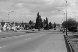
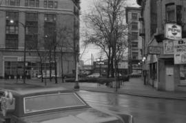
Part of City of Vancouver fonds
Image shows 1200 block of Robson Street.
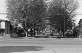
Part of City of Vancouver fonds
Image shows 1200 block of Robson Street.
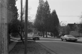
![[View of East] 14th [Avenue at] Pr[ince] Albert [Street]](/uploads/r/null/0/1/010770a09e6b951038e7dad4c2ce27438a83fb7350925f78117330ce85476fd0/94ceafce-9318-4281-b19c-84263016beee-A59118_142.jpg)
[View of East] 14th [Avenue at] Pr[ince] Albert [Street]
Part of City of Vancouver fonds
Photograph also shows houses along East 14th Avenue
![[View of the] 300 block Railway [Street]](/uploads/r/null/5/a/5ace8d71bcf997ec706d0ebe80604d0a8f7ba3edc8c1bc1de3526310684f5af6/6ca377c9-3602-4c83-a634-94701e6192af-A59192_142.jpg)
[View of the] 300 block Railway [Street]
Part of City of Vancouver fonds
![Strath[cona] Rehab[ilitation]](/uploads/r/null/0/2/02b1fed48044b74102e9925a7d95d4e41c852514c6df4fa62c81951fda863407/96950589-6fda-44af-b35b-66aab9e359d9-A59208_142.jpg)
Part of City of Vancouver fonds
Photograph shows houses and apartment buildings on Jackson Avenue and Union Street looking south to Prior.
![[Cordova Street looking west at Jackson Avenue.]](/uploads/r/null/7/b/7b6818d1a76e50216589304905b401c5dedf6da81e2e67f846e8bdbf8f7ab8c7/ae00d516-b739-47f5-b32a-672eb41756a5-A59214_142.jpg)
[Cordova Street looking west at Jackson Avenue.]
Part of City of Vancouver fonds
![Shorepine [Walk]](/uploads/r/null/7/1/71bf9a13adf952a3536edc91da0a9a8b24e934b51afd127077c90f184d41e638/3f934b51-6a29-4509-ad2b-5302707018bd-A59364_142.jpg)
Part of City of Vancouver fonds
![[Western facing view of Powell Street]](/uploads/r/null/3/5/354a5b4cb820ea3e7ff033b58bcd50c763ad8bea52b057371125d56d7b8ce312/f12dd2a8-5cbd-4b41-adff-54eae1eff23c-A59642_142.jpg)
[Western facing view of Powell Street]
Part of City of Vancouver fonds
Photograph also shows the Gassy Jack statue
Part of City of Vancouver fonds
East 40th Avenue, looking west (Main to Ontario), London Plane
Part of City of Vancouver fonds

East 42nd Avenue, looking northwest (Main to Ontario), London Plane
Part of City of Vancouver fonds

East 43rd Avenue, looking west (Main to Ontario), Horse Chestnut
Part of City of Vancouver fonds

Ontario Street and West 46th Avenue, looking North Catalpa and Cedar on west side
Part of City of Vancouver fonds
Ontario Street and West 45th Avenue, looking south - Cedar (same trees as frame 8A)
Part of City of Vancouver fonds
Almond Park, West 13th Avenue, street end
Part of City of Vancouver fonds
B.C. EL - R.O.W. (British Columbia Electric Railway Right-of-Way)
Part of City of Vancouver fonds
Item is a photograph showing the BC Electric Railway. Skipper's Japanese restaurant, Bank of Montreal and Gospel Mission at 331 Carrall visible.

B.C. EL - R.O.W. (British Columbia Electric Railway Right-of-Way)
Part of City of Vancouver fonds
![Davie & Granville [after heavy snowfall]](/uploads/r/null/9/5/957a5cb72e66af500c4a5348592f923ed6d5231c93ae0eb0929df0f007d44f61/6a9458e8-2283-4d5d-b455-8aa0e5367350-A16575_142.jpg)
Davie & Granville [after heavy snowfall]
Part of City of Vancouver fonds
Photograph shows Browne & Beaton Druggists (on Davie) and the M. Lester Dancing Academy.
![[Hastings and Richards after heavy snowfall]](/uploads/r/null/e/9/e9d02bd659129635b1478a4fc6e9bf0c9cd8498067eba2c1fb866a9d52e3db0d/8d97b4f0-d8ea-43e9-a1e1-bbdd77d4f1ba-A16577_142.jpg)
[Hastings and Richards after heavy snowfall]
Part of City of Vancouver fonds
Photograph shows the David Spencer Department Store.
![[600 block Hastings St. W. after heavy snowfall]](/uploads/r/null/1/e/1e87b92ddb583d44c61d56889b5e305648cf593c9a1dd564c5f68991f9d48398/5fc1063f-3fc6-43ed-835d-539dd82a3927-A16578_142.jpg)
[600 block Hastings St. W. after heavy snowfall]
Part of City of Vancouver fonds
![[Pender Street at Cambie Street, looking west]](/uploads/r/null/3/d/3d91c3d4cd2181022a308d60e8fad6da587efcfa17cc0a68527eb95c215bc009/5a8ff240-1741-4881-b137-7b3a66b98a1d-A43705_142.jpg)
[Pender Street at Cambie Street, looking west]
Part of City of Vancouver fonds
Photograph shows the Vancouver Sun sign, City Health Department building and Central Public School
![[Granville St. at Hastings St., looking south]](/uploads/r/null/a/2/a2b150fdc2d0d1091b88dcb4036e315291c2712f91faf805ab8ed329a1a56990/cd90450d-d6b2-45e1-8810-c58b313df506-A43716_142.jpg)
[Granville St. at Hastings St., looking south]
Part of City of Vancouver fonds
![[Granville St. at Hastings St., looking south]](/uploads/r/null/3/f/3f5c9c270d59846d9552f5e5c9c93dd128d30ad0698afa539c75b12d1c38afc0/93642b9d-f977-478f-9940-f53ece9cdca0-A43717_142.jpg)
[Granville St. at Hastings St., looking south]
Part of City of Vancouver fonds
![[700 E Hastings St]](/uploads/r/null/e/d/ed03592c91e746bd2bdb2f7bd19463f38d2315e8700fb0347925fabcb17aa532/ca970500-4326-4da5-bcd5-c6553ee5fda4-A43723_142.jpg)
Part of City of Vancouver fonds
Photograph shows south side of the 700 Block East Hastings Street as viewed from the north east including the Woodbine Hotel.
![[Looking north from Hastings Street along Hawkes Avenue]](/uploads/r/null/c/6/c6b7721c67508d95616838456d2e6f7fcb948b0917845c03dd2885e884026c85/090e0d28-920a-4794-bafe-7ce84481a5d2-A43725_142.jpg)
[Looking north from Hastings Street along Hawkes Avenue]
Part of City of Vancouver fonds
Photograph shows the National Harbours Board elevator
Eddington Drive, south side, from Haggart Street to Paton Street - view west
Part of City of Vancouver fonds
Photograph shows 4675 Haggart Street and 2404 and 2406 Eddington Drive

Haggart Street, east side, from 32nd Avenue north - view south
Part of City of Vancouver fonds

Puget Drive, east side, Eddington Avenue to lane south - view north
Part of City of Vancouver fonds

Slocan Street, west side, 1st to 2nd Avenues - view northwest
Part of City of Vancouver fonds
Photograph shows 2697 and 2691 East 2nd Avenue and a part of 2696 East 1st Avenue

Slocan Street, west side, 6th to 7th Avenues - view northwest
Part of City of Vancouver fonds
Photograph shows 2275 Slocan Street, 2693 East 7th Avenue and the rear of 2696 East 6th Avenue
![Abbott and Cordova [streets looking] west](/uploads/r/null/9/e/9e6ecc370bc289e5be80f2c7024a559ad55f83ec49ec64c8f3a8df89481637f7/f7d058c6-cc09-4ac7-85bf-be6f0d56c87c-A42713_142.jpg)
Abbott and Cordova [streets looking] west
Part of City of Vancouver fonds
Photograph shows Woodwards and the walkway to the parkade
![Abbott and Hastings [streets looking] east](/uploads/r/null/f/a/fa0d67515affc3ab9a0a5625d6d6d6e103e07a6f1a5d936f025bfd1d86416738/bf20e84f-2d2c-4ba3-a778-dfd77978f715-A42715_142.jpg)
Abbott and Hastings [streets looking] east
Part of City of Vancouver fonds
![Abbott and Hastings [streets looking] west](/uploads/r/null/1/a/1a3c9bdca5e9a05a681433abe9fe739bf52e86440936b967e1a49e5ea06628b0/99dd753a-1f99-4729-89d6-21b755a5eeb1-A42717_142.jpg)
Abbott and Hastings [streets looking] west
Part of City of Vancouver fonds
![Abbott and Pender [streets looking] east](/uploads/r/null/f/8/f83eaf09fec1ebf23e21a3db3691921915705e4f383ef44a5027be0102269396/3566daa7-37b0-43c3-96e2-f30d512ad817-A42719_142.jpg)
Abbott and Pender [streets looking] east
Part of City of Vancouver fonds
Photograph shows the Arco Hotel
![Abbott and Pender [streets looking] south](/uploads/r/null/b/b/bb5e90c611916f1b8ac5bbd1c7756bb79e72acbd41bf494dd418f633f3c49dca/284f1b6d-4e1e-4720-966f-571e057fc42c-A42720_142.jpg)
Abbott and Pender [streets looking] south
Part of City of Vancouver fonds
![Alder and 6th. [Avenue looking] north](/uploads/r/null/b/5/b5e8014aa997d96e6cbf92700ea83aa8dc54d72042b05322e9852ba8ceff9488/44a9a5d1-bf83-4a5b-81ab-2a25d3fa29eb-A42722_142.jpg)
Alder and 6th. [Avenue looking] north
Part of City of Vancouver fonds
![Alder [Street] and 6th [Avenue looking] south](/uploads/r/null/a/e/ae393bfbc80a207f68cd15f0f0b40ecc6636b45191de8f943d48ac6dfb55edf6/a8b1130e-2354-4236-8727-50a9e570eb1b-A42724_142.jpg)
Alder [Street] and 6th [Avenue looking] south
Part of City of Vancouver fonds
Photograph shows Mushroom Studios at 1234 West 6th Avenue
![Alma [Street]and Broadway [looking] east](/uploads/r/null/a/f/afd0dff1de21eae47f3b74fc927c36b4de2199db612635f05b427be03980332c/786e1118-45c9-4bea-8ef1-6a645e4399fe-A42727_142.jpg)
Alma [Street]and Broadway [looking] east
Part of City of Vancouver fonds
![49th Avenue and Ontario [Street] looking north](/uploads/r/null/d/f/df83d155b51e602db4f6dd973989d4d07114e358865d1a7c06238a9d5e5ecdf7/fcdc03b7-35e4-4bab-b01c-d2cc8982dbd0-A44590_142.jpg)
49th Avenue and Ontario [Street] looking north
Part of City of Vancouver fonds
![49th Avenue and Ontario [Street] looking east](/uploads/r/null/3/1/318898fbe1594d19db42b32641dc028c30e6501f4d201d7469fadc08a46f0b71/37527f69-1bf7-4fc8-bc4c-e3bdfe0a855e-A44592_142.jpg)
49th Avenue and Ontario [Street] looking east
Part of City of Vancouver fonds
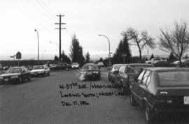
West 57th Avenue and Heather Street looking south
Part of City of Vancouver fonds
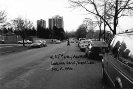
West 57th Avenue and Heather Street looking east
Part of City of Vancouver fonds

Commmercial Drive and Venables Street looking east
Part of City of Vancouver fonds
![Hemlock and Fir [Streets looking north]](/uploads/r/null/a/6/a6dd9edaf979563e05fd356f8ace4631e8b136bc6693602b7510cb564b8d4432/dd17e422-42ad-4398-b005-af8296fe0c98-A44605_142.jpg)
Hemlock and Fir [Streets looking north]
Part of City of Vancouver fonds
![Howe and Hastings [Streets looking] north](/uploads/r/null/a/0/a0237979b6172cf92beb146389349e07245295bf425a3eb3fb671dcf82ecbcf9/17403877-f6d3-4ab8-a478-bb6e3d6db5e9-A44608_142.jpg)
Howe and Hastings [Streets looking] north
Part of City of Vancouver fonds
Photograph shows the Winch Building
![Hornby and Dunsmuir [Streets looking] south](/uploads/r/null/6/2/62801964919914845404f90ed0b54c5994ed51043044d2f9560741d78e13e53d/f24fd09b-ada4-4bba-bb25-1df8c0c37598-A44609_142.jpg)
Hornby and Dunsmuir [Streets looking] south
Part of City of Vancouver fonds
![Main [Street] and 57th [Avenue looking] north](/uploads/r/null/c/2/c29f27af48ec2d278c9e297473e17f1a2272cfd640157c09b046c7a4811f139e/58ac2d81-b1c3-4a17-9428-cee17d33c70f-A44610_142.jpg)
Main [Street] and 57th [Avenue looking] north
Part of City of Vancouver fonds
![Main and Prior [Streets looking] north](/uploads/r/null/c/7/c7a7924a1c9e221e31549b3b45e6199107ca2b73b451777c2d5c6e83d531dc22/49fefe40-c4d6-4717-8db9-c3db7a7f8dcb-A44611_142.jpg)
Main and Prior [Streets looking] north
Part of City of Vancouver fonds
![Victoria [Drive] and 54th [Avenue looking] west](/uploads/r/null/d/4/d4eed7ed323bef73f03ab44bf415059eb1d6a7c4c0b6719effad66a71e4f86d9/8e012d4d-e034-4f68-99bf-323331c8d9c3-A44617_142.jpg)
Victoria [Drive] and 54th [Avenue looking] west
Part of City of Vancouver fonds
![Granville and Dunsmuir [Streets looking] north](/uploads/r/null/1/c/1ca6db6f617906d16039d0447b2ed2741f84079d9ad5845b62394b6da8a5c18d/80829671-64b4-4436-86bb-66ba7af3aba5-A43568_142.jpg)
Granville and Dunsmuir [Streets looking] north
Part of City of Vancouver fonds
![Granville and Hastings [Streets looking] east](/uploads/r/null/6/4/642a175f97ed9c7842ffd5a81488ce889fbc2c1b4781f4af48089191472e283b/c81173ed-5d33-447f-9a0b-3b46278f510a-A43576_142.jpg)
Granville and Hastings [Streets looking] east
Part of City of Vancouver fonds