
Wrigley's 1930 map of Vancouver and Lower Mainland

What the man who comes to Vancouver wants to know

Warehouse and store sites : very centrally located

Visitors map of Vancouver

Visitors map of Vancouver

Visitors map of Vancouver

Visit the souvenir shop

Vest pocket map of Vancouver : map D

Vest pocket map of Vancouver : map C

Vest pocket map of Vancouver : map B

Vancouver, Canada

Vancouver, British Columbia, south-easterly portion, formerly South Vancouver : major street plan

Vancouver, British Columbia : south-westerly portion, formerly Point Grey : major street plan

Vancouver, British Columbia : northerly portion, former City of Vancouver : major street plan

Vancouver, British Columbia

Vancouver, British Columbia

Vancouver, British Columbia

Vancouver, British Columbia
![Vancouver, B.C., the Pacific coast terminus of the C.P.R. [Canadian Pacific Railway]](/uploads/r/null/8/3/f/83fcf65f0d66d64e6357d0d647e0ea6e2fa4aae4c3d1919f952d7725b4299cda/623e750c-fbab-43b7-a496-d20b384baeb6-LEG1321_142.jpg)
Vancouver, B.C., the Pacific coast terminus of the C.P.R. [Canadian Pacific Railway]
![Vancouver, B.C., the Pacific coast terminus of the C.P.R. [Canadian Pacific Railway]](/uploads/r/null/e/2/c/e2cdc004f3cf462100ed2ef053aa6087887b3f3200917cd5fba6292afb3b2d2d/bfcde3fa-32d7-4d08-86e5-ecf70c6f8388-LEG1340_142.jpg)
Vancouver, B.C., the Pacific coast terminus of the C.P.R. [Canadian Pacific Railway]

Vancouver, B.C. street map

Vancouver, B.C. Plan showing location of water pipes, hydrants, etc. [Westminster Avenue to McLean Drive]
![Vancouver, B.C. Plan showing location of water pipes, hydrants, etc. [West End]](/uploads/r/null/0/5/05354f71931ba85b05864a2adeb3580a6365ddf962e5084f0bb51c68608364a0/3f57f512-bd27-404e-a332-e0881405c2ac-MAP72_142.jpg)
Vancouver, B.C. Plan showing location of water pipes, hydrants, etc. [West End]

Vancouver, B.C. Plan showing location of water pipes, hydrants, etc. [Victoria Drive to First Avenue to Prince Edward Street to 16th Avenue]
![Vancouver, B.C. Plan showing location of water pipes, hydrants, etc. [South Granville]](/uploads/r/null/e/a/eadb6d7351a77ac5788832abd83754cbe2966049728712aa7773bf6f2a74ff34/819e5ce5-621b-43ff-b1f5-f3bf4cac0562-MAP72_142.jpg)
Vancouver, B.C. Plan showing location of water pipes, hydrants, etc. [South Granville]
![Vancouver, B.C. Plan showing location of water pipes, hydrants, etc. [Kitsilano]](/uploads/r/null/0/e/0e33cc4d2f081f551fe6919d35ea37236a6e237a2f5927834d275556995fccfc/0f6ac1ff-8457-41f3-a386-26328c66a4b0-MAP72_142.jpg)
Vancouver, B.C. Plan showing location of water pipes, hydrants, etc. [Kitsilano]
![Vancouver, B.C. Plan showing location of water pipes, hydrants, etc. [Hastings Sunrise]](/uploads/r/null/b/c/bc8cb6a6f5ac5df0dd88a65e8a29ecceca242bde2c1b605533ad17eb835cc450/b2741291-73c5-4a98-9f41-db7fdc46fe83-MAP72_142.jpg)
Vancouver, B.C. Plan showing location of water pipes, hydrants, etc. [Hastings Sunrise]
![Vancouver, B.C. Plan showing location of water pipes, hydrants, etc. [Hastings Park area]](/uploads/r/null/0/c/0c5e2bf211ef2e6dfd7a025d620f00d0e64653f3c8080a7e2b3699fffe60e5a3/22c75a7d-7301-4578-8f71-378ca61a6b27-MAP72_142.jpg)
Vancouver, B.C. Plan showing location of water pipes, hydrants, etc. [Hastings Park area]
![Vancouver, B.C. Plan showing location of water pipes, hydrants, etc. [Grandview]](/uploads/r/null/8/8/88632d271347b57b818fde723ce9ea599c725a5190b4fb2bbb11e5f98e3809ae/3657fbb2-2cf9-4d03-b885-3836ab221252-MAP72_142.jpg)
Vancouver, B.C. Plan showing location of water pipes, hydrants, etc. [Grandview]
![Vancouver, B.C. Plan showing location of water pipes, hydrants, etc. [Fairview slopes]](/uploads/r/null/6/9/69e0d6904facfa2a814069c15122fba46fc4d8077bff76402e95484a4b13d4d8/313b8940-1e98-45d4-b077-abe0f6bee66a-MAP72_142.jpg)
Vancouver, B.C. Plan showing location of water pipes, hydrants, etc. [Fairview slopes]
![Vancouver, B.C. Plan showing location of water pipes, hydrants, etc. [Burrard Street to Gore Avenue]](/uploads/r/null/7/7/7797d041e72dece35da90eab6733a9db50a0b2115ad816578d3633a58bf31761/ebc0f54a-c23a-425c-816d-1dd268a2e4e7-MAP72_142.jpg)
Vancouver, B.C. Plan showing location of water pipes, hydrants, etc. [Burrard Street to Gore Avenue]

Vancouver, B.C. city map : street index to Vancouver map, detail map of Downtown Vancouver, and tourist attractions

Vancouver, B.C. 1890 : built-on area
![[Vancouver, B.C. : district lots]](/uploads/r/null/4/a/4a5c15633319c3754d3aa0cc525470bfebcf5a98ad8caeedf44b777194f300bd/2f055d65-47f7-4679-bb91-66b8f1843d2f-MAP531_142.jpg)
[Vancouver, B.C. : district lots]

Vancouver South, British Columbia

Vancouver sheet, British Columbia

Vancouver parks
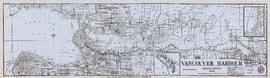
Vancouver Harbour, British Columbia, 1945

Vancouver Harbour, British Columbia, 1932

Vancouver downtown property map
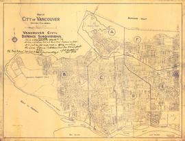
Vancouver civil defense subdivisions

Vancouver city and suburban lines

Vancouver City : plan of Subdivision of lot 301, Group 1, New Westminster District

Vancouver and Northern Railway, 1908

Vancouver : urban growth, 1865-1970

Vancouver - the third largest city of the dominion, and Canada's chief Pacific port

Vancouver : as seen from space : vue de l'espace

Vancouver

Vancouver

Transit routes in downtown area Vancouver, B.C. effective July 18, 1952