Our house : Mount Pleasant Neighbourhood House newsletter
- AM1519-: PAM 1993-52
- Item
- 1993
2306 results with digital objects Show results with digital objects
Our house : Mount Pleasant Neighbourhood House newsletter
Mount Pleasant telephone business directory
From Cambie to Clark : a look at Mount Pleasant, past and present
Item is a collection of research papers by students from the Humanities Department, Vancouver Community College.
From Cambie to Clark: a look at Mount Pleasant
Item is a collection of research papers by students from Vancouver Community College.
Guide to the early history and development of Brewery Creek Basin
Item includes maps of early trails, streams, industries.
It's the main event on Main Street
Item is a portfolio containing facts on the building and handbills advertising forthcoming activities.
Item is a proposal to renovate and restore Vancouver landmark Postal Station C.
Mount Pleasant : a neighbourhood history
Item contains information on early homes, original transportation routes through the area, and industrial encroachment, and includes a bibliography.
Item is a report prepared by the Mount Pleasant Area Council and Ratepayers' Association regarding the creation of the new Guelph Park.
Mount Pleasant Housing Society financial statements

Project 2, area "h" and part of "b" : condition of buildings
Part of City of Vancouver fonds
Item is a map showing the conditions of buildings (ranging from very good to very poor) in area "a" and part of area "b" in project 2. The map has been annotated to highlite part of the boundary around sub-area 9, as well as the southern portion of the sub-area. The significance of these annotations is not known.

Project 2, area "h" and part of "b" : plan of redevelopment
Part of City of Vancouver fonds
Item is a map showing boundaries of redevelopment areas "b" and "h", boundaries of project 2 clearance for areas 8 and 9, in project 2, proposed land use, new streets and lanes, sites in project 2 not to be acquired and buildings in project 2 to be retained.

Project 2, area "h" and part of "b" : existing gas, electricity and telephone
Part of City of Vancouver fonds
Item is a map showing the gas lines, the electricity lines, the telephone lines, the boundaries of redevelopment for areas "b" and "h" and the boundaries of project clearance for areas 8 and 9 in redevelopment project 2.

Project 2, area "h" and part of "b" : existing utilities, water and sewer
Part of City of Vancouver fonds
Item is a map showing the water lines, the sewer lines, the direction of sewer flow, the boundaries of redevelopment for areas "b" and "h" and the boundaries of project clearance for areas 8 and 9 in redevelopment project 2.

Project 2, area "h" and part of "b" : pavements, curbs and sidewalks
Part of City of Vancouver fonds
Item is a map showing the types of pavement, the curbs and gutters, the sidewalks, the boundaries of redevelopment for areas "b" and "h" and the boundaries of project clearance for areas 8 and 9 for redevelopment project 2.

Project 2, area "h" and part of "b" : condition of buildings
Part of City of Vancouver fonds
Item is a map showing the condition of buildings (ranging from very good to very poor), the boundaries of redevelopment for areas "b" and "h" and the boundaries of project clearance for areas 8 and 9 for redevelopment proct 2.

Project 2 area "h" and part of "b" : identification plan
Part of City of Vancouver fonds
Item is a map created to show the boundaries of redevelopment areas "b" and "h" in Project 2 and Project 2 clearance areas 8 & 9. The map also shows City-owned property, Adjacent lots in same ownership, as well as property, streets and lanes be acquired for the project. The portion of the City depicted in the map is the area between Main Street and Clark Drive and between Evans Avenue and 10th Avenue (D.L.200, D.L. 264A, D.L. 301, and D.L. 2037).
![Contour plan 220a [Mt. Pleasant]](/uploads/r/null/b/d/bd5c7afeea1a507ba6bc282b904c55c40d1119da939738b1911ba9fd99e6bd21/21ae5b59-321b-4488-bdc6-e782f391b8ea-MAP690_142.jpg)
Contour plan 220a [Mt. Pleasant]
Part of City of Vancouver fonds
Item is a map showing the topography of the area south of False Creek to 15th Avenue in the south and from Glen Drive in the east to Bridge Street (now Cambie Street) in the west.

Public Convenience to be erected at Kingsway & Broadway
Part of City of Vancouver fonds
Item is an architectural drawings depicting a design for proposed public toilets. The drawing includes a floor plan, multiple exterior elevations, and the site plan.
Vancouver (B.C.). Building Department

Proposed convenience at Kingsway & Main St.
Part of City of Vancouver fonds
Item is an architectural drawing of an underground public toilet facility. Drawing includes pans and cross-sections.
Vancouver (B.C.). Engineer's Office

Part of City of Vancouver Archives technical and cartographic drawing collection
Item is a map showing the location of water pipes and hydrants for the area from Victoria Drive to False Creek to Prince Edward Street to 16th Avenue (D.L. 264A). Pipes and hydrants are shown in various coloured inks to indicate date of installation.
Vancouver (B.C.). Water Works Department
![Vancouver, B.C. Plan showing location of water pipes, hydrants, etc. [Fairview slopes]](/uploads/r/null/6/9/69e0d6904facfa2a814069c15122fba46fc4d8077bff76402e95484a4b13d4d8/313b8940-1e98-45d4-b077-abe0f6bee66a-MAP72_142.jpg)
Vancouver, B.C. Plan showing location of water pipes, hydrants, etc. [Fairview slopes]
Part of City of Vancouver Archives technical and cartographic drawing collection
Item is a map showing the location of water pipes and hydrants for the area bounded by Scotia Street, False Creek, Spruce Street and Tenth Avenue (D.L. 526, D.L. 302 and D.L. 200). Block 6 in D.L. 200 was covered by an overlay depicting a later sub-division. Pipes and hydrants are shown in various coloured inks to indicate installation date. Annotations have been drawn on a base map that was part of a larger map.
Vancouver (B.C.). Water Works Department

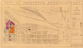
City of Vancouver redevelopment : project 2, area "H" and part of "B" : identification plan
Part of City of Vancouver fonds
Item is a map showing boundaries of clearance areas and ownership of property included in the acquisition program. Map has been annotated to show a possible amendment to the clearance area boundaries and a proposed widening of Scotia Street. Base map shows building outlines and topographic contour lines, and covers the area bounded by Main Street, Clark Drive, Terminal Avenue, and Broadway
Part of City of Vancouver fonds
Item is a map showing boundaries of redevelopment and clearance areas, proposed land use, new streets and lanes, sites not to be acquired, and buildings to be retained in project 2. Map has been annotated with colour indicating land use and a proposed widening of Scotia Street. Base map shows building outlines and topographic contour lines, and covers the area bounded by Main Street, Clark Drive, Terminal Avenue, and Broadway

Part of City of Vancouver fonds
Item is a map annotated to show the boundaries of Project no. 2 areas 8 and 9. Area 8 corresponds roughly to the area bounded by Scotia Street, Brunswick Street, 2nd Avenue, and 8th Avenue. Area 9 corresponds roughly to the area bounded by Guelph Street, Fraser Street, 5th Avenue, and 7th Avenue. Base map is a reproduction of an aerial photograph showing the area bounded by Main Street, Clark Drive, Terminal Avenue, and Broadway.

Urban renewal scheme 3 : Mt. Pleasant 2 : conditions of non-residential building
Part of City of Vancouver fonds
Item is a map annotated to show condition of non-residential buildings in the area bounded by Scotia Street, Clark Drive, Great Northern Way, and Broadway. Base map shows streets, building outlines, and topographical contour lines.

Urban renewal scheme 3 : Mt. Pleasant 2 : conditions of residential building
Part of City of Vancouver fonds
Item is a map annotated to show condition of residential buildings in the area bounded by Scotia Street, Clark Drive, Great Northern Way, and Broadway. Base map shows streets, building outlines, and topographical contour lines.

Urban renewal scheme 3 : Mt. Pleasant 2 : apartment development
Part of City of Vancouver fonds
Item is a map annotated to show dates of construction of apartment buildings in the area bounded by Scotia Street, Clark Drive, Great Northern Way, and Broadway. Base map shows streets, building outlines, and topographical contour lines.

Urban renewal scheme 3 : Mt. Pleasant 2 : existing land use
Part of City of Vancouver fonds
Item is a map annotated to show types of land use in the area bounded by Scotia Street, Clark Drive, Great Northern Way, and Broadway. Base map shows streets, building outlines, and topographical contour lines.
![Garbage landfill - Old pictures [31 of 31]](/uploads/r/null/e/c/ec58eeb7be7b665555ef7fe7e31a2f6279d478f0dd1b602b9cb0e4497e1823a0/46779ce3-de32-407b-b480-32b4111db799-A69141_142.jpg)
Garbage landfill - Old pictures [31 of 31]
Part of City of Vancouver fonds
Item is a photograph showing the former City dump site at the China Creek park area.
![Garbage landfill - Old pictures [11 of 31]](/uploads/r/null/5/1/51b55b6e59c2a514670b4dc3de2f2e0c39304b23ff9b09be4c16885b9f6f0cf7/6917c07e-f0c3-44ed-9022-d02e589a8cbb-A66345_142.jpg)
Garbage landfill - Old pictures [11 of 31]
Part of City of Vancouver fonds
Item is a photograph showing the former City dump site at the China Creek park area.
![Garbage landfill - Old pictures [10 of 31]](/uploads/r/null/8/5/85376a196eb8953473fd8b7aa51cfea56ad0e1027bf81d21ddf725dd758d359d/9c6df894-addb-4b63-beda-ccc08692a63b-A66344_142.jpg)
Garbage landfill - Old pictures [10 of 31]
Part of City of Vancouver fonds
Item is a photograph showing the former City dump site at the China Creek park area.
![Garbage landfill - Old pictures [9 of 31]](/uploads/r/null/9/4/94fb11917aad0449cdbc95be0775314fca7563b96e5d5e2a7b957887a89f9025/aecb037f-1613-461c-955d-12289359846d-A66343_142.jpg)
Garbage landfill - Old pictures [9 of 31]
Part of City of Vancouver fonds
Item is a photograph showing the former City dump site at the China Creek park area.
![Garbage landfill - Old pictures [8 of 31]](/uploads/r/null/8/9/89ce2feb6a90009a9ab06c6b7acf119aa58cee7b728898e1a491c5b172cbcaca/50b78bb8-0f46-4e53-ab93-58b104a96791-A66342_142.jpg)
Garbage landfill - Old pictures [8 of 31]
Part of City of Vancouver fonds
Item is a photograph showing the former City dump site at the China Creek park area.
![Garbage landfill - Old pictures [7 of 31]](/uploads/r/null/0/3/037966d3a480af8424da9a1074db4e1880d14c9ede6d18349b6e9ac0e302292e/824b6bec-79e8-44d6-b681-4e7505ba7055-A66341_142.jpg)
Garbage landfill - Old pictures [7 of 31]
Part of City of Vancouver fonds
Item is a photograph showing the former City dump site at the China Creek park area.
![Garbage landfill - Old pictures [6 of 31]](/uploads/r/null/2/c/2c7449d52c703aefdd3555e806652c4fd424bde88d2e97dc0c7ec730ac624405/211a505d-59cf-4c5d-a4e6-8b83cc27e299-A66340_142.jpg)
Garbage landfill - Old pictures [6 of 31]
Part of City of Vancouver fonds
Item is a photograph showing the former City dump site at the China Creek park area.
![Garbage landfill - Old pictures [5 of 31]](/uploads/r/null/c/1/c1ceb137beb8928bd7f7b521e56630c42adb798000ac8c51bd08854db62ded65/4a798901-45fe-4299-87aa-ca36371c4397-A66339_142.jpg)
Garbage landfill - Old pictures [5 of 31]
Part of City of Vancouver fonds
Item is a photograph showing the former City dump site at the China Creek park area.
![Garbage landfill - Old pictures [4 of 31]](/uploads/r/null/b/9/b94bff5190db17d08ae01c0041ce3774bb9a08f2b9291ca1ddf03063c148c27e/18f9ccf3-2a16-4982-9906-fb91edd129a7-A66338_142.jpg)
Garbage landfill - Old pictures [4 of 31]
Part of City of Vancouver fonds
Item is a photograph showing the former City dump site at the China Creek park area.
![Garbage landfill - Old pictures [3 of 31]](/uploads/r/null/1/f/1f1cb63a4c09b13221d2994d99285a5fb79adaf5e3aa7e93f048b2a9ab68acd7/76544567-3db2-4348-9690-33b6f096f10d-A66337_142.jpg)
Garbage landfill - Old pictures [3 of 31]
Part of City of Vancouver fonds
Item is a photograph showing the former City dump site at the China Creek park area.

Mayor G. G. McGeer memorial bust - side
Part of City of Vancouver fonds

Mayor G. G. McGeer memorial bust - front
Part of City of Vancouver fonds

Captain George Vancouver monument - rear
Part of City of Vancouver fonds

Captain George Vancouver monument - tablet detail
Part of City of Vancouver fonds

Captain George Vancouver monument
Part of City of Vancouver fonds

Part of City of Vancouver fonds

Part of City of Vancouver fonds
Part of City of Vancouver fonds

Part of City of Vancouver fonds

Part of City of Vancouver fonds

Part of City of Vancouver fonds