Print preview Close

Showing 161 results

Archival description
Vancouver (B.C.). Office of the City Engineer Parks
Print preview View:

159 results with digital objects Show results with digital objects

Sheet 10 : Earles Street to Boundary Road and Fortieth Avenue to Fiftieth Avenue

Item is a section showing the area from Carlton Street to Boundary Road and Fortieth Avenue to Fiftieth Avenue. Includes streets, roads, blocks, lots, legal descriptions, parks and schools. Map is hand coloured to show tax sale property for sale, property with no water, street widening and drainage, replotting, reserved land for schools, reserved land for parks, sundry land, capital assets not including schools and parks, schools, and parks, as applicable.

Vancouver (B.C.). Office of the City Engineer

Sheet 10 : Clark Drive to Slocan Street and waterfront to Triumph Street

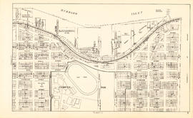
Item is a section showing the area from Clark Drive to Slocan Street and aterfront to Triumph Street. Includes streets and roads, blocks, lots, legal descriptions, railways, parks, boys' detention home and businesses along the waterfront. The Town of Hastings is indicated on the map.

Vancouver (B.C.). Office of the City Engineer

Sheet 10 : Clark Drive to Slocan Street and waterfront to Triumph Street

Item is a section showing the area from Clark Drive to Slocan Street and waterfront to Triumph Street. Includes streets and roads, blocks, lots, legal descriptions, railways, parks, boys' detention home and businesses along the waterfront. The Town of Hastings is indicated on the map.

Vancouver (B.C.). Office of the City Engineer

Sheet 10 : Clark Drive to Slocan Street and Burrard Inlet to Triumph Street

Item is a section showing the area from Clark Drive to Slocan Street and aterfront to Triumph Street. Includes streets and roads, blocks, lots, legal descriptions, railways, parks, boys' detention home and businesses along the waterfront. The Town of Hastings is indicated on the map. Map is hand coloured to show tax sale property for sale, property with no water, street widening and drainage, replotting, reserved land for schools, reserved land for parks, sundry land, capital assets not including schools and parks, schools, and parks, as applicable.

Vancouver (B.C.). Office of the City Engineer

Sheet 1: Slocan Street to Boundary Road and Triumph Street to Burrard Inlet

Item is a section showing the area bound by Slocan Street, Boundary Road, Triumph Street and the waterfront. Includes streets, roads, railways, blocks, lots, legal descriptions, quit claims, leases, parks and businesses along the waterfront.

Vancouver (B.C.). Office of the City Engineer

Sheet 1 : Slocan Street to Boundary Road and Triumph Street to Burrard Inlet

Item is a section showing the area bound by Slocan Street, Boundary Road, Triumph Street and the waterfront. Includes streets, roads, railways, blocks, lots, legal descriptions, quit claims, leases, parks and businesses along the waterfront. Section is annotated in colour to show tax sale property for sale, property with no water, street widening and drainage, replotting, reserved land for schools, reserved land for parks, sundry land, capital assets not including schools and parks, schools, and parks, as applicable.

Vancouver (B.C.). Office of the City Engineer

Sheet 1 : Cambie Street to Carolina Street and Sixteenth Avenue to Twenty-eighth Avenue

Item is a section showing the area from Cambie Street to Carolina Street and Sixteenth Avenue to Twenty-eighth Avenue. Includes streets, roads, blocks, lots, legal descriptions, parks, nurseries and schools. Map is hand coloured to show tax sale property for sale, property with no water, street widening and drainage, replotting, reserved land for schools, reserved land for parks, sundry land, capital assets not including schools and parks, schools, and parks, as applicable.

Vancouver (B.C.). Office of the City Engineer

City of Vancouver, Vancouver, British Columbia : sectional maps

File consists of three maps of Vancouver: an index to the sectional map sheets, a plan of District Lots in Vancouver, and a sectional map in 62 sheets. The sectional map sheets show streets and roads, blocks, lots, legal descriptions, railways, parks, schools, hospital, cemetery, golf courses, retirement homes, and some businesses.

Vancouver (B.C.). Office of the City Engineer

Results 151 to 161 of 161