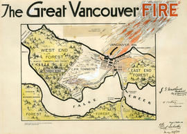
Showing 64 results

Archival description
Matthews, James Skitt, Major
Print preview View:

14 results with digital objects Show results with digital objects

It might have been Albert City, 1858, New Georgia 1792 : it was Granville, 1870, British Columbia, 1871 : it is Vancouver, 1886, British Columbia, 1871 : it is Vancouver, 1886, Canada, 1867

Item is a map compiled and drawn by J.S. Matthews, City Archivist showing historic place names of Vancouver and the North Shore and listing some historic Burnaby names. A note in the bottom left hand corner reads: "Memorada. The precise location of "Albert City" is unknown, Narveaz was first; 150 years passed before his name was given to a landmark. His vessel's name "Santa Saturnina" has never been applied to anything at all."

The founders of Vancouver, 1886 : our city is their monument

Item is a booklet commemorating the founding of Vancouver, including a chronology of the incorporation process, a brief description of the first election and first council meeting, and a list of the 125 names included on the petition for incorporation. Also includes notes from the seventieth anniversary dinner held at the Stanley Park Pavilion for all surviving pioneers and a list of notable pioneer guests.

Conversations with Khahtsahlano, 1932-1954 : conversations with August Jack Khahtsahlano, born at Snauq, False Creek Indian Reserve, circa 1877, son of Khaytulk and grandson of Chief Khahtsahlanogh.

Publication consists of text comprised of transcribed conversations between August Khatsahlano and J. S. Matthews that took place over the period 1932 to 1954. These visits were transcribed and organized into this publication by Matthews, who also augmented the text with various maps, drawings, and photographs. This additional material was either created or collected by Matthews.

Thomas Sentell fonds

  • AM275
  • Fonds
  • 1936-1993

Fonds consists of incoming correspondence from Thomas Braidwood of B.C. Drugs Limited writing to the overseas Sentell who was serving in the Royal Canadian Engineers (1942-1945) and J.S. Matthews (1938-1964). Also included news clippings (1946-1993), records (1936, 1986), and copies of Sentell's drawings (1937-1938).

Sentell, Thomas Frederick

Interpretation

The item is a table of place names shown on map 56.01; Indian villages and landmarks, Burrard Inlet and English Bay, before the whiteman came. The table gives First Nations names and their approximate english meaning, or the European name given to the same location.

False Creek Indian Reserve, Burrard Inlet, B.C.

Map is a plan of Kitsilano Point showing the area currently known as Kitsilano Beach and Vanier Park. The map shows in detail the land designated as the Kitsilano Indian Reserve, including the location of the First Nations village on False Creek and the older village of Snauq. Indicated are the boundaries of the original reserve as constituted prior to Confederation, and the addition made by the Joint Commission on 15th June 1877. The map shows the location of First Nations homes and their owners as well as orchards, hops growing area, and cemetery; a legend on the right side of the map provides further explanation. Map also shows the location of the Canadian Pacific right of way, Tait's Mill, the Third Avenue Bridge, Sam Greer's house and garden on what is now known as Kitsilano Beach, as well as creeks and other physical characteristics of the land.

[Draft map of Indian villages and landmarks, Burrard Inlet and English Bay, before the whiteman came]

The map is a draft of MAP 56.01, "Indian villages and landmarks, Burrard Inlet and English Bay, before the whiteman came." It shows the geographic area bounded by the north shore of Burrard Inlet, the Freaser River, Point Atkinson, and the Burrard Inlet Second Narrows. Shown on the map are locations of First Nations and European settlements, streams, coastal features, and inland vegitation. Physical features are labeled using both First Nations and European place names.

Draft map of Indian villages and landmarks, Burrard Inlet and English Bay, before the whiteman came

The map is a draft of map 56.01, "Indian villages and landmarks, Burrard Inlet and English Bay, before the whiteman came." It shows the geographic area bounded by the north shore of Burrard Inlet, the Fraser River, Point Atkinson, and the Burrard Inlet Second Narrows. Shown on the map are coastal sites labeled with First Nations place names.

Results 1 to 50 of 64