Zoning map : City of Vancouver, British Columbia [verso]
Zoning map : City of Vancouver, British Columbia [front side]
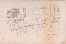
Zoning map : City of Vancouver, British Columbia [verso]
Zoning map : City of Vancouver, British Columbia [front side]
Commodities shipped overseas through Port of Vancouver
Port of Vancouver water-borne imports
Port of Vancouver water-borne exports
Proposed development of waterfront. South shore Burrard Inlet
Vancouver harbour potential wharfage and trackage areas
Present use. Vancouver harbour
Proposed elevated waterfront roadway
Greater Vancouver British Columbia Railroads and Harbour
Preliminary report on civic centre
Historical park development
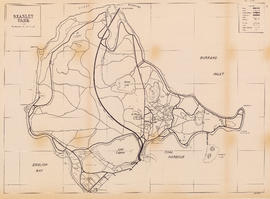
Stanley Park
Downtown peninsula
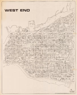
West End
West End
West End local area
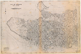
City of Vancouver, B.C.
City of Vancouver, B.C. : curb ramp locations
City of Vancouver : 1986 census of Canada
City of Vancouver, British Columbia : 1981 census of Canada
Downtown peninsula - Vancouver, B.C. : contour lines at 10 foot intervals, datum line - 100
North-East Burnaby Study, revised Simon Fraser townsite plan : 1967 City of Vancouver alternative proposals
Zoning map : City of Vancouver, British Columbia
Zoning map : City of Vancouver, British Columbia
Zoning District Plan : City of Vancouver, British Columbia
Zoning Map: City of Vancouver, British Columbia
Zoning Map: City of Vancouver, British Columbia
Zoning Map: City of Vancouver, British Columbia
Zoning Map: City of Vancouver, British Columbia
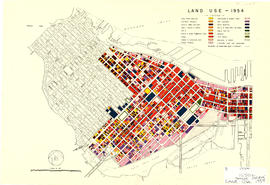
Land use - 1954
Existing service stations, retail shopping centres and commercial zoning : a basis for regulating location of service stations
City of Vancouver : land use 1984
Official Regional Plan : proposed amendments within the City of Vancouver
Map of City of Vancouver showing schools, parks, community centres, libraries, health units
Sectional map of Vancouver showing streets, block and lot outlines, and building perimeters : Map 90 : Iona Island to Wood Island and Celtic Avenue to Sea Island
Sectional map of Vancouver showing streets, block and lot outlines, and building perimeters : Map 89 : Area west of Angus Drive to Barnard Street and S.W. Marine Drive to the North Arm of the Fraser River
Sectional map of Vancouver showing streets, block and lot outlines, and building perimeters : Map 88 : MacDonald Street to Laburnum Street/Angus Drive and 57th Avenue to the North Arm of the Fraser River
Sectional map of Vancouver showing streets, block and lot outlines, and building perimeters : Map 87 : Barnard Street to Heather Street and 75th Avenue/Kent Avenue South to the North Arm of the Fraser River
Sectional map of Vancouver showing streets, block and lot outlines, and building perimeters : Map 86 : Angus Drive to Laurel Street and 68th Avenue/67th Avenue to the North Arm of the Fraser River
Sectional map of Vancouver showing streets, block and lot outlines, and building perimeters : Map 85 : Laburnum Street to Fremlin Street and 57th Avenue to 68th Avenue/67th Avenue
Sectional map of Vancouver showing streets, block and lot outlines, and building perimeters : Map 84 : Laurel Street to Main Street and 67th Avenue/S.W. Marine Drive to the North Fork of the North Arm of the Fraser River
Sectional map of Vancouver showing streets, block and lot outlines, and building perimeters : Map 83 : Fremlin Street to Main Street and 57th Avenue to 67th Avenue/S.W. Marine Drive
Sectional map of Vancouver showing streets, block and lot outlines, and building perimeters : Map 82 : Main Street to Crompton Street and S.E. Marine Drive to the North Fork of the North Arm of the Fraser River
Sectional map of Vancouver showing streets, block and lot outlines, and building perimeters : Map 81 : Main Street to Inverness Street and 57th Avenue to S.E. Marine Drive
Sectional map of Vancouver showing streets, block and lot outlines, and building perimeters : Map 80 : Inverness Street to Gladstone Street/Nanaimo Street and 61st Avenue to the North Fork of the North Arm of the Fraser River
Sectional map of Vancouver showing streets, block and lot outlines, and building perimeters : Map 79 : Gladstone Street/Nanaimo Street to Kerr Street and Bobolink Avenue to the North Arm of the Fraser River
Sectional map of Vancouver showing streets, block and lot outlines, and building perimeters : Map 78 : Kerr Street to Boundary Road and S.E. Marine Drive to the North Arm of the Fraser River
![Zoning map : City of Vancouver, British Columbia [verso]](/uploads/r/null/0/c/0c28eac99426ce4ba64e4dfd48e45082c152014d6316047710a9601978663e70/d7052696-ccd5-4643-98d6-5e29205d9903-PD2100_142.jpg)
![Zoning map : City of Vancouver, British Columbia [front side]](/uploads/r/null/c/6/c61049cff53ecb5ec71dcc9b9de797d324126efb9c99b5eb62ea91c42d3b6842/743a013c-68a0-418f-8c6a-fd776aa116ef-PD2100_142.jpg)
![Zoning map : City of Vancouver, British Columbia [verso]](/uploads/r/null/8/e/8e44e80ba947d96b0a59a2bf4a48b60a1421fd04ba8480ddd13d7d13d0702e36/6b887f4f-8b76-48e2-866b-15499f569972-PD2100_142.jpg)
![Zoning map : City of Vancouver, British Columbia [front side]](/uploads/r/null/d/f/df6282b6329852b263c3d33e20d903e4289eec05fde21bd58597f62d30789dde/225b2095-0e64-4986-878c-fd99eb6e1f18-PD2100_142.jpg)