![[Aerial view looking east over Stanley Park, Coal Harbour and Burrard Inlet]](/uploads/r/null/d/0/d02fee694c486ac2accdeefb505d0dae5fcb42789ef16de49322d845e3c04b44/be8c34ce-7c09-4c0e-a395-f083c9134080-A43248_142.jpg)
[Aerial view looking east over Stanley Park, Coal Harbour and Burrard Inlet]
- AM54-S4-: Van Sc P66
- Item
- [ca. 1926]
Part of Major Matthews collection
Oblique view
[Aerial view looking east over Stanley Park, Coal Harbour and Burrard Inlet]
Part of Major Matthews collection
Oblique view
![[Aerial view of Mount Pleasant, South Strathcona and Kensington-Cedar Cottage]](/uploads/r/null/7/5/75ea991fe8319eaffda79b314cbf20e281e35eb2cd8a89eaa898b492242d6282/05f856f3-0a45-41eb-94dc-46cb9d2f7ecf-A63348_142.jpg)
[Aerial view of Mount Pleasant, South Strathcona and Kensington-Cedar Cottage]
Part of Major Matthews collection
Photograph shows aerial view of the east end of False Creek, Thornton Park, Great Northern Railway and Canadian National Railway yards, Mount Pleasant, Strathcona, Grandview-Woodland, Trout Lake, Kingsway, Vancouver Technical School grounds, Renfrew playing fields, John Hendry Park, British Columbia Electric Railway Right of Way, Clark Park, Grandview Highway South, Great Northern Railway.
![[Aerial view of Vancouver]](/uploads/r/null/b/9/b973b9a4143a5316b02e728c35d99e383f27a3db21d8e20aa7bbb459780243bc/3ff38b56-6b36-4c17-bce1-329c97459d29-A66598_142.jpg)
Part of Major Matthews collection
Photograph shows Kitsilano, Kits Point, Kitsilano Beach, R.C.A.F. Equipment Depot, Kitsilano Pool, Burrard Bridge, C.P.R. Kitsilano Trestle, Granville Island, Granville Bridge, Cambie Bridge, False Creek, C.P.R. False Creek Yards, West End, Yaletown, Arbutus Ridge, Shaughnessy, South Cambie, Fairview, Mount Pleasant, Little Mountain Reservoir, Connaught Park, Quilchena Golf Course, Douglas Park, Shaughnessy Heights Golf Course, Queen Elizabeth Park, Royal Canadian Mounted Police Barracks, Shaughnessy Military Hospital, Hillcrest Park, Robertson & Hacket Sawmill, City Yard, West Coast Ship Builders and Athletic Park.
![[Aerial view of West Point Grey, Kitsilano, Dunbar - Southlands and University Endowment Lands]](/uploads/r/null/0/8/089d213e9a81ca689130a244122a86972e068c9b01ab994922a88072ac881121/1ed71859-c157-4686-82db-e3483cd4b877-A66599_142.jpg)
[Aerial view of West Point Grey, Kitsilano, Dunbar - Southlands and University Endowment Lands]
Part of Major Matthews collection
Photograph shows the south Slope of English Bay, Spanish Banks, Locarno Beach Park, Jericho Beach, R.C.A.F. Jericho Air Station, Kitsilano pool, Connaught Park and Kitsilano Beach Park, Caldecott Park, Quilchena Golf Course, School for Deaf and Blind and Quesnel Park.
![[Aerial view of Burrard Inlet, Hastings-Sunrise, Burnaby and the District of North Vancouver]](/uploads/r/null/d/f/df7e11c97173ce0473c454f0a01569b641972f6efdc12bf192edbc42119542d6/6d72f89b-9b55-48c4-bef6-04eb2137f1d3-A66600_142.jpg)
[Aerial view of Burrard Inlet, Hastings-Sunrise, Burnaby and the District of North Vancouver]
Part of Major Matthews collection
Photograph shows Exhibition Park and P.N.E. Golf Course, Second Narrows Bridge, New Brighton Park, Callister Park, Burrard Inlet, Lynn Creek, Lynn Park, Seymour Creek, Vancouver Harbour Commissioners Railway, Inspected Shingles Ltd., Cascade Rock and Gravel Co. Ltd., Canadian Shingle Co. Ltd. (Capilano Timber Co. Ltd.), Alberta Pool Elevator, Columbia Grain Elevator Co. Ltd., Canadian Pacific Railway, Girls Industrial School and Old Peoples Home sites.
![[The C.P.R. Park at the corner of Georgia Street and Granville Street]](/uploads/r/null/d/7/d795a97face73a83c2531cf51175d92c0447616a644e41a6e8f91ce1df9ac547/e543c340-8fdb-4fc5-9992-a6dca03297dd-A36999_142.jpg)
[The C.P.R. Park at the corner of Georgia Street and Granville Street]
Part of Major Matthews collection
![[View from 2596 Dundas Street of the 29th Battalion drilling in Callister Park]](/uploads/r/null/c/8/c83a4b9aeb65eba395fe0e8319d72fc7b452a7886fd8418c7585107656bdfa33/4ce2911b-3648-4dea-8e2c-4e366c878c86-A37135_142.jpg)
[View from 2596 Dundas Street of the 29th Battalion drilling in Callister Park]
Part of Major Matthews collection
![[View of Pioneer Place, corner of Carrall Street and Hastings]](/uploads/r/null/8/3/83cee3d4801654884f4b86d80714ca8988e09f94cd6e8f33eb45e126261ef9c7/f0ce6d46-0eb0-4883-8521-0fe2e4197063-A10286_142.jpg)
[View of Pioneer Place, corner of Carrall Street and Hastings]
Part of Major Matthews collection
Photograph shows the small park and businesses along West Hastings Street including the Majestic Theatre and the Army & Navy.
![[View of Pioneer Place, corner of Carrall Street and Hastings]](/uploads/r/null/7/1/7129a13ad6f67f2a3d990fd0cf849e8e04dd0e36e7d23c461bb804e103c93b92/c193dad4-aa2f-463e-b5a6-aa4e2ee02d74-A10285_142.jpg)
[View of Pioneer Place, corner of Carrall Street and Hastings]
Part of Major Matthews collection
![[View of the Lions Gate Bridge from Chaythoos, the site where Lord Stanley dedicated Stanley Park]](/uploads/r/null/2/5/253fcff959bc0024660b96f279fa727fda4a22e2fe452805bc4e79c05ebc3149/5589252a-7532-4288-8bca-20fa18c3ba36-A10268_142.jpg)
[View of the Lions Gate Bridge from Chaythoos, the site where Lord Stanley dedicated Stanley Park]
Part of Major Matthews collection
![[Stanley Park, viewed from English Bay]](/uploads/r/null/5/6/568faca829e51723935ed64071e5320eae9857bfd5589ef4d3e1785742ac3b4a/bbcbb422-80e1-4cad-9330-84ae15b2e951-A04002_142.jpg)
[Stanley Park, viewed from English Bay]
Part of Major Matthews collection
J.S. Matthews' notes with print or negative in Archives.

Part of Major Matthews collection
J.S. Matthews' notes with print or negative in Archives.

Part of Major Matthews collection
J.S. Matthews' notes with print or negative in Archives.
![[Composite view of ships and Stanley Park sites]](/uploads/r/null/3/c/3c46b96242786e4b1aad8df2b667da89143a46e55dc4a60c9541d68888ae6ac9/d6361a9b-8768-494b-911e-6f055c94677c-A03966_142.jpg)
[Composite view of ships and Stanley Park sites]
Part of Major Matthews collection
Photograph consists of a composite of four photographs showing: large tree in Stanley Park, bridge in Stanley Park, the S.S. "Beaver" on shore (Bo P124), and the "Empress of India" at Vancouver dock (Bo P 6.4).
![[Composite of three Vancouver scenes]](/uploads/r/null/6/3/63a212dcbeefd621100706d8f124b87a33a6c9b89b843c22e400d20998580f4b/0a7256b5-202a-467c-a84e-a7798851caef-A03937_142.jpg)
[Composite of three Vancouver scenes]
Part of Major Matthews collection
Photograph consists of a composite of three photographs, showing a salmon cannery, Brockton Point, and a view of Vancouver from Mount Pleasant. The images were photographed while mounted on a sheet of newspaper.
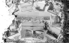
Part of Major Matthews collection
Photograph consists of various images of Vancouver, including sites in Stanley Park, boats, street scenes, a cannery, and other photographs, surrounded by foliage and fruit.
![[Boat in Burrard Inlet, near Brockton Point]](/uploads/r/null/0/c/0c2fa95b7dc1fa230d6e1536914f2653429ab4c9d5964b9720c697e3971cdba6/07ce4d85-4bef-42ff-996f-f6a284719e8d-A04014_142.jpg)
[Boat in Burrard Inlet, near Brockton Point]
Part of Major Matthews collection
J.S. Matthews' notes with print or negative in Archives.
![[Tea being spread out to dry in C.P.R. park at Granville and Georgia Streets]](/uploads/r/null/e/a/ea5109d580850cc7de7b0d1c95ecdc16c53da1cd22377840fcebf5ec89f96293/9b00d96a-5fb7-4947-aef3-46ed92d5d852-A04882_142.jpg)
[Tea being spread out to dry in C.P.R. park at Granville and Georgia Streets]
Part of Major Matthews collection
Photograph shows a customs agent sitting on a box of tea, watching Asian workers empty tea out of boxes and spread it out to dry with rakes.
![[Boats in Burrard Inlet, near Brockton Point]](/uploads/r/null/f/6/f6ab148af8419f2d34b065e701dc36facfcd9b0b2f4acfec988fe9275d477ff2/11448caf-652a-43d9-9ef9-f91b97e4aaab-A04013_142.jpg)
[Boats in Burrard Inlet, near Brockton Point]
Part of Major Matthews collection
J.S. Matthews' notes with print or negative in Archives.
![[Victory Square from Hamilton and Pender Streets]](/uploads/r/null/6/2/62b2cc793a1eeb813d57679932ab341d111fd927f214aa829d1e166ad0e48d6f/fda4a7e6-5f02-4bb2-9b79-ec6ffa0c6796-A09379_142.jpg)
[Victory Square from Hamilton and Pender Streets]
Part of Major Matthews collection
![[Victory Square from Cambie and Pender Streets]](/uploads/r/null/1/e/1eca0f5c670823e43d2017c8560b46d02a749e64590b60b2202a2ffce0b31cf4/b738e827-eef3-49b5-9ba2-763a7e2a3354-A09378_142.jpg)
[Victory Square from Cambie and Pender Streets]
Part of Major Matthews collection

Staff of Pure Milk Dairy Co. Samuel Garvin Prop. Vancouver B.C. 15/6/16
Part of Major Matthews collection
Photograph shows S. Garvin and others in an automobile among horse-drawn milk wagons and delivery men in front of a bandstand in Robson Park. The photograph also shows houses and buildings in the 500 block 13th Ave E. and the 2900 block Carolina Street.

Samuel Garvin Prop. & staff of pure Milk Dairy Co. Vancouver. B.C. June 15.1916
Part of Major Matthews collection
Photograph shows S. Garvin and other in an automobile among hore-drawn milk wagons and delivery men in front of the bandstand in Robson Park. Photograph also shows houses in the 500 block 13th Ave E, the 2900 block Carolina Street and 600 block 14th Ave E.
![[View of the Great Northern (Union) and Canadian National Stations and Thornton Park]](/uploads/r/null/3/f/3f3bf794ce9c38103d6e1f740d743b90cf54e8f2591d95f7406a69a338615147/b1609fd1-5aca-4ca5-87bc-b899b4c76130-A63485_142.jpg)
[View of the Great Northern (Union) and Canadian National Stations and Thornton Park]
Part of Major Matthews collection
Panoramic view showing the Hotel Ivanhoe, the G.N. and C.N. freight buildings and Massey-Harris Farm Implements.

Pacific National Exhibition grounds plan
Part of City of Vancouver Archives technical and cartographic drawing collection
Item is a map showing a site plan of Exhibition Park, with calculations of parking lot capacities on the Pacific National Exhibition grounds. Two areas on the map have been shaded in blue. The attached sheet lists square footages of parking lots, buildings, leases and other areas around the park.

General development plan, Exhibition Park, Vancouver, B.C.
Part of City of Vancouver Archives technical and cartographic drawing collection
Item is a map showing the Exhibition Park site, with existing buildings, proposed buildings (immediate program), proposed buildings (future program), building names and parking lot capacities.
Harland Bartholomew and Associates

Part of City of Vancouver Archives technical and cartographic drawing collection
Item is a map showing the locations of Vancouver parks.

Sheet 18 : Vivian Street to Boundary Road and Sixty-fifth Avenue to Fraser River
Part of City of Vancouver Archives technical and cartographic drawing collection
Item is a section showing the area from Vivian Street to Boundary Road and Sixty-fifth Avenue to Fraser River. Includes streets, roads and railway lines; blocks, lots and legal descriptions; and parks, schools and golf courses.
Vancouver (B.C.). Office of the City Engineer

Sheet 17 : Argyle Street to Vivian Street and Sixty-second Avenue to Kent Street
Part of City of Vancouver Archives technical and cartographic drawing collection
Item is a section showing the area from Argyle Street to Vivian Street and Sixty-second Avenue to Kent Street. Includes streets, roads, blocks, lots, legal descriptions and golf courses.
Vancouver (B.C.). Office of the City Engineer

Sheet 16 : St. George Street to Argyle Street and Fifty-eighth Avenue to Fraser River
Part of City of Vancouver Archives technical and cartographic drawing collection
Item is a section showing the area from St. George Street to Argyle Street and Fifty-eighth Avenue to the Fraser River. Includes streets, roads, blocks, lots, legal descriptions, railway lines, parks and schools.
Vancouver (B.C.). Office of the City Engineer

Sheet 15 : Ash Street to St. George Street and Fifty-eighth Avenue to Marine Drive
Part of City of Vancouver Archives technical and cartographic drawing collection
Item is a section showing the area from Ash Street to St. George Street and Fifty-eighth Avenue to Marine Drive.Includes streets, roads, blocks, lots, legal descriptions, parks and railway lines.
Vancouver (B.C.). Office of the City Engineer

Sheet 14 : Ash Street to St. George Street and Marine Drive to Fraser River
Part of City of Vancouver Archives technical and cartographic drawing collection
Item is a section showing the area from Ash Street to St. George Street and Marine Drive to Fraser River. Includes streets, roads, blocks, lots, legal descriptions, parks and railway lines.
Vancouver (B.C.). Office of the City Engineer

Sheet 13 : Fleming Street to Carlton Street and Forty-seventh Avenue to Fifty-ninth Avenue
Part of City of Vancouver Archives technical and cartographic drawing collection
Item is a section showing the area from Fleming Street to Carlton Street and Forty-seventh Avenue to Fifty-ninth Avenue. Includes streets, roads, blocks, lots, legal descriptions, parks and schools.
Vancouver (B.C.). Office of the City Engineer

Sheet 12 : Prince Edward Street to Bruce Street and Forty-seventh Avenue to Fifty-eighth Avenue
Part of City of Vancouver Archives technical and cartographic drawing collection
Item is a section showing the area from Prince Edward Street to Bruce Street and Forty-seventh Avenue to Fifty-eighth Avenue. Includes streets, roads, blocks, lots, legal descriptions, parks and schools.
Vancouver (B.C.). Office of the City Engineer

Sheet 11 : Cambie Street to St. George Street and Forty-seventh Avenue to Fifty-eighth Avenue
Part of City of Vancouver Archives technical and cartographic drawing collection
Item is a section showing the area from Cambie Street to St. George Street and Forty-seventh Avenue to Fifty-eighth Avenue. Includes streets, roads, blocks, lots, legal descriptions, golf courses, parks and schools.
Vancouver (B.C.). Office of the City Engineer

Sheet 10 : Carlton Street to Boundary Road and Fortieth Avenue to Fiftieth Avenue
Part of City of Vancouver Archives technical and cartographic drawing collection
Item is a section showing the area from Carlton Street to Boundary Road and Fortieth Avenue to Fiftieth Avenue. Includes streets, roads, blocks, lots, legal descriptions, parks and schools.
Vancouver (B.C.). Office of the City Engineer

Sheet 9 : Fleming Street to Carlton Street and Thirty-seventh Avenue to Forty-eighth Avenue
Part of City of Vancouver Archives technical and cartographic drawing collection
Item is a section showing the area from Fleming Street to Carlton Street and Thirty-seventh Avenue to Forty-eighth Avenue. Includes streets, roads, blocks, lots, legal descriptions, parks and schools.
Vancouver (B.C.). Office of the City Engineer

Sheet 8 : Prince Edward Street to Bruce Street and Thirty-fifth Avenue to Forty-seventh Avenue
Part of City of Vancouver Archives technical and cartographic drawing collection
Item is a section showing the area from Prince Edward Street to Bruce Street and Thirty-fifth Avenue to Forty-seventh Avenue. Includes streets, roads, blocks, lots, legal descriptions, and cemeteries, parks and schools.
Vancouver (B.C.). Office of the City Engineer

Sheet 7 : Cambie Street to St. George Street and Thirty-seventh Avenue to Forty-eighth Avenue
Part of City of Vancouver Archives technical and cartographic drawing collection
Item is a section showing the area from Cambie Street to St. George Street and Thirty-seventh Avenue to Forty-eighth Avenue. Includes streets, roads, blocks, lots, legal descriptions, parks, cemeteries, and schools.
Vancouver (B.C.). Office of the City Engineer

Sheet 6 : Craddock Street to Boundary Road and Twenty-ninth Avenue to Fortieth Avenue
Part of City of Vancouver Archives technical and cartographic drawing collection
Item is a section showing the area from Craddock Street to Boundary Road and Twenty-ninth Avenue to Fortieth Avenue. Includes streets, roads, blocks, lots, legal descriptions, parks. railway lines and schools.
Vancouver (B.C.). Office of the City Engineer

Sheet 5 : Dumfries Street to Fairmont Street and Twenty-seventh Avenue to Thirty-seventh Avenue
Part of City of Vancouver Archives technical and cartographic drawing collection
Item is a section showing the area from Dumfries Street to Fairmont Street and Twenty-seventh Avenue to Thirty-seventh Avenue. Includes streets, roads, blocks, lots, legal descriptions, parks, railway lines and schools.
Vancouver (B.C.). Office of the City Engineer

Sheet 4 : Prince Edward Street to Bruce Street and King Edward Avenue to Thirty-sixth Avenue
Part of City of Vancouver Archives technical and cartographic drawing collection
Item is a section showing the area from Prince Edward Street to Bruce Street and King Edward Avenue to Thirty-sixth Avenue. Map shows streets, roads, blocks, lots and legal descriptions, and the locations of parks, schools and Mountainview Cemetery.
Vancouver (B.C.). Office of the City Engineer

Sheet S.V. 3 : Cambie Street to St. George Street and Twenty-seventh Avenue to Thirty-eighth Avenue
Part of City of Vancouver Archives technical and cartographic drawing collection
Item is a section showing the area from Cambie Street to St. George Street and Twenty-seventh Avenue to Thirty-eighth Avenue. Map shows streets, roads, blocks, lots and legal descriptions and the locations of parks, schools, reservoirs and Mountainview Cemetery.
Vancouver (B.C.). Office of the City Engineer

Sheet 1 : Cambie Street to Carolina Street and Sixteenth Avenue to Twenty-eighth Avenue
Part of City of Vancouver Archives technical and cartographic drawing collection
Item is a section showing the area from Cambie Street to Carolina Street and Sixteenth Avenue to Twenty-eighth Avenue. Includes streets, roads, blocks, lots, legal descriptions, parks, nurseries and schools.
Vancouver (B.C.). Office of the City Engineer

Sheet X : Marine Drive to Ash Street and Fifty-ninth Avenue to Seventy-first Avenue
Part of City of Vancouver Archives technical and cartographic drawing collection
Item is a section showing the area from Marine Drive to Ash Street and Fifty-ninth Avenue to Seventy-first Avenue. Includes streets and roads; blocks, lots and legal descriptions; and parks and schools.
Vancouver (B.C.). Office of the City Engineer

Sheet W : Fraser River to French Street and Fifty-ninth Avenue to Seventy-first Avenue
Part of City of Vancouver Archives technical and cartographic drawing collection
Item is a section showing the area from Fraser River to French Street and Fifty-ninth Avenue to Seventy-first Avenue. Includes streets and roads; blocks, lots and legal descriptions; and parks and golf courses.
Vancouver (B.C.). Office of the City Engineer

Sheet U : Churchill Street to Cambie Street and Forty-ninth Avenue to Park Drive
Part of City of Vancouver Archives technical and cartographic drawing collection
Item is a section showing the area from Churchill Street to Cambie Street and Forty-ninth Avenue to Park Drive. Includes streets and roads; blocks, lots and legal descriptions; and parks and golf courses.
Vancouver (B.C.). Office of the City Engineer

Sheet T : Marine Crescent to Granville Street and Forty-ninth Avenue to Sixty-first Avenue
Part of City of Vancouver Archives technical and cartographic drawing collection
Item is a section showing the area from Marine Crescent to Granville Street and Forty-ninth Avenue to Sixty-first Avenue. Includes streets and roads; blocks, lots and legal descriptions; and parks and golf courses.
Vancouver (B.C.). Office of the City Engineer

Sheet P : Trafalgar Street to Granville Street and Thirty-ninth Avenue to Thirty-seventh Street
Part of City of Vancouver Archives technical and cartographic drawing collection
Item is a section showing the area from Trafalgar Street to Granville Street and Thirty-ninth Avenue to Thirty-seventh Street. Includes streets and roads; blocks, lots and legal descriptions; and parks and schools.
Vancouver (B.C.). Office of the City Engineer

Sheet O : Holland Street to Elm Street and Thirty-eighth Avenue to Forty-ninth Avenue
Part of City of Vancouver Archives technical and cartographic drawing collection
Item is a section showing the area from Holland Street to Elm Street and Thirty-eighth Avenue to Forty-ninth Avenue. Includes streets, roads and sewers; blocks, lots and legal descriptions; and golf courses, parks and schools.
Vancouver (B.C.). Office of the City Engineer