Showing 268 results
Archival description
City of Vancouver, B.C. area map : Inverness Street to Boundary Road and 32nd Avenue to 54th Avenue

One way streets : Illustrated map of Downtown Vancouver

Vancouver bicycle routes
![Sheet 1D [Boundary Road to Cambridge Street to Windermere Street to Pender Street]](/uploads/r/null/1/d/4/1d47034f04f443cd5d3bba2f8d2d21c3a21a2e6b801a5af04c074e2c3b6dd02e/7ad1a0c8-97c9-4e10-98c2-5017d74f4033-LEG1153_142.jpg)
Sheet 1D [Boundary Road to Cambridge Street to Windermere Street to Pender Street]
![Sheet 3A [Windermere Street to 5th Avenue to Slocan Street to Grandview Highway]](/uploads/r/null/c/0/8/c081ba1194af0da71e1f88ca1a7c4efd637e7ae3d846b4e9fd5d153faa656b0e/ce3a288b-01f7-491a-b5ee-59b744d23996-LEG1153_142.jpg)
Sheet 3A [Windermere Street to 5th Avenue to Slocan Street to Grandview Highway]
![Sheet 3B [Boundary Road to 5th Avenue to Windermere Street to Grandview Highway]](/uploads/r/null/c/9/c/c9c099174510121f7347c0ed2dc3f4db8a646b3846d9fcf65747209bb83b81d2/51551449-0417-479e-8467-bddbe7b574b3-LEG1153_142.jpg)
Sheet 3B [Boundary Road to 5th Avenue to Windermere Street to Grandview Highway]
![Sheet 5D [Boundary Road to 45th Avenue to Doman Street to 52nd Avenue]](/uploads/r/null/9/a/5/9a56c23cc8d5ad437bb7063cd9cf0f954bc1d67724ef20861270160771809b4c/d7777803-4376-423c-a5d5-8a44ed84aee7-LEG1153_142.jpg)
Sheet 5D [Boundary Road to 45th Avenue to Doman Street to 52nd Avenue]
![Sheet 6B [Boundary Road to 52nd Avenue to Doman Street to 61st Avenue]](/uploads/r/null/2/3/2/2320f1235e898d9e510839eb4408e0746654e3df66acd70352f78e35c1f83fe4/a427c08e-09a5-4e9f-adbd-6f81d49fe16f-LEG1153_142.jpg)
Sheet 6B [Boundary Road to 52nd Avenue to Doman Street to 61st Avenue]
![Sheet 8A [Semlin Drive to Hastings Street to Clark Drive to Charles Street]](/uploads/r/null/c/e/1/ce14d71e20eb294141c9dd954f1318d51d5f7a7cd55238a25a046162a7080d15/a477e80d-6d23-4d54-9c01-cb4ffe87796e-LEG1153_142.jpg)
Sheet 8A [Semlin Drive to Hastings Street to Clark Drive to Charles Street]
![Sheet 8B [Slocan Street to Pender Street to Semlin Drive to Charles Street]](/uploads/r/null/3/5/4/354478b1921f42f9f80b25d890823ee2c6ef900b23fe032c8504bdf3e7ae0a68/4d6f04e3-89d1-4093-8da7-9692b235a110-LEG1153_142.jpg)
Sheet 8B [Slocan Street to Pender Street to Semlin Drive to Charles Street]
![Sheet 9A [Semlin Drive to 6th Avenue to Clark Drive to 14th Avenue]](/uploads/r/null/4/b/8/4b83338cc19b64deb790aac94219d77731e8a711697a611a458656793c63ccda/f3604bbf-e839-474f-a033-6569d2f2d2e0-LEG1153_142.jpg)
Sheet 9A [Semlin Drive to 6th Avenue to Clark Drive to 14th Avenue]
![Sheet 12A [Duff Street to 53rd Avenue to Knight Street to 61st Avenue]](/uploads/r/null/6/2/6/626abd9097f522a3a00f5729e122baf25c1abca24eaebe891f16c22dc206513b/e0ee89cb-6da7-4421-88de-a697d79f3a18-LEG1153_142.jpg)
Sheet 12A [Duff Street to 53rd Avenue to Knight Street to 61st Avenue]
![Sheet 12D [Harrison Drive to 61st Avenue to Victoria Drive to SW Marine Drive]](/uploads/r/null/1/0/d/10dafbfa4cf4bf1888a863053dec25b30a177b6441646761b09f6468dee14074/e8338aff-cbd3-4f79-8072-3d661cdd1bd1-LEG1153_142.jpg)
Sheet 12D [Harrison Drive to 61st Avenue to Victoria Drive to SW Marine Drive]
![Sheet 14A [Hawks Avenue to Burrard Inlet to Main Street to Powell Street]](/uploads/r/null/e/2/8/e288aac0af2470fbe41a5a5898348a18e7de697b091d3e45ec41fa072ec287e6/3bbe6aae-c655-48cd-a519-fc20dc66b684-LEG1153_142.jpg)
Sheet 14A [Hawks Avenue to Burrard Inlet to Main Street to Powell Street]
![Sheet 17B [Knight Street to King Edward Avenue to Fraser Street to Durward Avenue]](/uploads/r/null/1/a/f/1aff8dcb09ab65378dfafeb29d7118ccc19705c70cbb15bdad682b0a0909f633/7d7ac22a-48d6-4e8e-8d72-5d4ff3e31715-LEG1153_142.jpg)
Sheet 17B [Knight Street to King Edward Avenue to Fraser Street to Durward Avenue]
![Sheet 17D [Knight Street to Durward Avenue to Fraser Street to 41st Avenue]](/uploads/r/null/6/b/9/6b937fa197e37d6f7b871772b460a37f71b63a0cb6fbbe578e2042c79e665327/9fac95fe-f944-435f-83e7-3a79eac6809b-LEG1153_142.jpg)
Sheet 17D [Knight Street to Durward Avenue to Fraser Street to 41st Avenue]
![Sheet 18A [Fraser Street to 41st Avenue to Quebec Street to 49th Avenue]](/uploads/r/null/c/8/0/c80a4237c9c4c70aad340c2fb1df174b7ecf854e10b2268e00a49c5535b69999/37febe49-c3ee-4548-9d7d-e61b05fb8c01-LEG1153_142.jpg)
Sheet 18A [Fraser Street to 41st Avenue to Quebec Street to 49th Avenue]
![Sheet 18B [Knight Street to 41st Avenue to Fraser Street to 49th Avenue]](/uploads/r/null/4/6/2/4627396b36381f103746d345ff109e8b8fe827f6171f284cca6c63ff575c8dd6/5d404355-3475-4444-8c85-f4f5fe86c9b3-LEG1153_142.jpg)
Sheet 18B [Knight Street to 41st Avenue to Fraser Street to 49th Avenue]
![Sheet 20C [Cardero Street to Nelson Street to Park Lane to English Bay]](/uploads/r/null/d/f/9/df9674e7f6e9690eb4de6a6352a2f89e4040b0a2b62edd08d8b36edc952d7d0b/e1a5c554-3bb1-46f8-b0d1-77a0c8046fb0-LEG1153_142.jpg)
Sheet 20C [Cardero Street to Nelson Street to Park Lane to English Bay]
![Sheet 21E [False Creek to Davie Street to Burrard Street to False Creek]](/uploads/r/null/a/1/7/a17df28dc74a3289130d69e3127d8359db8fcb6874b93ae297e2adc3d8bc5908/a7593e2c-69d3-40db-adf4-14f466daa20d-LEG1153_142.jpg)
Sheet 21E [False Creek to Davie Street to Burrard Street to False Creek]
![Sheet 22B [Cambie Street to False Creek to Oak Street to Broadway]](/uploads/r/null/4/7/0/470f0042fcb173650c5e639f6a3e1fa5ab172d8c24414a73f1f39b1c7f9a33da/e4debb90-fa37-4222-8c9d-8024425d27f1-LEG1153_142.jpg)
Sheet 22B [Cambie Street to False Creek to Oak Street to Broadway]
![Sheet 24A [Cambie Street to King Edward Avenue to Oak Street to 33rd Avenue]](/uploads/r/null/4/d/f/4df334f2a1b28196a8dfbda111ca8ee5191e7b09999d0256eeaf2c86b4daa71b/4a5d7f32-99b6-4a0d-9357-04f2b3acd7e1-LEG1153_142.jpg)
Sheet 24A [Cambie Street to King Edward Avenue to Oak Street to 33rd Avenue]
![Sheet 24C [Cambie Street to 33rd Avenue to Oak Street to 41st Avenue]](/uploads/r/null/d/f/b/dfbe75de645e78395a8dd3c5755b0726d5fc09d3223cce80293adbe699f67d42/84082c16-9757-4782-bf71-f11675bc62af-LEG1153_142.jpg)
Sheet 24C [Cambie Street to 33rd Avenue to Oak Street to 41st Avenue]
![Sheet 27A [False Creek to Ogden Avenue to Arbutus Street to 1st Avenue]](/uploads/r/null/d/d/e/dde9895d9295b400018d638c5546cafa95a45a7ca43b82ce58746db6c9ff0af2/dcf58974-c0f9-4da8-b6fb-0154ea30160b-LEG1153_142.jpg)
Sheet 27A [False Creek to Ogden Avenue to Arbutus Street to 1st Avenue]
![Sheet 27C [Granville Street to 1st Avenue to Arbutus Street to Broadway]](/uploads/r/null/9/2/f/92f0935ee4ee12444aa52d59fffd2ce736419ce7061cf776d4aa8c330764c5d9/45b3a507-1ee7-420d-930e-5a9b1a562152-LEG1153_142.jpg)
Sheet 27C [Granville Street to 1st Avenue to Arbutus Street to Broadway]
![Sheet 29A [Granville Street to King Edward Avenue to Arbutus Street to 33rd Avenue]](/uploads/r/null/0/2/0/020c3cd95d6239e63b827986897bce758e46a70dc2230826ce96b52d664b45bc/b7b6547f-3a3d-4549-b127-e526caf2fd26-LEG1153_142.jpg)
Sheet 29A [Granville Street to King Edward Avenue to Arbutus Street to 33rd Avenue]
![Sheet 29D [Oak Street to 33rd Avenue to Granville Street to 41st Avenue]](/uploads/r/null/9/2/e/92eb5089faaa658573632f3a36672d4fae768876ceccc53c3a3d9e05dbe2065d/f633505f-f0ba-444b-8fba-57a4f512c2bc-LEG1153_142.jpg)
Sheet 29D [Oak Street to 33rd Avenue to Granville Street to 41st Avenue]
![Sheet 32A [Granville Street to 75th Avenue to Fraser River]](/uploads/r/null/5/6/d/56dd001a6068ff019e8c162635cb6480bcd925462ba8cf645e2b74ba80231183/fa992939-a286-43c0-93fa-53a5ddc2fb5a-LEG1153_142.jpg)
Sheet 32A [Granville Street to 75th Avenue to Fraser River]
![Sheet 32C [ca. Ash Street to SW Marine Drive to Oak Street to Fraser River]](/uploads/r/null/c/0/5/c05f6e83dc753e09f750ae31402aff071dcb62932c884f4790c57d007b2e518b/e996ae22-ddc0-40b2-afcc-6296eeff5a1c-LEG1153_142.jpg)
Sheet 32C [ca. Ash Street to SW Marine Drive to Oak Street to Fraser River]
![Sheet 34A [Trafalgar Street to Broadway to Blenheim Street to 16th Avenue]](/uploads/r/null/a/6/8/a68d936e7b5e926d428aee3fe4668c1a125dfe87df3299de573f49901a9bfcc8/e6c00fa0-813d-4a58-9f00-5152b45ef16c-LEG1153_142.jpg)
Sheet 34A [Trafalgar Street to Broadway to Blenheim Street to 16th Avenue]
![Sheet 34C [Trafalgar Street to 16th Avenue to Blenheim Street to King Edward Avenue]](/uploads/r/null/3/c/e/3ceea778d5a7602e603e5528548ba509862b53454d5d5cef9605f026939a877f/27939355-1f35-4c7c-a59e-c5da77c34f3f-LEG1153_142.jpg)
Sheet 34C [Trafalgar Street to 16th Avenue to Blenheim Street to King Edward Avenue]
![Sheet 37D [Arbutus Street to SW Marine Drive to Yew Street to Fraser River]](/uploads/r/null/e/5/a/e5aa2aae86553141e6823eeb67fd0bb9703daffd5797730546a140a6385f3969/3923280b-492e-4b85-8046-96702ef629fa-LEG1153_142.jpg)
Sheet 37D [Arbutus Street to SW Marine Drive to Yew Street to Fraser River]
![Sheet 39A [Wallace Street to 10th Avenue to Discovery Street to 16th Avenue]](/uploads/r/null/d/e/6/de6660a119a0cdd1d10c1297f2cf1c2b4552e9ddec3edf92644013f9cc15e2e1/07059a40-a2f4-4334-9056-d62c618151ec-LEG1153_142.jpg)
Sheet 39A [Wallace Street to 10th Avenue to Discovery Street to 16th Avenue]
![Sheet 40A [Wallace Street to King Edward Avenue to Univsity Endowment Lands to 33rd Avenue]](/uploads/r/null/f/1/f/f1fd90433a6a288ac0a5c1cf28ccdf3020b21d50e9ccff5ce6c7f752a26ab030/c53b5933-6833-4457-8b54-75aa04b81180-LEG1153_142.jpg)
Sheet 40A [Wallace Street to King Edward Avenue to Univsity Endowment Lands to 33rd Avenue]
![Sheet 40B [Blenheim Street to King Edward Avenue to Wallace Street to 33rd Avenue]](/uploads/r/null/a/d/0/ad02d0ef5c1b93f161c46247cc4614b2d56e9cd6a9ff6160d8287e89942f9956/9dd41d25-161b-4003-854d-d02e9a9898ff-LEG1153_142.jpg)
Sheet 40B [Blenheim Street to King Edward Avenue to Wallace Street to 33rd Avenue]
![Sheet 40C [Wallace Street to 33rd Aenue to University Endowment Lands to 41st Avenue]](/uploads/r/null/8/5/6/856a4a832f68fa55c97dfecc6eed8ea78f09e3a96b2c14401b6340f61ae6fff8/85d634e1-5e30-45cf-a659-80c3efa9bf27-LEG1153_142.jpg)
Sheet 40C [Wallace Street to 33rd Aenue to University Endowment Lands to 41st Avenue]
![Sheet 43C [Blanca Street to 2nd Avenue to University Endowment Lands to 10th Avenue]](/uploads/r/null/8/e/a/8ea10dc3c6492327a5e0addd9018cab3617de431e837beda4233bb94d8c2db98/d339ad6e-552a-4c6c-a353-a547405cbf57-LEG1153_142.jpg)
Sheet 43C [Blanca Street to 2nd Avenue to University Endowment Lands to 10th Avenue]
![Sheet 44B [Discovery Street to 10th Avenue to Blanca Street to 16th Avenue]](/uploads/r/null/0/f/7/0f7db59d1a90e970d1a27d525155c52735957e90e75e1142b86be956483805d9/ff72da6d-d789-4ce6-9b3d-9361505882c7-LEG1153_142.jpg)
Sheet 44B [Discovery Street to 10th Avenue to Blanca Street to 16th Avenue]
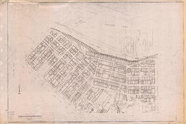
Sectional map of Vancouver showing streets, block and lot outlines, and building perimeters : Map 7 : Burrard Street to Main Street and Burrard Inlet to Georgia Street

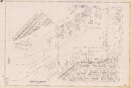
Sectional map of Vancouver showing streets, block and lot outlines, and building perimeters : Map 10 : Clark Drive to Nanaimo Street and Burrard Inlet to Frances Street/Ferndale Street
Sectional map of Vancouver showing streets, block and lot outlines, and building perimeters : Map 16 : Rupert Street to Boundary Road and Kitchener Street to 5th Avenue
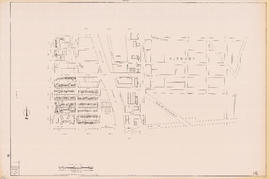
Sectional map of Vancouver showing streets, block and lot outlines, and building perimeters : Map 21 : False Creek waterfront and adjacent buildings from foot of Drake Street to Main Street
Sectional map of Vancouver showing streets, block and lot outlines, and building perimeters : Map 25 : Blanca Street to Jericho Beach Park and English Bay to 4th Avenue
Sectional map of Vancouver showing streets, block and lot outlines, and building perimeters : Map 28 : Camosun Street to Balaclava Street and 4th Avenue to 14th Avenue

Sectional map of Vancouver showing streets, block and lot outlines, and building perimeters : Map 29 : Balaclava Street to Maple Street and 3rd Avenue to 14th Avenue

Sectional map of Vancouver showing streets, block and lot outlines, and building perimeters : Map 30 : Maple Street to Oak Street and 3rd Avenue/6th Avenue to 14th Avenue

Sectional map of Vancouver showing streets, block and lot outlines, and building perimeters : Map 31 : Oak Street to Main Street and 6th Avenue/4th Avenue to 16th Avenue
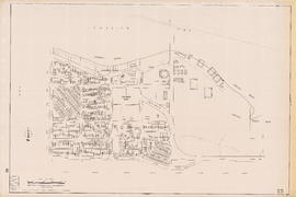
Sectional map of Vancouver showing streets, block and lot outlines, and building perimeters : Map 38 : Nanaimo Street to Rupert Street and Grandview Highway to 22nd Avenue

Sectional map of Vancouver showing streets, block and lot outlines, and building perimeters : Map 45 : Discovery Street/Camosun Street to Blenheim Street and 14th Avenue to King Edward Avenue

Sectional map of Vancouver showing streets, block and lot outlines, and building perimeters : Map 53 : Inverness Street to Nanaimo Street and 32nd Avenue to 41st Avenue
Results 1 to 50 of 268