
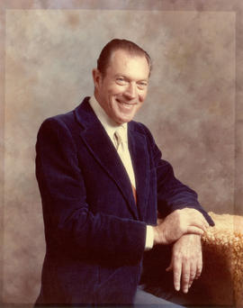
Kenneth Dobell, City Manager 1990-1998
- COV-S578---: PRS 578-114E7f7.6
- Item
- [ca. 1990-1998]
Part of City of Vancouver fonds
Kenneth Dobell, City Manager 1990-1998
Part of City of Vancouver fonds

Fritz Bowers, City Manager 1977-1990
Part of City of Vancouver fonds

L. E. Ryan, City Manager 1965-1977
Part of City of Vancouver fonds
Gerald Sutton Brown, Commissioner 1960-1973
Part of City of Vancouver fonds

J. C. Oliver, Commissioner 1956-1965
Part of City of Vancouver fonds

Frank Jones, Commissioner 1956-1958
Part of City of Vancouver fonds

Part of City of Vancouver fonds
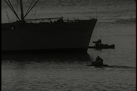
Item is a documentary film documenting the issue between the development of cityports and residential areas near the Vancouver shoreline. Film contains historical images of cityports and scenes of ports at Halifax and London, England for comparison to the situation in Vancouver.
Part of City of Vancouver fonds
Item is a documentary film documenting the transportation and population issues that impact access to downtown Vancouver. Film contains scenes of driving on the Granville Street Bridge, people attending a show, on a beach and walking around city streets at both daytime and evening.

The New Granville Bridge, reel 3
Part of City of Vancouver fonds
Item is a documentary film documenting the old Granville Street Bridge, its demolition, and the site of the new bridge. Film documents all stages of construction from 1950 to 1954 to the completion and opening ceremonies of the new bridge. Film also shows the north and south Granville Street approaches to the new bridge.

The New Granville Bridge, reel 2
Part of City of Vancouver fonds
Item is a documentary film documenting the old Granville Street Bridge, its demolition, and the site of the new bridge. Film documents all stages of construction from 1950 to 1954 to the completion and opening ceremonies of the new bridge. Film also shows the north and south Granville Street approaches to the bridge. Reel 2 of 3. Includes narrative captions.

The New Granville Bridge, reel 1
Part of City of Vancouver fonds
Item is a documentary film documenting the old Granville Street Bridge, its demolition, and the site of the new bridge. Film documents all stages of construction from 1950 to 1954 to the completion and opening ceremonies of the new bridge. Film also shows the north and south Granville approaches to the bridge. Reel 1 of 3. Includes narrative captions.
![[GranTree Furniture Rental fire, fisheries fire, and apartment building fire]](/uploads/r/null/4/1/417109/551ea832-89d2-46c6-a716-1b6d3732bee8-V00157_142.jpg)
[GranTree Furniture Rental fire, fisheries fire, and apartment building fire]
Part of City of Vancouver fonds
Item is an organizational record film documenting the GranTree Furniture Rental fire, the fire at Lion's Gate Fisheries, Tullock Western fisheries, and Central Native Fisherman's Co-operative, and an apartment building fire in the West End. The GranTree Furniture Rental segment shows surrounding storefronts of Hertz Rental Cars and Denny's Restaurant (probably downtown), as well as the interior of the furniture store with firefighters moving sofas, rugs, etc. The second segment shows firefighters fighting the warehouse fires at the Central Native Fisherman's Co-operative, Lion's Gate Fisheries, and Tullock Western Fisheries, including a shot of dead fish strewn about. The third segment shows firefighters fighting a fire at a West End apartment building, coroners removing the bodies, and an interview with a resident, Frank Toshack.
![[Car crash on Clark Drive and apartment building fire]](/uploads/r/null/4/1/417098/780c8f06-825a-47a2-9ebe-17b5b1e2d3cc-V00153_142.jpg)
[Car crash on Clark Drive and apartment building fire]
Part of City of Vancouver fonds
Item is an organizational record film documenting firefighters tending to a car crash on Clark Drive and an apartment building fire. The first segment shows a totalled car, with firefighters searching for victims in the burnt car and coroners coming to take the bodies away. Also includes an interview with the first police officer on the scene, Robert Clooney. The second segment shows firefighters fighting an apartment building fire by aerial ladder and performing first aid for victims, including one injured firefigher. A police boat is stationed in the water in front of the building.

Part of City of Vancouver fonds
Item is an organizational record film documenting a fire hose demonstration with Mayor Tom Campbell attending and the Vancouver Fire Department fighting four Vancouver fires. The fire hose demonstration takes place in front of Mine Mill Marine Machinery near the Cambie swingspan bridge. Also shows Johnston Terminals, a tug boat, the new Granville Street Bridge, the Fire Chief being interviewed, and men in scuba suits kicking boards that have fire hoses spouting water. Film also shows apartment building fire, fire at Hudson Plating Co. Ltd. at W 5th and Alberta St., fire at a Danish bakery at W 4th and Stephens, and a fire at a rail shipping and loading station on the docks, which shows Fireboat No. 2 in action.
![[Apartment building fire]](/uploads/r/null/4/1/417077/2b11ade5-ab14-46b6-96b8-80699cdb780a-V00151_142.jpg)
Part of City of Vancouver fonds
Item is an organizational record film documenting an apartment building fire (address 257 street unknown) that shows firefighters wearing oxygen tanks fighting the fire inside the building as well as on the roof using an aerial ladder.

Part of City of Vancouver fonds
Item is a organizational record film documenting fire safety procedures and a fire safety display for Fire Prevention Week. Shows firefighters doing fire inspections, including one of the Shaughnessy Hospital, and examining fire extinguishers. Also shows the fire safety display with fire apparatus and hazards in the home, as well as an interview with the Fire Chief.

Leo's Steak House fire and car crash
Part of City of Vancouver fonds
Item is an organizational record film documenting the Leo's Steak House fire. Film shows firefighters breaking into the building to put out what appears to be an electrical fire and firefighters on an aerial ladder to fight the fire on the roof. Also shows policemen at the scene of a car crash. Warning: graphic images.

Part of City of Vancouver fonds
Item is an organizational record film documenting the Vancouver Fire Department's rescue work after the fire at the Stratford Hotel, located at Gore Avenue and Keefer Street. Film shows firefighters escorting victims from the building and performing first aid, ambulances and firetrucks, and spectators watching the scene.
Part of City of Vancouver fonds
Item is a documentary film documenting the history of the Cambie Street Bridge including the demolition of its predecessor, the Connaught Bridge. Film includes archival film and photographs as well as contemporary footage.

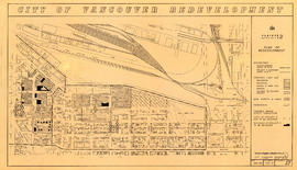
Project 2, area a-2 : proposed property acquisitions project 2
Part of City of Vancouver fonds
Item is a map showing boundaries of project in area a, property to be acquired, proposed street widening and city owned property included. Annotations show boundaries of project areas, property too be acquired, proposed street widening and properties already owned by the City. Map has been noted as Preliminary.
Project 2, area "h" and part of "b" : plan of redevelopment
Part of City of Vancouver fonds
Item is a map showing the boundaries of redevelopment areas "b" and "h", the boundaries of project 2 clearance areas 8 and 9, proposed land use, new streets and lanes, easements, sites in project 2 not to be acquired and buildings in project 2 to be retained in the area from Terminal Avenue in the north to Broadway in the south and from Clark Drive in the east to Main Street in the west.

Project 2 : generalized plan of redevelopment
Part of City of Vancouver fonds
Item is a map showing the boundaries of redevelopment (both "comprehensive" and "limited"), the boundaries of clearance areas for project 1, the boundaries of clearance areas for project 2, the proposed street system and the proposed land use for the city of Vancouver from Burrard Inlet in the north to 16th Avenue in the south and from Nanaimo Street in the east to Arbutus Street in the west.

Project 2: identification plan
Part of City of Vancouver fonds
Item is a map showing city owned property, adjacent lots in same ownership, non-adjacent lots in same ownership, property to be acquired, streets and lanes to be acquired, the boundaries of project 2 clearance, the boundaries of project 1 clearance and the realignment of Raymur Avenue in the area from Railway Street in the north to Atlantic Street in the south and from Clark Drive in the east to Main Steet in the west.

Project 2, area a-2 : condition of buildings
Part of City of Vancouver fonds
Item is a map showing condition of buildings (ranging from very good to very poor) and sites without buildings in use for storage or parking in the area from Railway Street in the north to Atlantic Street in the south and from Clark Drive in the east to Main Street in the west.

Project 2, area "h" and part of "b" : condition of buildings
Part of City of Vancouver fonds
Item is a map showing the conditions of buildings (ranging from very good to very poor) in area "a" and part of area "b" in project 2. The map has been annotated to highlite part of the boundary around sub-area 9, as well as the southern portion of the sub-area. The significance of these annotations is not known.

Project 2, area "h" and part of "b" : plan of redevelopment
Part of City of Vancouver fonds
Item is a map showing boundaries of redevelopment areas "b" and "h", boundaries of project 2 clearance for areas 8 and 9, in project 2, proposed land use, new streets and lanes, sites in project 2 not to be acquired and buildings in project 2 to be retained.

Project 2, area "h" and part of "b" : existing gas, electricity and telephone
Part of City of Vancouver fonds
Item is a map showing the gas lines, the electricity lines, the telephone lines, the boundaries of redevelopment for areas "b" and "h" and the boundaries of project clearance for areas 8 and 9 in redevelopment project 2.

Project 2, area "h" and part of "b" : existing utilities, water and sewer
Part of City of Vancouver fonds
Item is a map showing the water lines, the sewer lines, the direction of sewer flow, the boundaries of redevelopment for areas "b" and "h" and the boundaries of project clearance for areas 8 and 9 in redevelopment project 2.

Project 2, area "h" and part of "b" : pavements, curbs and sidewalks
Part of City of Vancouver fonds
Item is a map showing the types of pavement, the curbs and gutters, the sidewalks, the boundaries of redevelopment for areas "b" and "h" and the boundaries of project clearance for areas 8 and 9 for redevelopment project 2.

Project 2, area "h" and part of "b" : condition of buildings
Part of City of Vancouver fonds
Item is a map showing the condition of buildings (ranging from very good to very poor), the boundaries of redevelopment for areas "b" and "h" and the boundaries of project clearance for areas 8 and 9 for redevelopment proct 2.

Project 2, part of area "a" : identification plan
Part of City of Vancouver fonds
Item is a map showing property status for properties in project areas 1 and 2. The map shows city owned property, adjacent lots in same ownership, non-adjacent lots in same ownership, and property to be acquired.

Project 2, part of area "a" : plan of redevelopment
Part of City of Vancouver fonds
Item is a map showing the boundaries of clearance areas for projects 1 and 2, the proposed land use (residential, commercial, industrial or school and park sites), the proposed ultimate street system, the new streets and lanes in projects 1 and 2, the easements in projects 1 and 2, the sites in project 2 not to be acquired and the buildings in projects 1 and 2 to be retained.

Project 2, part of area "a" : existing gas, electricity and telephone
Part of City of Vancouver fonds
Item is a map showing the gas lines, overhead and underground electricity lines, overhead and underground telephone lines, and fire alarms underground in project 2 area "a".

Project 2, part of area "a" : existing utilities, water and sewer
Part of City of Vancouver fonds
Item is a map showing the configuration of water and sewer services in project 2 area "a". The map depicts the water pipes (10" and over), the sewers (15" and over), and the direction of sewer flow.

Project 2, part of area "a" : pavements, curbs and sidewalks
Part of City of Vancouver fonds
Item is a map showing the types of pavements, curbs, gutters and sidewalks in project 2 area "a'".

Project 2, part of area "a" : condition of buildings
Part of City of Vancouver fonds
Item is a map showing the condition of buildings (ranging from very good to very poor) within the boundaries of project 2, area "a". The map also shows the boundaries of project 2 clearance, the boundaries of project 1 clearance and the realignment of Raymur Avenue.

Project 2, part of area "a" : aerial photograph
Part of City of Vancouver fonds
Item is a map showing the boundaries of clearance areas for project 1 (sub areas 1, 2 & 3) and project 2 (sub areas 5, 6 & 7). These areas have been outlined in yellow.

Project 2 : generalized plan of redevelopment
Part of City of Vancouver fonds
Item is the index map showing the boundaries of the various sub-areas of redevelopment project no. 2. The map shows the boundaries of clearance and redevelopment areas, the proposed street system and the proposed land use for the area from Burrard Inlet in the north to 16th Avenue in the south and from Nanaimo Street in the east to Arbutus Street in the west.

Project 2 area "h" and part of "b" : identification plan
Part of City of Vancouver fonds
Item is a map created to show the boundaries of redevelopment areas "b" and "h" in Project 2 and Project 2 clearance areas 8 & 9. The map also shows City-owned property, Adjacent lots in same ownership, as well as property, streets and lanes be acquired for the project. The portion of the City depicted in the map is the area between Main Street and Clark Drive and between Evans Avenue and 10th Avenue (D.L.200, D.L. 264A, D.L. 301, and D.L. 2037).

Part of City of Vancouver fonds
Item is a map prepared as part of the Harbour Headline project of the False Creek Development Study. Map shows existing, interim and ultimate harbour headlines, existing water areas, ownership boundaries, other property lines and lease boundaries in and around False Creek.

Capilano and Seymour water sheds
Part of City of Vancouver fonds
Item is a map showing Capilano and Seymour water sheds, reservoirs, pipelines, lot numbers and major roads in the area from Howe Sound to Port Moody and Britannia to Delta. The item includes information about the drainage area, annual precipitation and annual runoff associated with the Capilano and Seymour water sheds.
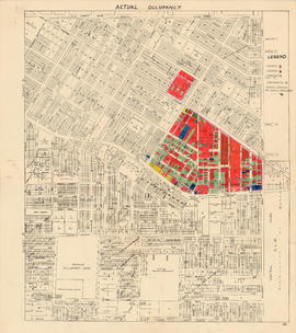
Actual occupancy : area bounded by Joyce Street, Boundary Road, Wellington Avenue and Kingsway
Part of City of Vancouver fonds

Water services : area bounded by Joyce Street, Boundary Road, Wellington Avenue and Kingsway
Part of City of Vancouver fonds

Sewage : area bounded by Joyce Street, Boundary Road, Wellington Avenue and Kingsway
Part of City of Vancouver fonds

Plan to accompany report on proposed bridge at Marpole across North Arm of Fraser River
Part of City of Vancouver fonds
Item is a map showing five possible locations for a bridge across the North Arm of the Fraser River from the city of Vancouver to either Sea Island or Lulu Island.

City of Vancouver : households and population by enumeration areas : 1961 census
Part of City of Vancouver fonds
Item is a map annotated to show census tract numbers and boundaries, enumeration area boundaries, and households and pooulation within enumeration areas. Other numbers are hand-written on some of the areas, but the meaning of these numbers is unknown. Base map shows streets, parks, and golf courses.

Sectional map City of Vancouver, B.C.
Part of City of Vancouver fonds
Item is a sectional plan which shows the area bounded by Victoria Drive to Twenty-second Avenue to Knight Street to Thirty-third Avenue. The map is an unapproved preliminary copy with lot and other data added in pencil.
Vancouver (B.C.). Office of the City Engineer
![Profile of pipe-line : Capilano intake to Little Mt. [Mountain] reservoir](/uploads/r/null/f/d/e/fde7fb6226629fad04bbf9be7365df117c8a21327882aba29740dae663d9c8fb/a5da6578-eab7-4510-9aa2-cc05f6ce537d-MAP866_142.jpg)
Profile of pipe-line : Capilano intake to Little Mt. [Mountain] reservoir
Part of City of Vancouver fonds

Part of City of Vancouver fonds
Item is a land survey plan showing locations of survey posts, boundaries between reserve and non-reserve lands, streets, rights of way, and high water marks.

Key map showing proposed areas for partial and comprehensive redevelopment
Part of City of Vancouver fonds
Item is a map showing the boundaries of the redevelopment study area, comprehensive redevelopment areas, limited redevelopment areas and the East End study area. The boundary of the study area lies roughly between Burrard Inlet in the north and 33rd Avenue in the south and between Nanaimo Street in the east and Carnarvon Street in the west.