Canadian Pacific Railway exploration maps
Add to clipboard
Canadian Pacific Railway exploration maps
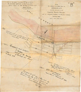
City of Vancouver, British Columbia [sectional map]
Add to clipboard
City of Vancouver, British Columbia [sectional map]
Vancouver Harbour [nautical charts]
Add to clipboard
Vancouver Harbour [nautical charts]
City of Vancouver, Vancouver, British Columbia : sectional maps
Add to clipboard
City of Vancouver, Vancouver, British Columbia : sectional maps
Insurance plan of Vancouver, British Columbia. Volume two
Add to clipboard
Insurance plan of Vancouver, British Columbia. Volume two
Vancouver : neighborhoods
Add to clipboard
Vancouver : neighborhoods
Goad's Atlas of Vancouver Vol. 1
Add to clipboard
Goad's Atlas of Vancouver Vol. 1
Vancouver B.C. waterfront map
Add to clipboard
Vancouver B.C. waterfront map
British Properties maps
Add to clipboard
British Properties maps
Goad's Atlas of the City of New Westminster, B.C.
Add to clipboard
Goad's Atlas of the City of New Westminster, B.C.
Goad's Atlas of the City of Vancouver British Columbia and Surrounding Municipalities in Four Volumes. Volume One
Add to clipboard
Goad's Atlas of the City of Vancouver British Columbia and Surrounding Municipalities in Four Volumes. Volume One
City of Vancouver, Vancouver, British Columbia : sectional maps
Add to clipboard
City of Vancouver, Vancouver, British Columbia : sectional maps
City of Vancouver, Vancouver, British Columbia : sectional maps (printed 1970)
Add to clipboard
City of Vancouver, Vancouver, British Columbia : sectional maps (printed 1970)
Drawings of first Vancouver opera house (761 Granville Street)
Add to clipboard
Drawings of first Vancouver opera house (761 Granville Street)
Vancouver Harbour [sectional map]
Add to clipboard
Vancouver Harbour [sectional map]
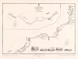
Fraser River investigation
Add to clipboard
Fraser River investigation
City of Vancouver Archives technical and cartographic drawing collection
Add to clipboard
City of Vancouver Archives technical and cartographic drawing collection
Add to clipboard
Plan of a portion of the water front of Vancouver city
Street map of Vancouver, Burnaby, New Westminster, British Columbia
Add to clipboard
Street map of Vancouver, Burnaby, New Westminster, British Columbia
Victoria and Vancouver street and vicinity maps
Add to clipboard
Victoria and Vancouver street and vicinity maps
B.C. Electric guide to Greater Vancouver
Add to clipboard
B.C. Electric guide to Greater Vancouver
Add to clipboard
Plan of part of West Vancouver District
Add to clipboard
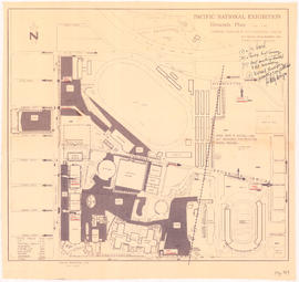
Pacific National Exhibition grounds plan
Add to clipboard
Plan 3
Add to clipboard
Town-site of Hastings
Add to clipboard
Pacific National Exhibition grounds plan : parking available for proposed arena
Add to clipboard
General development plan, Exhibition Park, Vancouver, B.C.
Add to clipboard
Vancouver sewers
Add to clipboard
A preliminary proposal for development of Jericho Park
Unemployment relief works under Department of National Defence, Canada 31st Dec. 1934
Add to clipboard
Unemployment relief works under Department of National Defence, Canada 31st Dec. 1934
Add to clipboard
Unemployment relief works under Department of National Defence, Canada : British Columbia and Alberta
Add to clipboard
Vancouver Harbour, British Columbia
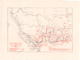
Western Canada
Add to clipboard
Western Canada
Burnaby zoning
Add to clipboard
Burnaby zoning
Shell map of Vancouver, B.C. and Victoria, B.C.
Add to clipboard
Shell map of Vancouver, B.C. and Victoria, B.C.
Circulation map of Greater Vancouver by telephone exchange areas
Add to clipboard
Circulation map of Greater Vancouver by telephone exchange areas
[False Creek basin]
Add to clipboard
[False Creek basin]
Scarborough's New Map of British Columbia
Add to clipboard
Scarborough's New Map of British Columbia
Add to clipboard
Sketch of the upper part of the Fraser River from Langley to Yale
Add to clipboard
Plan of provincial government property being a sub-division of a portion of expired timber lease situated in North Vancouver, New Westminster district, B.C., to be sold by public auction
Add to clipboard
Plan of sub-division of lot 2027, group 1, New Westminster District, B.C., to be sold by public auction at Vancouver, B.C.
Add to clipboard
Plan of provincial government property being a portion of townsite of Vancouver and sub-division of lot 540, group 1, New Westminster District, B.C., to be sold by public auction at Vancouver, B.C.
Add to clipboard
Plan of part of sub-division of district lot 540, South Vancouver, provincial government property
Add to clipboard
Plan of the municipality of South Vancouver
Add to clipboard
Pictorial map of Greater Vancouver showing dates of settlement in specific areas and opening dates of regional landmarks
Add to clipboard
Vancouver sheet, British Columbia
Commercial map of Greater Vancouver and district [planning]
Add to clipboard
Commercial map of Greater Vancouver and district [planning]
Add to clipboard
Plan of Greater Vancouver, British Columbia
Commercial Map of Greater Vancouver and District [BC]
Add to clipboard
Commercial Map of Greater Vancouver and District [BC]
Add to clipboard
Map and guide of Greater Vancouver