- AM1594-: MAP 851
- Item
- 19--
Part of City of Vancouver Archives technical and cartographic drawing collection
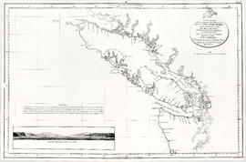
Map shows Juan de Fuca Strait, the San Juan Islands and the southern portion of Vancouver Island.
89 results with digital objects Show results with digital objects
Part of City of Vancouver Archives technical and cartographic drawing collection
Map shows Juan de Fuca Strait, the San Juan Islands and the southern portion of Vancouver Island.

British Garrison, San Juan Island
Part of Major Matthews collection

Part of Major Matthews collection

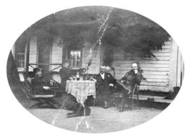
Officers' Quarters, San Juan Island
Part of Major Matthews collection
Part of Major Matthews collection
Photograph shows officers relaxing with libations and a dog
![San Juan and H.M.S. "Boxer" [and] Pritchard's Sloop](/uploads/r/null/4/0/40ea9d4528a5c4b3ec98885eff16456bc19f0ae6554095f5ff1b3ac7f407a63f/a498747b-10ca-40c7-b9b8-07567f9976ae-A26902_142.jpg)
San Juan and H.M.S. "Boxer" [and] Pritchard's Sloop
Part of Major Matthews collection
![[View of the British Garrison at] San Juan](/uploads/r/null/0/f/0f1437452ca2a7b285ae1da89a8614c4b42987d1eaad6b306291788223454918/e5280f9b-8b87-4dbc-9023-c68bd8014efd-A26906_142.jpg)
[View of the British Garrison at] San Juan
Part of Major Matthews collection
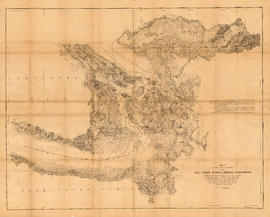
Map showing the line of boundary between the United States and British possessions
Part of City of Vancouver Archives technical and cartographic drawing collection
Item is a map showing four proposed boundaries between the United States and British possessions in the Salish Sea region. The explanations of the lines read in part: "[1] Boundary line contemplated by the Treaty as shown by contemporaneous evidence; [2] Boundary line as claimed by the British Commissioner; [3] Boundary line proposed by the British Commissioner as a compromise ( . . . ); [4] Boundary line in accordance with the strict letter of the Treaty ( . . . ). Item also shows soundings, and the "track of steamers plying between Victoria and Fraser river since discovery of gold."
![[Cross sections of ocean floor between Vancouver Island and mainland of British Columbia]](/uploads/r/null/c/a/6/ca687b43e46696a0c1d9223ef1e80ebe50bba0ea48092c458b525fc90f7b517c/7d458083-64ae-4682-be03-8fd1211e38c9-MAP8b_142.jpg)
[Cross sections of ocean floor between Vancouver Island and mainland of British Columbia]
Part of City of Vancouver Archives technical and cartographic drawing collection
Item shows ocean floor cross sections at 49 degrees latitude, 48 degrees 45', 48 degrees 35', and 48 degrees 25'. Islands and other geographical features are indicated.
Part of City of Vancouver Archives technical and cartographic drawing collection
Map shows the discoveries made in 1792 on the north-west coast of North American by examining Juan de Fuca Strait and the corresponding navigable channels, prepared for Dionisio Galiano and Captain Valdes, naval captains of the Royal (Spanish) Fleet in the year 1795.


Photograph shows the "Pacific Sunrise"

Photograph shows the "Sunrise Maid"

Photograph shows the "Nordic Queen"

Photograph shows the "Chamiss"
Photograph shows the "Walter H"

Photograph shows the "Chamiss Bay"


Photograph shows the "Seamark II" and the "Cape Calvert"
Photograph shows the "Cape Caution"

Photograph shows the "Northisle"

Photograph shows the "Cape Midge"

Photograph shows the "Sunrise Maid"


Photograph shows the "Splendour"


Photograph shows the "Cape Calvert"

Photograph shows the "Mays"
Photograph shows the "Tartoo"


Photograph shows the "Canfisco"

Photograph shows the "Irene W"

Photograph shows the "Jessie Island No. 2"


Photograph shows the "Qualicum L"

Photograph shows the "Skidegate"

Photograph shows the "Bligh Island"


Photograph shows the "B.C. Pride"
Stamp on verso of print "Publishers Please Note / If published this photograph / must carry credit / 'Steffens-Colmer Photo' "
Stamp on verso of print "Note Our / New Address- / Steffens-Colmer Ltd / 298 Main Street "

Photograph shows the "Good Hope 2" and the "Splendour" in the background

Photograph shows the "Early Field"

Photograph shows the "Splendour" and the crew: Mike Haveruk, Spiro Dedijer, Glenn Martinolich, Aldwin Martinolich, Bob Popovanc and Matt Martinolich

Photograph shows the "Bligh Island"

Photograph shows the "Western Warrior"