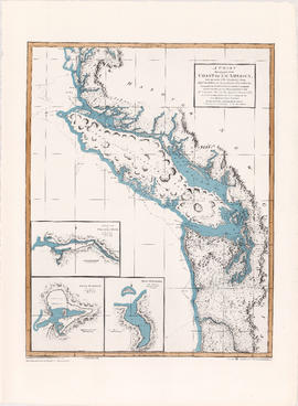
Carta esferica de los reconocimientos hechos en la costa No. de America des de la parte en que empiezan a angoftar de Juan de Fuca hafta la salidade las Goletas Sutil y Mexicana
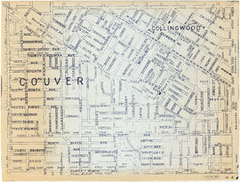
Vancouver downtown property map
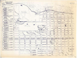
False Creek Basin
False Creek, Vancouver, B.C.
Vancouver : as seen from space : vue de l'espace
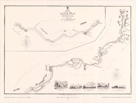
Sketch of the upper part of the Fraser River from Langley to Yale
North-east False Creek Map
Map of City of Vancouver [City services locations]
City of Vancouver, British Columbia : co-ordinate street index map 12
City of Vancouver [park sites June/80]
City of Vancouver
City of Vancouver
Chinatown existing
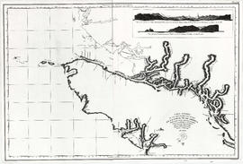
A chart shewing part of the coast of N.W. America
A chart shewing part of the coast of N.W. America
Chinatown existing
City of Vancouver
Vancouver, B.C. 1890 : built-on area
Vancouver : urban growth, 1865-1970
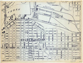
Sheet 1 : Boundary Road to Burrard Inlet to Templeton Drive to Charles Street
Sheet 4 : Boundary Road to 24th Avenue to Victoria Drive to Forty-ninth Avenue
Sheet 6 : Penticton Street to Burrard Inlet to Princess Avenue to William Street
Sheet 12 : Prince Albert Street to East Seventeenth Avenue to Laurel Street to East Twenty-ninth Avenue
Sheet 14 : Prince Albert Street to Forty-ninth Avenue to Laurel Street to Kent Avenue
Sheet 17 : Oak Street to Connaught Street to Elm Street to West 50th Avenue
Sheet 23 : Vine Street to Forty-first Avenue to Salish Drive to Fraser River
Sheet 28 : Main Street to Twenty-ninth Avenue to Granville Street to Fiftieth Avenue
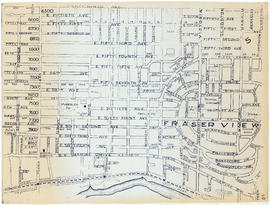
Sheet 5 : Boundary Road to Forty-ninth Avenue to Victoria Drive to Kent Avenue
Sheet 13 : Ross Street to Twenty-ninth Avenue to Heather Street to Forty-ninth Avenue
Sheet 16 : Cambie Street to West Fifteenth Avenue to Arbutus Street to Thirty-fifth Avenue
Sheet 18 : Laurel Street to West Forty-ninth Avenue to Marine Crescent to Seventieth Avenue
Sheet 20 : Granville Street to English Bay to Trutch Street to West Sixteenth Avenue
Sheet 22 : Vine Street to Thirty-first Avenue to Camosun Street to Fifty-first Avenue
Sheet 25 : Balaclava Street to Fifteenth Avenue to Blanca Street to Thirty-fifth Avenue
Railroad map of Greater Vancouver, British Columbia
Sheet 3: Boundary Road to East Broadway to Lakewood Street to Galt Street
Sheet 7 : Penticton Street to East Georgia Street to Carolina Street to Twelfth Avenue
Sheet 8 : Nanaimo Street to Twelfth Avenue to St. George Street to Thirty-third Avenue
Sheet 9 : St. Margaret Street to Twenty-ninth Avenue to St. George St. to East Forty-ninth Avenue
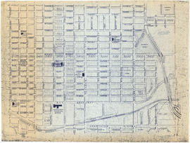
Sheet 11 : Clark Drive to Atlantic Street to Cambie Stree to East Sixteenth Avenue
Sheet 19 : Cambie Street to Fifty-seventh Avenue to Arbutus Street to Fraser River
Sheet 21 : Cypress Street to West Fifteenth Avenue to Highbury Street to Thirty-fifthe Avenue
Sheet 26 : Highbury Street to English Bay to Tasmania Boulevard to Seventeenth Avenue
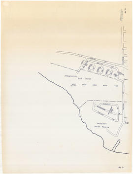
Sheet 31 : Camosun Street to Shaughnessy golf course to Fraser River to Salish Drive
Sheet 2 : Boundary Road to Venables Street to Lakewood Street to East Fourteenth Avenue
Sheet 10 : Clarendon Street to Forty-ninth Avenue to St. George Street to Fraser River
Sheet 15 : Columbia Street to Drake Street to Cypress Street to West Eighteenth Avenue
Sheet 24 : Balaclava Street to English Bay to Tolmie Street to Nineteenth Avenue
Redevelopment plan for Jericho Department of National Defence lands


![Map of City of Vancouver [City services locations]](/uploads/r/null/5/7/7/577519f13333b5141f19d58696ae109b192fab0007ff302e15453cab74e21dd3/3a32f9e1-f624-41f7-980d-3b5df4397fb6-MAP225_142.jpg)

![City of Vancouver [park sites June/80]](/uploads/r/null/9/4/9484add7c4684ea3838e4d00ee8add3ecf85d78d5aa8fe2780cae273e59556a5/bd2464d8-2aa9-4501-aba6-8b3f7d130a42-MAP1032_142.jpg)