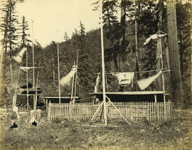
Indian cemetery near Boston Bar
- AM1376-: CVA 3-26
- Item
- [between 1866 and 1870]
156 results with digital objects Show results with digital objects
Indian cemetery near Boston Bar
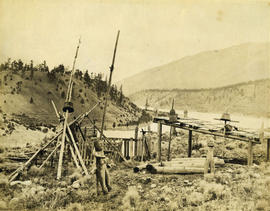
Indian cemetery near Lytton on the Thompson River below Spences Bridge
Photograph shows a grave with funeral artifacts

Indian Cemetery near Lytton 57 miles above Yale
Photograph shows a grave with funereal artifacts
![Mtn. [Mountain] View Cemetery, Chinese portion](/uploads/r/null/7/c/7c56c0b71890c8af4476e74efd666e0715018aa723d488d20ccb356f16e6fb56/2e50d0da-96f4-4f70-8026-c0abcf27656f-A70858_142.jpg)
Mtn. [Mountain] View Cemetery, Chinese portion
Part of H.A. Price collection
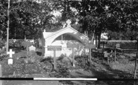
![[War memorial at] St. John's Cemetery](/uploads/r/null/d/3/d3e110baa6b8a0cb658ea5d2314815024bc4c739b0d21c8085d9a0a30cc75cb3/b3e2a600-feb5-4035-851d-99f167691be8-A04112_142.jpg)
[War memorial at] St. John's Cemetery
Part of Major Matthews collection
J.S. Matthews' notes with print or negative in Archives.
In memoriam of our fallen soldiers. St. John's Cemetery
Part of Major Matthews collection
J.S. Matthews' notes with print or negative in Archives.
![Indian cemetery near North Bend [B.C.]](/uploads/r/null/e/5/e581330c09ea70e1dd2ef814352a31523b696f2189336b34b867423549ec5d71/bd23e177-4506-4988-9532-3bb392884c14-A04100_142.jpg)
Indian cemetery near North Bend [B.C.]
Part of Major Matthews collection
J.S. Matthews' notes with print or negative in Archives.
![[Elks rest monument in] a Detroit cemetery](/uploads/r/null/5/9/591f6deb70cc63f780321089794543271aee91157eb2ea5d1603d5a0ecaead9f/8ba8532c-85ee-43c0-93ae-17b72d782270-A26606_142.jpg)
[Elks rest monument in] a Detroit cemetery
Part of Major Matthews collection
![[Graveyard on Indian Reserve, North Vancouver]](/uploads/r/null/b/0/b081b0a4ffac356d69740ecfcd16ce2bbf2fc1b3bd008ce958b21a26502381b9/50a909bb-ec01-4286-9be8-ed120d090838-A08064_142.jpg)
[Graveyard on Indian Reserve, North Vancouver]
Part of Major Matthews collection
Photograph shows grave stones and monuments in foreground and forest and mountain peaks in the distance.
![[Chapel in Detroit cemetery]](/uploads/r/null/9/a/9a1bee42ba8d99e1497622c150c1efeaa4e14200f0be09129f46d28d772a89fe/25da4155-e5fa-4a12-ade8-67b30bb6e58a-A26608_142.jpg)
Part of Major Matthews collection
![[Church cemetery]](/uploads/r/null/4/b/d/4bdd342cc9df139f37f4b676acd681fa6b837f9066c5775f276212f2c759994f/500626d3-2ffc-46e8-b76a-7acc8d75f681-AM1052P-1838_142.jpg)
Mountain View Cemetery regulations
![[View of Mountain View Cemetery looking north from 41st Avenue and showing the Jones addition]](/uploads/r/null/d/7/d70d6a4c26889d22581e1a7e80527e61b112a742324c2c7fe067d98088c178fb/eed968e8-0080-49bc-96f8-8be88b0286b1-A19305_142.jpg)
[View of Mountain View Cemetery looking north from 41st Avenue and showing the Jones addition]
Part of Major Matthews collection
Photograph shows the crematorium.
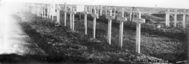
![Cemetery [at] Villers-au-Bois](/uploads/r/null/6/3/63923d81aef3535ca39b302f10ed21bf7b3d10b445a23c0feade6e6058b4164c/41dc6d9b-9708-4f9d-a545-1a2c3d5cb262-A26202_142.jpg)
Part of Major Matthews collection
Photograph shows the wodden crosses and graves of members of the 54th Battalion Canadian Infantry
Part of Major Matthews collection
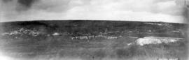
Photograph shows Vimy Ridge
Part of Major Matthews collection
Photograph shows wooden crosses and graves of members the 54th Battalion Canadian Infantry
![[Ruins of an unidentified church]](/uploads/r/null/f/4/1/f41d2a46b7419adc0755166850d45ed388eac9b2d99017239f85f1f38cfdfb30/384812df-a0bc-4765-bb87-adbe5a5e4209-CVA260-1119_142.jpg)
[Ruins of an unidentified church]
Part of James Crookall fonds

Grave of Pauline Johnson, Stanley Park, Vancouver, Canada
![[Ocean View Burial Park entrance]](/uploads/r/null/c/8/c83c0aa20f44162abbfd24b9baedd85f15de20618e8a369e1dc9b11bd7a3cce1/d9b2365b-7e34-4b84-bb1d-5161e92718ab-A17765_142.jpg)
[Ocean View Burial Park entrance]
Part of Stuart Thomson fonds
![[View of graveyard where Captain Vancouver is buried]](/uploads/r/null/f/e/fecc9f7894fefd3ca091e8d6739ee7daf2fd0b6ff09436114c33873876ac45b6/9e7b4ff4-ec36-4acd-b4f2-99056ece7932-A10315_142.jpg)
[View of graveyard where Captain Vancouver is buried]
Part of Major Matthews collection
![[Captain George Vancouver's grave]](/uploads/r/null/b/8/b8f71188ba2acdca47e0d863a56829aad41787772a1576aff7056e541c946539/b7db2975-5739-465b-8f72-a2aaf3fbeee5-A10317_142.jpg)
[Captain George Vancouver's grave]
Part of Major Matthews collection
![[Ocean Park cemetery]](/uploads/r/null/e/3/e3ba8d3e3879664c3d52d8ec59d4eac0211342cefdbd3e697a18ba881d72b763/70324297-8702-4307-99ba-886429296642-A17763_142.jpg)
Part of Stuart Thomson fonds
![[Ocean View Burial Park entrance]](/uploads/r/null/c/d/cd52b880ac234660dd7418fa25320c7a928ba2909ffbd4ba9e73de6ed8ee9d54/4b692a91-376c-4e79-85cb-2a28820e525c-A17846_142.jpg)
[Ocean View Burial Park entrance]
Part of Stuart Thomson fonds
![[Captain George Vancouver's grave]](/uploads/r/null/3/a/3abd23333da5ce869450e01ec63aa4f3f25e5f2ae08a4f636f67da5fdc43bf0b/aa67e332-6660-4dfe-9651-b5c83d908027-A10318_142.jpg)
[Captain George Vancouver's grave]
Part of Major Matthews collection

Mausoleum for Frances C. McConnell at Ocean View Burial Park
Part of Stuart Thomson fonds
![Mountain View Cemetery - Masonic and family plot [at the burial of Hugh Boscawen Matthews]](/uploads/r/null/e/a/eac9835ddfebc1cdb2da12339141d8b1ac4fb252d09ee7b95ab36ec589dc2286/0ac3f2f7-5f89-442d-a7d0-1062c6d52b71-A71145_142.jpg)
Mountain View Cemetery - Masonic and family plot [at the burial of Hugh Boscawen Matthews]
Part of Major Matthews collection
Professionally taken photograph shows the Matthews family plot at Mountain View Cemetery and the burial of Hugh Matthews, the youngest son of Major Matthews, who died in an elevator accident in Vancouver, November 5, 1922.

Christchurch and war memorial, Prestatyn
Part of Major Matthews collection
Professionally taken ground level view of Christchurch and war memorial in Prestatyn, Flintshire, Wales where Herbert Lewis Matthews was buried.

Headstone of Neil Murdoch Adam and Jeanie Hay Adam
Part of Stuart Thomson fonds

Sheet 3 : Cambie Street to St. George Street and Twenty-seventh Avenue to Thirty-eighth Avenue
Part of City of Vancouver fonds
Item is a section showing the area from Cambie Street to St. George Street and Twenty-seventh Avenue to Thirty-eighth Avenue. Map shows streets, roads, blocks, lots and legal descriptions and the locations of parks, schools, reservoirs and Mountainview Cemetery. Map is hand coloured to show tax sale property for sale, property with no water, street widening and drainage, replotting, reserved land for schools, reserved land for parks, sundry land, capital assets not including schools and parks, schools, and parks, as applicable.
Vancouver (B.C.). Office of the City Engineer

Sheet S.V. 2 : Cambie Street to St. George Street and Twenty-eighth Avenue to Thirty-eighth Avenue
Part of City of Vancouver Archives technical and cartographic drawing collection
Item is a section showing the area from Cambie Street to St. George Street and Twenty-eighth Avenue to Thirty-eighth Avenue. Map shows streets, roads, blocks, lots and legal descriptions and the locations of parks, schools, reservoirs and Mountainview Cemetery. Annotations in pencil.
Vancouver (B.C.). Office of the City Engineer
![Ocean View Burial Park [Mr. Arnold, taken for Can Financiers Trust Co.]](/uploads/r/null/d/1/a/d1a04c67f496bd1a9e99791caa26ccd25ce24684267bc015b2ed88773d377849/04482c20-b662-4466-bdfb-d9e932279d16-CVA99-5269_142.jpg)
Ocean View Burial Park [Mr. Arnold, taken for Can Financiers Trust Co.]
Part of Stuart Thomson fonds

Part of Stuart Thomson fonds
![Ocean View Burial Park [Mr. Arnold, taken for Can Financiers Trust Co.]](/uploads/r/null/9/7/2/972547aa56fd4020656b24f0303ed424d91bf2061d97b3a53afcba3461691712/73c59b59-0c5d-4b4d-9560-38b867479361-CVA99-5508_142.jpg)
Ocean View Burial Park [Mr. Arnold, taken for Can Financiers Trust Co.]
Part of Stuart Thomson fonds
![Ocean View Burial Park [taken for Can Financiers Trust Co.]](/uploads/r/null/0/8/c/08c954067a61e10ebcea398dd330e00f693fc2e8c8f3a800f2c3cbefba2720b1/102f7806-b94f-415c-826d-d949c4ee7e11-CVA99-5509_142.jpg)
Ocean View Burial Park [taken for Can Financiers Trust Co.]
Part of Stuart Thomson fonds
![Ocean View Burial Park [Mr. Arnold, taken for Can Financiers Trust Co.]](/uploads/r/null/0/2/5/025268349ec62a92f79398a56e2d8cedf121949d2d79eac2c12e1aea1c92b196/4c16d8ec-cde7-42f6-a4f8-fbeac59b86a0-CVA99-5511_142.jpg)
Ocean View Burial Park [Mr. Arnold, taken for Can Financiers Trust Co.]
Part of Stuart Thomson fonds
![[Mrs. Chang Yat Leong beside a flower-covered grave]](/uploads/r/null/9/0/902b732f11314e865a909726ee76318690208a5d6e14365f256eb9ca34b2599f/2feff765-6d94-4254-bac0-3a8b5b10b7b9-A44630_142.jpg)
[Mrs. Chang Yat Leong beside a flower-covered grave]
Part of Sam Kee Company fonds

Banfield plot, Mt. Pleasant Cemetery, Toronto
Part of William Orson Banfield fonds

Sheet S.V. 3 : Cambie Street to Prince Edward Street and Thirty-ninth Avenue to Fiftieth Avenue
Part of City of Vancouver Archives technical and cartographic drawing collection
Item is a section showing the area from Cambie Street to Prince Edward Street and Thirty-ninth Avenue to Fiftieth Avenue. Map shows streets, roads, blocks, lots and legal descriptions, and the locations of parks, schools, golf courses and Mountainview Cemetery.
Vancouver (B.C.). Office of the City Engineer
![Ocean View Burial Park [Mr. Arnold, taken for Can Financiers Trust Co.]](/uploads/r/null/2/5/8/258b83ae65f516fa94c413a2c2e7ea356edab32d5921ca443e3a8e07c0bd4fbd/18012515-2e8c-4af4-acef-eee1184480d1-CVA99-5510_142.jpg)
Ocean View Burial Park [Mr. Arnold, taken for Can Financiers Trust Co.]
Part of Stuart Thomson fonds
![[Chang Yat Leong beside a flower-covered grave]](/uploads/r/null/7/c/7c8ac87c8bd15949eb98897cebf92a05a2bf006ff62e350ee890c9313555772d/d227c40a-7802-4998-bb96-8e4e94d4a0d9-A44629_142.jpg)
[Chang Yat Leong beside a flower-covered grave]
Part of Sam Kee Company fonds

Sheet 7 : Cambie Street to St. George Street and Thirty-seventh Avenue to Forty-eighth Avenue
Part of City of Vancouver fonds
Item is a section showing the area from Cambie Street to St. George Street and Thirty-seventh Avenue to Forty-eighth Avenue. Includes streets, roads, blocks, lots, legal descriptions, parks, cemeteries, and schools. Map is hand coloured to show tax sale property for sale, property with no water, street widening and drainage, replotting, reserved land for schools, reserved land for parks, sundry land, capital assets not including schools and parks, schools, and parks, as applicable.
Vancouver (B.C.). Office of the City Engineer

Sheet 8 : Prince Edward Street to Bruce Street and Thirty-fifth Avenue to Forty-seventh Avenue
Part of City of Vancouver fonds
Item is a section showing the area from Prince Edward Street to Bruce Street and Thirty-fifth Avenue to Forty-seventh Avenue. Includes streets, roads, blocks, lots, legal descriptions, and cemeteries, parks and schools. Map is hand coloured to show tax sale property for sale, property with no water, street widening and drainage, replotting, reserved land for schools, reserved land for parks, sundry land, capital assets not including schools and parks, schools, and parks, as applicable.
Vancouver (B.C.). Office of the City Engineer

Sheet 4 : Prince Edward Street to Bruce Street and King Edward Avenue to Thirty-sixth Avenue
Part of City of Vancouver fonds
Item is a section showing the area from Prince Edward Street to Bruce Street and King Edward Avenue to Thirty-sixth Avenue. Map shows streets, roads, blocks, lots and legal descriptions, and the locations of parks, schools and Mountainview Cemetery. Map is hand coloured to show tax sale property for sale, property with no water, street widening and drainage, replotting, reserved land for schools, reserved land for parks, sundry land, capital assets not including schools and parks, schools, and parks, as applicable.
Vancouver (B.C.). Office of the City Engineer
![Ocean View Burial Park [Mr. Arnold, taken for Can Financiers Trust Co.]](/uploads/r/null/7/b/8/7b8d0f0132e77842d9df62d855e303c0e477a3952fdc2a6d086bed48aba64f14/99617950-be93-4b0c-86f0-f8152b9f2973-CVA99-5269_142.jpg)
Ocean View Burial Park [Mr. Arnold, taken for Can Financiers Trust Co.]
Part of Stuart Thomson fonds

Sheet S.V. 6 : Prince Edward Street to Bruce Street and King Edward to Thirty-fifth Avenue
Part of City of Vancouver Archives technical and cartographic drawing collection
Item is a section showing the area from Prince Edward Street to Bruce Street and King Edward to Thirty-fifth Avenue. Includes streets, roads, blocks, lots, legal descriptions, parks, cemeteries, and schools. Annotations in ink and pencil.
Vancouver (B.C.). Office of the City Engineer

Sheet S.V. 7 : Prince Edward Street to Argyle Street and Thirty-fifth Avenue to Forty-seventh Avenue
Part of City of Vancouver Archives technical and cartographic drawing collection
Item is a section showing the area from Prince Edward Street to Argyle Street and Thirty-fifth Avenue to Forty-seventh Avenue. Includes streets, roads, blocks, lots, legal descriptions, parks, cemeteries, and schools.
Vancouver (B.C.). Office of the City Engineer
Part of Major Matthews collection
![[Yip Sang grave site at Mountain View Cemetery]](/uploads/r/null/c/5/c5d813de4b421e0ad6df1a0862937c75e4ad5642354b78d5d9983275fa894979/eec6808a-5aec-4a7f-ad69-b90646e1a1eb-A72938_142.jpg)
[Yip Sang grave site at Mountain View Cemetery]
Photograph shows a view of the grave site from a distance.
![[Yip Sang grave stone at Mountain View Cemetery]](/uploads/r/null/6/e/6e9b9874fda2df88c89477235d909b26f1dd61cd2248133db7f424f160a7221c/c0f71a3d-0445-4d59-882a-a3d5ab89660a-A72939_142.jpg)
[Yip Sang grave stone at Mountain View Cemetery]
![Soldiers memorial service, Last Post Association [people placing flowers in cemetery]](/uploads/r/null/c/a/ca63caad924f1f4f12c386a06fbd3918f9f118ab30a4b4d6fbf0918d2e03f08d/9defabaf-bcea-4526-8c7b-1002fe84ba18-A00270_142.jpg)
Soldiers memorial service, Last Post Association [people placing flowers in cemetery]
Part of Stuart Thomson fonds