![China Bluff on way to Boston Bar - Frazer [Fraser] River](/uploads/r/null/7/b/7bd123659bbb4dc0aa3970fe573df39cbf2f6b12f7e5747300a89968847289cf/51f452e5-0b09-4380-a408-9ad604c969d5-A22917_142.jpg)
China Bluff on way to Boston Bar - Frazer [Fraser] River
- AM54-S4-1-A-6-: A-6-171
- Item
- [186-?]
Part of Major Matthews collection
158 results with digital objects Show results with digital objects
China Bluff on way to Boston Bar - Frazer [Fraser] River
Part of Major Matthews collection
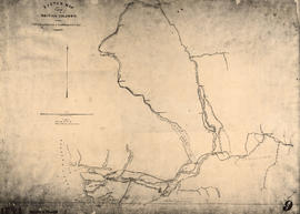
Sketch map of part of British Columbia showing trails and routes of communication
Part of Major Matthews collection
Item is a photostatic copy of a manuscript map showing trails and routes of communication in a portion of British Columbia from the Canada-U.S. border in the south to Seaton Lake in the north, and from the coast to Vermillion in the east. The section of coastline extends from Semiahmoo Bay in the south to Point Atkinson in the north. Map shows the location of mule trails and wagon roads, and includes a trail in progress from New Westminster to Burrard Inlet (North Road), trails from Whatcom to Hope and Semiahmoo to Derby, the Hudsons Bay Brigade Trail, Douglas Road, a trail proposed by Colonel Moody from New Westminster to Fort Hope, and the Dewdney Trail. Included with the map is a 1949 letter from Major Matthews, City Archivist, to J.M. Pearce in which Matthews describes the map, and a 1952 enquiry from L.B. [Housler] for a map showing the Dewdney Trail.

Part of City of Vancouver Archives technical and cartographic drawing collection
Map shows Hastings Town-site, Granville Town-site, Burnaby, and the City of New Westminster. Map also shows the Road from Granville and the False Creek Trail, as well as the names of places and soil types found along these roads. Other places and structures noted include Burrard Inlet, Coal Harbour (Coal Harbor on map), False Creek, False Creek Bridge, Burnaby Lake, Fraser River, New Westminster and Burrard Inlet Road, Douglas Road, Edinburgh Street, Columbia Street, Richards Street, and the New Westminster Cemetery. Two notes on map read "Plan to accompany Report of 1st May 1883, Joseph Hunter" and "Memo: Mr. Ross will place [?] this map to the [Engs.] Office Victoria [?]." 14T3 Roads & Trails is printed on the side of the map.

Part of City of Vancouver Archives technical and cartographic drawing collection
Map shows present and proposed roads of the Lower Mainland and northern Washington State, as well as road repairs. Map covers the area from Point Grey to Hope and from Burrard Inlet to Bellingham Bay. Trails and roads indicated on the map include Telegraph Trail, Waggon Road and Pitt River Waggon Road, as well as several unnamed trails. Major bodies of water indicated on the map are Burrard Inlet, False Creek, Burnaby Lake, Pitt River, Fraser River, Sumas Lake, Sumas River, Chulukweyuk River, Harrison River, Boundary Bay, Semiahmoo Bay and Bellingham Bay. Place names are indicated throughout the map. 11T3 Roads & Trails is printed on the side of the map.

Autumn in Stanley Park, Vancouver, B.C.
Part of Major Matthews collection
Photograph shows three men in a carriage on a dirt road surrounded by trees and bush. J.S. Matthews' notes with print or negative in Archives.
![[Woman standing on path] Stanley Park, Vancouver, B.C.](/uploads/r/null/e/f/ef88f6091a23e7328c8e48a8b0ed56ac4353ec06cd2bc4b954102aa77926bc9d/459a380b-894a-4ca4-aa24-5cdb1ac6e740-A04015_142.jpg)
[Woman standing on path] Stanley Park, Vancouver, B.C.
Part of Major Matthews collection
Photograph shows a mounted photograph, surrounded by flowers.

Rustic bridge. Stanley Park, Vancouver, B.C.
Part of Major Matthews collection
![[Men and women standing on trail at Stanley Park]](/uploads/r/null/f/a/fa6f5f79acc7cf977815f3356d745b18c689f6d293be9af218c2b3b39c02472b/4c70017d-7acc-47ee-863d-869539dd7633-A04021_142.jpg)
[Men and women standing on trail at Stanley Park]
Part of Major Matthews collection
J.S. Matthews' notes with print or negative in Archives.

Part of Major Matthews collection
J.S. Matthews' notes with print or negative in Archives.
![[C.P.R. construction trail in mountains]](/uploads/r/null/2/8/287d2a5424b7acf5119010b9aa841746490e130012987c63dc667ea6e5bdbc8f/081070d9-5cc5-4b91-ae24-d57d57d07c4c-A04197_142.jpg)
[C.P.R. construction trail in mountains]
Part of Major Matthews collection
J.S. Matthews' notes with print or negative in Archives.
![[Woman on path at Brockton Point] Stanley Park, Vancouver, B.C.](/uploads/r/null/5/0/502014bde480027c6c971f06a7ba5782198be8cd870d41d923f08d60cab6d080/fcec5119-a5d6-44fc-9eeb-7f5918a72a9b-A04012_142.jpg)
[Woman on path at Brockton Point] Stanley Park, Vancouver, B.C.
Part of Major Matthews collection
J.S. Matthews' notes with print or negative in Archives.

Rustic bridge. Stanley Park, Vancouver, B.C.
Part of Major Matthews collection
![In the forest [at Stanley Park showing an old logging road and skids]](/uploads/r/null/6/f/6f8d2299d299a608077d95982fb4f570321947c778ff7515fc115c588949c78c/48e6f436-6352-4ba5-a94a-2a097c4ec7a0-A21481_142.jpg)
In the forest [at Stanley Park showing an old logging road and skids]
Part of Major Matthews collection
![Which road? [Woman standing at a fork in the trail at Stanley Park]](/uploads/r/null/6/2/6250692a9c7c71b5412c44959ba1a4f11af91e579f1aed4fb0fcd696d3d3496f/e50948ec-0823-4745-954f-7530c6ecbbf4-A21491_142.jpg)
Which road? [Woman standing at a fork in the trail at Stanley Park]
Part of Major Matthews collection
![[Benches along trail in Stanley Park]](/uploads/r/null/b/7/b70ae5952d325b9baa97932b8529f242a0c270b869a92d2a06faa0aec19c313b/ebb77758-01cf-47f4-8211-b426d692f9b9-A08069_142.jpg)
[Benches along trail in Stanley Park]
Part of Major Matthews collection
J.S. Matthews' notes with print or negative in Archives.

The Bridge Across Porcupine Creek
Part of Major Matthews collection
Photograph shows W.H. Lang and party
![Winter Trail on Skaguay [Skagway] River](/uploads/r/null/6/7/674b4bdbec738165c57c0f2d54e15dbfbd1420b9bebe68e88fda401d840b5a64/0370f36b-9041-4f42-8b23-bef2cf53cf27-A37393_142.jpg)
Winter Trail on Skaguay [Skagway] River
Part of Major Matthews collection
Photograph shows W.H. Lang and party
![Winter Trail Through Box Canyon on Skaguay [Skagway] River](/uploads/r/null/0/7/0785fff790a14b7292efb2e43528871758ca896d378d36efa7593e2cec6e5dd7/67f52ed1-58bf-4a07-ba69-a2b9eefb6439-A37395_142.jpg)
Winter Trail Through Box Canyon on Skaguay [Skagway] River
Part of Major Matthews collection
Photograph shows W.H. Lang and party
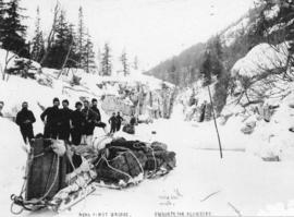
Near First Bridge En Route For Klondike
Part of Major Matthews collection
Photograph shows W.H. Lang and party
![At The Cutoff Skaguay [Skagway] Trail](/uploads/r/null/b/7/b799893aa32e56051e2204b1d1b090f413674f416b42ae10b65eefb72c815edc/c1c4b0bd-3c4f-494c-97c2-603b5b3b99d0-A37402_142.jpg)
At The Cutoff Skaguay [Skagway] Trail
Part of Major Matthews collection
![Skaguay [Skagway] Trail Alaska](/uploads/r/null/d/9/d9b982a440c6ef469ce847f748a73fd53af9e692f76d53eda0ed19410e2486d7/7f7e1f00-b536-4134-94c8-b9788ea30c08-A37394_142.jpg)
Skaguay [Skagway] Trail Alaska
Part of Major Matthews collection
Photograph shows two dead horses
![[Woman on path at entrance to Stanley Park]](/uploads/r/null/0/9/096250a50f9400c768a91da2b13a285033291a21f9933157296482b98291ffe9/dab8fa03-2bdc-44dc-969b-d6cc8a30771c-A09694_142.jpg)
[Woman on path at entrance to Stanley Park]
Part of Major Matthews collection
![[Woman at wooden staircase near path, Stanley Park]](/uploads/r/null/4/5/457c89c6028bf23763596d6fdc697d21ae95ab0da8b9e499329612e0e3d1d93d/2e27cf54-52d9-4482-9bfd-70bb3ab160bb-A04017_142.jpg)
[Woman at wooden staircase near path, Stanley Park]
Part of Major Matthews collection
J.S. Matthews' notes with print or negative in Archives.
![[View of pack horses on trail to Mount Robson]](/uploads/r/null/4/4/44ea22d884ceb88a1652ac725fbea5dc9917a2f57dd1c2dabb04f601d2c9ac37/e59e9b28-f3dc-40c5-99e2-07eb2a42c6db-A32802_142.jpg)
[View of pack horses on trail to Mount Robson]
Part of Major Matthews collection
Photograph shows an avalanche area
![[Sun shining on trees and trail in Stanley Park]](/uploads/r/null/a/c/ac09cdb852145a6cb7cab240ecf290cc6da15025bfb06ffe48e71fad8affff8d/4cec3db9-3041-4102-87f4-608857193ab8-A02303_142.jpg)
[Sun shining on trees and trail in Stanley Park]
![[View of path and beach at] Stanley Park](/uploads/r/null/3/a/3aa0c6077e47f7d0def9ff0528c568c8ca0459362557f2b3add0ac28e18c5e09/64890d47-0b29-4866-85df-e15fdc45b171-A02314_142.jpg)
[View of path and beach at] Stanley Park
![[Forest path by gazebo]](/uploads/r/null/e/9/e9137bf721bea15ecbf4ccb83f9a84ae3982f366414e560ae19db9a13ce0a8ac/a0f75382-b264-4563-a550-829de6776894-A01968_142.jpg)
Photograph shows a wide path through the trees next to a small gazebo.
![[Walking path]](/uploads/r/null/b/9/b90a505ee14f258a5cfe66d6d1b58f8f69da984139e043efdbe5bc0cbd401347/b96a8dca-3915-4b90-8083-c9b6a7dfa4e4-A01980_142.jpg)
Photograph shows a man standing on a wide path through a forested area.

Winter in the park, Vancouver, B.C.
Part of Major Matthews collection
Photograph shows a man walking down a snow covered trail.
![[Man and woman on horseback at Stanley Park trail]](/uploads/r/null/6/1/61bca704acddd2925838958fe6c43d3dbbd87911cc0bda8b32f5ea42f131d238/adc3fdf9-e67e-45e5-9a71-b58ddd5a861b-A02319_142.jpg)
[Man and woman on horseback at Stanley Park trail]
![[Snow-covered trees and path in Stanley Park]](/uploads/r/null/e/b/ebb3146784d3bceef350586c11bfac5d2f98e80fa102bed897651602b161b358/58bcffaa-3b59-4692-87b9-de753fb5760d-A02300_142.jpg)
[Snow-covered trees and path in Stanley Park]
Photographs in album show various areas and scenes in Stanley Park, including: entrance bridge, a path next to a gazebo, a picnic area among trees, the road to the resevoir, a group assembled in a clearing, a pedestrian bridge, the seal pond, a wooded area, a boat in Coal Harbour, a dirt road, a horse-drawn buggy crossing a wooden bridge, a moss grove, Hallelujah Point, a walking path, a beach, and a view of the surf.
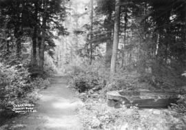
Cedar walk, Stanley Park, Vancouver, B.C.
Attached label reads: "Thirty-seven years ago in Stanley Park. Along the trail to 3rd Beach, about 150 feet west of the clump of Fir trees called the Seven Sisters. This is the remains of an Indian dug-out canoe that was abandoned on account of "dry rot" in the log. What is left of it is covered with dense green moss. The newly chopped chips were lying about when I made the above photograph. Philip Timms."
![[Pedestrian and equestrian paths in Stanley Park]](/uploads/r/null/8/3/83a243e5a3de71d2b7444225994b3426698fc8a6c4ea7bdc87f5d72790553386/c78fa8b3-904b-4f42-a262-cf821908634f-A02311_142.jpg)
[Pedestrian and equestrian paths in Stanley Park]
Photograph shows two paths, side by side, separated by a wooden railing. Two men on horseback are on the left path, and a man and boy are on the right path.
![[Snow-covered trees and trail in Stanley Park]](/uploads/r/null/3/3/338b72131ed7ad44e8d79092d193d2a49236ddd118eb855ffac537563959c7b5/d7714a77-d89d-42d1-88b9-1d6e56b4c968-A02302_142.jpg)
[Snow-covered trees and trail in Stanley Park]
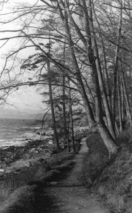
![[Trail along beach in Stanley Park]](/uploads/r/null/8/8/88bcab166e61dd7d1c620d8ecb464e199095d0d2e6fe25fa9f2a25fb7c85a0f1/01624d79-0f60-4b15-b59b-a28f39cd7707-A02572_142.jpg)
[Trail along beach in Stanley Park]
![[Walking path in Stanley Park, surrounded by trees and ferns]](/uploads/r/null/6/a/6a02fa01b89bd9e64dc8860eff82e1cc122389f3ec9f3766e543f4095fb19bb6/2f46a38b-bd05-4e52-b462-e10837340dcc-A02304_142.jpg)
[Walking path in Stanley Park, surrounded by trees and ferns]

![[Trees and section of seawall] Stanley Park](/uploads/r/null/e/f/efbae323723982ea66beb442ede1586efb8c0141876e371c048e7cba3286b3b6/ad79e5e6-7d83-4584-ad3d-fd2b9cb36654-A07695_142.jpg)
[Trees and section of seawall] Stanley Park
Part of Major Matthews collection
J.S. Matthews' notes with print or negative in Archives.
![[Split logs laid down to form a path through forest]](/uploads/r/null/a/9/a9421aac3e5fe668e75422b796bfd571005fc914c04f908733d10afbf3821dd5/92fa2da2-ac1a-4967-8e40-d41f78135dc0-A04795_142.jpg)
[Split logs laid down to form a path through forest]
Part of Major Matthews collection
![[Man seated at edge of path leading to St. Alice Hotel, Harrison Hot Springs]](/uploads/r/null/2/e/2e934fe9d54768bb9d1e1a0a33a533bc0881d9fa4d70d14ba790e28c0bb9a5e1/51c9c96b-c0e2-411f-b0e5-c8c179f2176b-A04506_142.jpg)
[Man seated at edge of path leading to St. Alice Hotel, Harrison Hot Springs]
Part of Major Matthews collection
J.S. Matthews' notes with print or negative in Archives.
![[Man standing next to large tree near trail]](/uploads/r/null/3/0/30e5e69b62e1658fb3b42dcd70ee275a60e46fd08f33479a7902c416647715ca/72d9174f-d969-4ce3-8d2d-a96fc4f21098-A04718_142.jpg)
[Man standing next to large tree near trail]
Part of Major Matthews collection
![[Snow-covered trail in Stanley Park]](/uploads/r/null/a/a/aa7f30d111c46b5900cd46ec0668aaea038c6862eecce7b96c5d5f54fb646f29/2487dfba-f60c-4fb0-bd51-35ce5502694a-A02322_142.jpg)
[Snow-covered trail in Stanley Park]
![[Trees and path in Stanley Park]](/uploads/r/null/4/0/409d9957d536449c8af4b0c319f8e89ecca52a43bcee5efa472996c56469bdbc/abe4c59e-0a6e-4e2b-be62-b5e8b1b70574-A02299_142.jpg)
[Trees and path in Stanley Park]


Photograph shows a walking path in Stanley Park near the first narrows of the Burrard Inlet.

Road to reservoir, Stanley Park
Photograph shows woman standing at wooden gate on a path through the trees.
Part of Major Matthews collection