
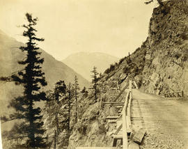
The wagon road at the 17 mile post - road to Goldfields
- AM54-S4-: Out P202
- Item
- [186-?]
Part of Major Matthews collection
Photograph shows a road on the side of a mountain
The wagon road at the 17 mile post - road to Goldfields
Part of Major Matthews collection
Photograph shows a road on the side of a mountain
Road Leading to Dockyard - Esquimalt
Part of Major Matthews collection
Photograph shows the telegraph office, church and other buildings.
![[A part of the Cariboo Road between Hell's Gate and Chapmans]](/uploads/r/null/0/9/09f564a5e10bf8b5b528d6cef608078781396fb613caaf73894b7adb3890e28a/20f81bdb-6c16-431f-a020-ec7dbd161749-A33841_142.jpg)
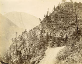
[A part of the Cariboo Road between Hell's Gate and Chapmans]
Part of Major Matthews collection
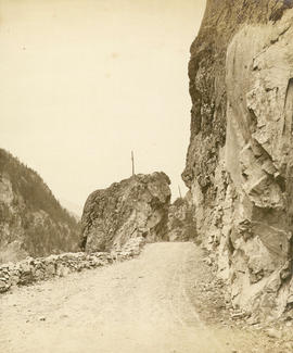
![[A part of the Cariboo Road]](/uploads/r/null/3/2/325b5ab94be7474ca99a4c6172efdaacbc096e5e7d14797a940ba9f1978735da/e943c3c1-170d-4b5c-a086-104eb24bb724-A33836_142.jpg)
Part of Major Matthews collection
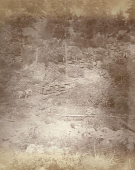
![[A part of the Cariboo Road]](/uploads/r/null/0/4/0451742b8f917ab9edd6b6e459fc385a9414ee9989dcb46d1e7183d293552284/cd8f24b9-f274-4655-bd36-999be6a1c680-A33839_142.jpg)
Part of Major Matthews collection
![[Nicaragua Bluff on the Cariboo Road]](/uploads/r/null/2/1/212ee267c1018cf936840d29525145920f13592d01c4166f02011afb7960667e/dfe8ff21-00f5-46e8-af64-5e05462e6164-A33842_142.jpg)
[Nicaragua Bluff on the Cariboo Road]
Part of Major Matthews collection
![[Hill 19 on the Cariboo Road]](/uploads/r/null/a/7/a7b7a913e1e5325c312ae63d254ada4c643f0714061a8c4eae87d2593375f76d/c51b19f1-c3f8-4602-ab31-e440fec83226-A33838_142.jpg)
Part of Major Matthews collection
![[The Cariboo Road between Hell's Gate and Alexandra Bridge]](/uploads/r/null/c/a/ca92cca8713ae10c685a422d7a45a7ee840c766362394ef7ed5e775c28cc9de9/3335f8a1-c7b7-46ce-af78-7823f86b7b38-A33840_142.jpg)
[The Cariboo Road between Hell's Gate and Alexandra Bridge]
Part of Major Matthews collection
![[Covered wagons being driven through Boston Bar]](/uploads/r/null/2/7/2757509c38f84a9ddd19e5303ed1d386c35620aac27004148c04f7724ee85944/b70f8e2c-e398-45ff-8666-7c062f9fd5a9-A33837_142.jpg)
[Covered wagons being driven through Boston Bar]
Part of Major Matthews collection

Great Bluff on the Thompson River
Photograph shows donkey-drawn covered wagons at 8 Mile Bluff

Nicaragua Bluff and wagon road from west side of Fraser River
Wagon road over Jackass Mountain

Boston Bar 25 miles above Yale
Photograph shows oxen-drawn covered wagons
Descent from the summit of road over Jackass Mountain
Photograph shows donkey-drawn covered wagons
![Wagon Road looking down [Fraser River]](/uploads/r/null/d/3/d31f33f3f68e921c25dc34269c92a6bbaa05550c337ff84c66b4e5640adc5d0d/6dbaba4f-967d-4271-857e-3299e25f0212-A19680_142.jpg)
Wagon Road looking down [Fraser River]
![Yale-Cariboo wagon road just above suspension bridge in the Black Canyon of the Fraser [River]](/uploads/r/null/1/f/1f9c184ef1eb9654c3fa89cda0e07c7c6f7427ebe2980cb8e38ea34299cd20b1/db892474-288e-48e6-9457-0e7c836aff1b-A19679_142.jpg)
Yale-Cariboo wagon road just above suspension bridge in the Black Canyon of the Fraser [River]
![Jack Ass Mountain - Frazer [Fraser] River](/uploads/r/null/c/7/c799a52649bb38a3bcb71ffb75a27c759ff6e8af804f850054196225049c2dd6/17f7922c-c502-4b65-aa24-6d977ba5cf71-A22919_142.jpg)
Jack Ass Mountain - Frazer [Fraser] River
Part of Major Matthews collection
Photograph shows donkey-drawn covered wagons
Nicaragua Bluff 13 1/2 miles above Yale

Summit of road over Jackass Mountain 48 miles above Yale
![China Bar Bluff - 28 miles above Yale on the Frazer [Fraser] River](/uploads/r/null/e/9/e9834f1ddcca28563493687bbfecb9567f9ba986b5c202f487df6365406543dc/a92c2367-8f8d-4de3-bbe6-978a47016230-A22918_142.jpg)
China Bar Bluff - 28 miles above Yale on the Frazer [Fraser] River
Part of Major Matthews collection
Photograph shows the cribbing supports for the "Waggon" [wagon] Road

Part of Major Matthews collection
Photograph shows a mule and covered wagon train in the distance beside Jackass Mountain
![[The Cariboo Road at Nineteen Mile]](/uploads/r/null/4/1/418b5bc66fd6c6308d93b02797fddf3bde764414fc361ca0b3480c9f1213aa23/a48be127-5cb2-454d-91a4-f5ac16d61091-A33950_142.jpg)
[The Cariboo Road at Nineteen Mile]
Part of Major Matthews collection

Map of New Westminster District, B.C
Part of City of Vancouver Archives technical and cartographic drawing collection
Item is a map showing District Lots in Vancouver, and township/range designations in other areas. The map also shows False Creek Trail, North Arm Road, False Creek Road, Granville Road from Granville to Hastings, New Westminster and Burrard Inlet Road, North Road, Semiahmoo Road, New Westminster and Yale Wagon Road, and others. Annotated by W. E. Graveley, 1885, to show additional features including Kingsway, Haney, Albion Camp, etc.
Trail over the big tunnel 15 miles above Yale
Photograph shows a pack-horse train

Part of City of Vancouver Archives technical and cartographic drawing collection
Map shows Hastings Town-site, Granville Town-site, Burnaby, and the City of New Westminster. Map also shows the Road from Granville and the False Creek Trail, as well as the names of places and soil types found along these roads. Other places and structures noted include Burrard Inlet, Coal Harbour (Coal Harbor on map), False Creek, False Creek Bridge, Burnaby Lake, Fraser River, New Westminster and Burrard Inlet Road, Douglas Road, Edinburgh Street, Columbia Street, Richards Street, and the New Westminster Cemetery. Two notes on map read "Plan to accompany Report of 1st May 1883, Joseph Hunter" and "Memo: Mr. Ross will place [?] this map to the [Engs.] Office Victoria [?]." 14T3 Roads & Trails is printed on the side of the map.

Part of City of Vancouver Archives technical and cartographic drawing collection
Map shows present and proposed roads of the Lower Mainland and northern Washington State, as well as road repairs. Map covers the area from Point Grey to Hope and from Burrard Inlet to Bellingham Bay. Trails and roads indicated on the map include Telegraph Trail, Waggon Road and Pitt River Waggon Road, as well as several unnamed trails. Major bodies of water indicated on the map are Burrard Inlet, False Creek, Burnaby Lake, Pitt River, Fraser River, Sumas Lake, Sumas River, Chulukweyuk River, Harrison River, Boundary Bay, Semiahmoo Bay and Bellingham Bay. Place names are indicated throughout the map. 11T3 Roads & Trails is printed on the side of the map.
![View [of] James Bay from Cathedral](/uploads/r/null/f/8/f8a9026b503bc411a11c5923bd34ed706cb7b09fa74b0c113690f17ea694da97/f8b38478-de71-4f6f-a240-a1bfcbbc9e7e-A19772_142.jpg)
View [of] James Bay from Cathedral
Part of Major Matthews collection
Photograph shows an arc lamp

Part of Major Matthews collection
Photograph shows a child on a wooden sidewalk
![[A portion of the Cariboo Wagon Road and C.P.R. tracks near Yale]](/uploads/r/null/2/7/2747c37503974ec2b3ad4de312385ad48ed50f25cc373022468810ff927fea7a/a58e14f6-d77f-4545-8123-45c6094f585e-A33095_142.jpg)
[A portion of the Cariboo Wagon Road and C.P.R. tracks near Yale]
Part of Major Matthews collection
![[Students of Esquimalt Public School]](/uploads/r/null/7/3/73190fd0eb4d7428d1977c1c9ab82db2ccc5be2dc2624e44e0afa7f805f3532b/22eb65ad-663a-447b-870e-f08c8f1c33f6-A36508_142.jpg)
[Students of Esquimalt Public School]
Part of Major Matthews collection
Photograph shows the road leading to the dockyard
![[Park Road at Brockton Point under construction]](/uploads/r/null/3/0/303fb80d7dc376a51bfc34a222fa8d1715c9c8539dae04caae702b9affc039a2/141be698-5c82-413c-a4ff-e32a6e5b7a99-A36824_142.jpg)
[Park Road at Brockton Point under construction]
Part of Major Matthews collection
Photograph shows the barque "Robert Kerr" in the distance

Map of the municipalities of New Westminster City and District, British Columbia
Part of City of Vancouver Archives technical and cartographic drawing collection
Part contains a map of the Lower Mainland and Fraser Valley from the Gulf of Georgia in the west to Harrison Lake in the east. Map shows locations of churches, schools, canneries, sawmills, brickyards, tanneries, woolen mills and hatcheries; existing and proposed railways; and roadways.
![[Women and children on road near Prospect Point]](/uploads/r/null/c/d/cdb348e7008d9327ba12370e8daf4cc18d75debfcd5d443b43279132ddb96dc3/f83f81ca-af8b-48c3-8db2-aa8ec421ef50-A36783_142.jpg)
[Women and children on road near Prospect Point]
Part of Major Matthews collection
Photograph shows Mrs. W.T. Dalton, A.T. Dalton, Joy Dalton and others
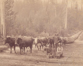
Logging Scene Near Vancouver, B.C.
Part of Major Matthews collection
Photograph shows loggers and a team of oxen on a skid road at Charleson's logging camp
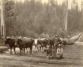
Logging Scene near Vancouver, B.C.
Photograph shows a team of oxen hauling logs on a skid road
![[A team of oxen on a skid road in Oben's Camp in the West End]](/uploads/r/null/d/6/d60bffa46dd5270b6b108f58f23dd9fabcd7b25d637b5f77d4fdac1da587267f/4b4b6f37-1973-4edd-bd27-2d096229a9f9-A37320_142.jpg)
[A team of oxen on a skid road in Oben's Camp in the West End]
Part of Major Matthews collection
![[Two women standing on dirt road at Brockton Point], Stanley Park, Vancouver, B.C.](/uploads/r/null/1/9/19c490cb9966c5e557122e85919e66c5b45e9efcdd0a79eb97fe8e189a6fc039/d0478418-e83e-4b60-8975-9452a792bab5-A04011_142.jpg)
[Two women standing on dirt road at Brockton Point], Stanley Park, Vancouver, B.C.
Part of Major Matthews collection
J.S. Matthews' notes with print or negative in Archives.
![From Park Road, Showing Mission [in North] Vancouver](/uploads/r/null/e/a/ea84794d38d5194b79fb6f1d973a13b703523d6a784b302853d965a53b82552c/300ce682-c55a-4925-9c09-1f6f96286f95-A36844_142.jpg)
From Park Road, Showing Mission [in North] Vancouver
Part of Major Matthews collection
![[North Arm Road (Granville Street) looking south]](/uploads/r/null/0/6/06146ca573f45fb59102abd2b3168cedd6e10e0364161fee86d4085bc2598f22/e12a9179-9a90-4153-a43e-628b48aeb690-A37069_142.jpg)
[North Arm Road (Granville Street) looking south]
Part of Major Matthews collection

Part of Stanley Park Road on Brockton Point Vancouver, B.C.
Part of Major Matthews collection
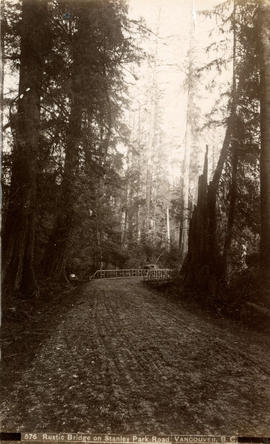
Rustic bridge on Stanley Park Road, Vancouver, B.C.
![[Two men playing cards in the middle of a logging road in Stanley Park]](/uploads/r/null/8/5/853bc7a57f8925e2b9214b7d7450e776e4e7d8ed0f2beeb9abc0d0c8cd6dc2cb/399b3920-a0a9-4138-938b-f0a4df1bc39f-A04043_142.jpg)
[Two men playing cards in the middle of a logging road in Stanley Park]
Part of Major Matthews collection
J.S. Matthews' notes with print or negative in Archives.
![[Team of oxen hauling logs on skid road in Kitsilano]](/uploads/r/null/9/9/99a1e7471a705e9f2d0083187a73134d0cf384d58e75954cb84b063e44968f28/48ac0309-63c4-4f24-87e5-4928ace96b8e-A31956_142.jpg)
[Team of oxen hauling logs on skid road in Kitsilano]
Part of Major Matthews collection
![[Unidentified road in California]](/uploads/r/null/0/5/057f54e62f6da500562829bb64ac56f4ffeff0c775b31f3e798fc60860e163bd/43a45ace-8a29-4504-a0f4-9bd45ad52257-A19616_142.jpg)
[Unidentified road in California]
Part of Major Matthews collection

View of west end looking north west over Stanley Park
This photograph is the second of four images that create a composite panorama. These images include CVA 589-21 to CVA 589-24.
![[Two men playing cards in the middle of a logging road in Stanley Park]](/uploads/r/null/3/4/3435bc9d5836f4d390133f75cdaec49212ba63623bf5dbfa7728abcacdb84bbc/546e1768-7351-4ce6-86cc-79e19cb70a7c-A04044_142.jpg)
[Two men playing cards in the middle of a logging road in Stanley Park]
Part of Major Matthews collection
J.S. Matthews' notes with print or negative in Archives.

Part of Major Matthews collection
Photograph shows Park Road near Brockton Point

Illecillewaet River and C.P.R.
Part of Richard H. Trueman fonds
![[A waterfront settlement on Ladner Road near New Westminster]](/uploads/r/null/a/8/a8305e7e0c6a4ef2a4bea008bb865269b5263288137581bf21d79e72f1c36ccd/4c575fbf-d2ce-4159-95c7-8202db5c0a8b-A26748_142.jpg)
[A waterfront settlement on Ladner Road near New Westminster]
Part of Major Matthews collection
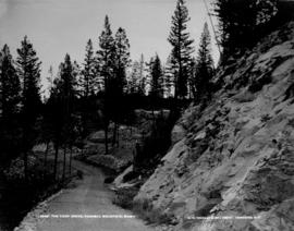
The Loop Drive, Tunnell Mountain, Banff
Part of Richard H. Trueman fonds