![[Driving the last spike of the Pacific Great Eastern Railway line 25 miles north of Horseshoe Bay]](/uploads/r/null/8/6/865249cd08465450446cf3fbba7cb5f3835813180d9172e6001e6fd65f64a12c/04e7f1a8-6f42-4a37-a8c0-632d0027d414-A37620_142.jpg)
[Driving the last spike of the Pacific Great Eastern Railway line 25 miles north of Horseshoe Bay]
- AM54-S4-: Trans P164.1
- Item
- June 10, 1956
Part of Major Matthews collection
Photograph shows Bill Smetanuch, Mr. Chetwynd and others
51 results with digital objects Show results with digital objects
[Driving the last spike of the Pacific Great Eastern Railway line 25 miles north of Horseshoe Bay]
Part of Major Matthews collection
Photograph shows Bill Smetanuch, Mr. Chetwynd and others

Part of Major Matthews collection

Part of Major Matthews collection
![[Debris over railway tracks during flooding of the Fraser River]](/uploads/r/null/0/1/01847f2fb7d8caf15febc73957867715f62869873b9c8413e3569950b84d26cc/0815196e-62eb-4206-b7ca-06a285886f49-A60577_142.jpg)
[Debris over railway tracks during flooding of the Fraser River]
Part of Major Matthews collection
![[Debris over railway tracks during flooding of the Fraser River]](/uploads/r/null/9/0/90fe092f5f241878f2ae538a7a6cb1e5e2158fd5ec080a774b31604183fd14bf/81f35939-d5d7-4ee7-ab59-85ae9e5c4602-A60578_142.jpg)
[Debris over railway tracks during flooding of the Fraser River]
Part of Major Matthews collection

Part of Major Matthews collection
Photograph shows Cambie Station
![[View of C.P.R. trestle bridge and "The Loop" in the Selkirk Range]](/uploads/r/null/6/6/66335f57d590f6a5878e272fb0b05cd9067fe8dedc99c86bd1d5f3d3447a6cac/0e41b794-df67-451f-8534-2fafc26fc50d-A25413_142.jpg)
[View of C.P.R. trestle bridge and "The Loop" in the Selkirk Range]
Part of Major Matthews collection
Photograph shows Cambie Station
![[The Glidden car on the C.P.R. line]](/uploads/r/null/9/2/92d9654b69d1c0026ff7f311f00265451aec1b1141313b53e85f8aecff7bc9a3/1a77fa4e-4ebc-4740-b354-408d8cd9c533-A37501_142.jpg)
[The Glidden car on the C.P.R. line]
Part of Major Matthews collection
![[A flat car on rails near Buntzen Lake]](/uploads/r/null/e/f/ef36a170a63a935a30c10ba410111411f26c6dee81f28781afc2c197c1dd0d07/f2d6e83d-addc-4d66-b8df-4a49f6da1031-A23290_142.jpg)
[A flat car on rails near Buntzen Lake]
Part of Major Matthews collection
![[Elevated rails at the Buntzen Lake Dam construction site]](/uploads/r/null/9/9/99f876a0f7c5ea020f86be1134bd5ee9f41dbeefffe4a5bead61539e75c10301/df189970-2db0-4372-90fd-d40ff41ccf45-A23312_142.jpg)
[Elevated rails at the Buntzen Lake Dam construction site]
Part of Major Matthews collection
![[Buntzen Lake Dam under construction]](/uploads/r/null/8/9/89e05851fc9849500789e66325ccbb0dab13cebec4618829b8683b45363b0e5e/16b1c6e9-1b1d-4efe-9699-11f9b4398b52-A23315_142.jpg)
[Buntzen Lake Dam under construction]
Part of Major Matthews collection

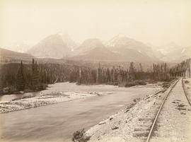
The Kicking Horse River, C.P.R.
Part of Major Matthews collection
![[Floating rails on Buntzen Lake]](/uploads/r/null/9/4/94d3de2029b4cefd1b7c3546b7a0c026c33eb4536b25774518bee87d95505802/a703e912-68eb-465f-8c81-a88683ee637c-A23296_142.jpg)
[Floating rails on Buntzen Lake]
Part of Major Matthews collection

Part of Major Matthews collection
![[Flooding] East of Agassiz](/uploads/r/null/9/0/9026779ba4b27629323676cc03d3d37ba9282654f12d890d7d481a72c1b3b3cf/a825f68e-00ee-4198-8bc4-3ebef6aeb9b5-A33076_142.jpg)
Part of Major Matthews collection
Photograph shows men in a rowboat
![Harrison [River flood]](/uploads/r/null/e/7/e7e8221ae477cb44cccb068dd6aeca6b37be6c20182d659cbef886ad14593b9c/480e6c13-3fcc-4887-8b70-0341237bc377-A33074_142.jpg)
Part of Major Matthews collection
![[Flooding] West of Harrison [River]](/uploads/r/null/1/5/1585f33739747cd7f7d0cdc779abda00522bfe13d09630d253e504b7de4b5752/3e0d9626-58af-4fb8-b92e-dbf04fd1ecc1-A33073_142.jpg)
[Flooding] West of Harrison [River]
Part of Major Matthews collection

Stoney Creek Bridge C.P.R. Selkirks
Part of Major Matthews collection

Stoney Creek Bridge, Selkirks 296 Feet High
Part of Major Matthews collection

The Loop C.P.R. Selkirks showing four tracks
Part of Major Matthews collection
Photograph shows a trestle bridge

The Loop C.P.R. Selkirks showing four tracks
Part of Major Matthews collection
Photograph shows a trestle bridge
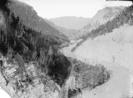
Bird's eye view Lower Kicking Horse Canyon
Part of Major Matthews collection
Photograph shws bridge, railway tracks and river through canyon.

Sailor Bar Bluff, Fraser Canyon, B.C. C.P. Ry.
Part of Major Matthews collection

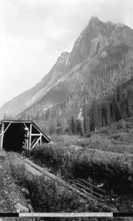
Snow shed and tunnel, Illecillewaet Canyon, Selkirk Mts.
Part of Major Matthews collection
![Mount McDonald [MacDonald], C.P.R., Selkirks, midwinter, height 9440 ft.](/uploads/r/null/a/b/ab2a6f9761da72be5b95cc7c26b9134cbc9556ef110fbbd2a31bb79f4a574ee5/63e110ea-430d-46c2-add5-934dd2594853-A04166_142.jpg)
Mount McDonald [MacDonald], C.P.R., Selkirks, midwinter, height 9440 ft.
Part of Major Matthews collection
Photograph shows snow-covered railway tracks and shelter in foreground and mountain peak in the distance.

Workmen improving bluff at "Cariboo Joe's" tunnel, C.P. Ry.
Part of Major Matthews collection
Photograph shows men with loads of rock on tracks next to cliff.

First Curve on Loop Going West, Selkirks
Part of Major Matthews collection

Ross Peak, C.P.R. Selkirks, Midwinter
Part of Major Matthews collection
Photograph shows a railway snow shed
![[Railway line running through valley]](/uploads/r/null/7/6/7613f21b564d8dbf7a428c8bc0a4c6d729a59966e23d927250a0f9662d13d2d4/04f8e04b-f467-48a5-8642-fb434574329c-A04517_142.jpg)
[Railway line running through valley]
Part of Major Matthews collection
J.S. Matthews' notes with print or negative in Archives.

Part of Major Matthews collection
Photograph shows railway track running alongside river through mountains.
Mt. McDonald summit of Selkirks. Height 9440 ft.
Part of Major Matthews collection
Photograph shows railway tracks and shelter in the foreground, and mountain peaks in the distance.

Mount Hermit Summit of Selkirks Height 9680 feet
Part of Major Matthews collection

Part of Major Matthews collection
![[C.P.R. line through tunnels in mountain]](/uploads/r/null/f/8/f802e445bc29c0f27d847b0ce332297a0f6a0df7c77b32cf2de2d0c394b5f8b2/8905d2db-8786-4bc7-b04d-90363315a3f7-A07963_142.jpg)
[C.P.R. line through tunnels in mountain]
Part of Major Matthews collection

Ross Peak (winter) C.P.R. in Selkirks
Part of Major Matthews collection
Photograph shows three men standing next to snow shed over railway tracks.

Snow sheds on mountainside, Rogers' Pass, B.C.
Part of Major Matthews collection
Photograph shows sheds over railway lines on side of mountain.

Snow sheds. Summer and winter tracks of C.P.R. Summit of (Selkirks)
Part of Major Matthews collection
![Hermit Range, from summit of [Selkirks, C.P.R.]](/uploads/r/null/a/a/aaef5746df63939614fccd5d4a0c8a1417d3fa0c5dc24a6f2831154e619e4d52/e8367f9c-8d45-4d1b-8edf-37715a00045a-A07993_142.jpg)
Hermit Range, from summit of [Selkirks, C.P.R.]
Part of Major Matthews collection
J.S. Matthews' notes with print or negative in Archives.

Part of Major Matthews collection
Photograph shows area known as the Big Slide, Kicking Horse River, the slopes of Mt. Field (on right) and Mt. Burgess in the background.

Mt.Hermit. Summit of Selkirks. Height 9680 ft.
Part of Major Matthews collection
Photograph shows railway tracks in foreground and mountains in the distance.

The Loop, C.P.R. in the Selkirk Mountains, B.C.
Part of Major Matthews collection

Hermit Range and snow sheds, from summit of Selkirks, C.P.R.
Part of Major Matthews collection
Photograph shows snow sheds and railway tracks in foreground, and mountain range in the distance.
![[An unidentified trestle bridge]](/uploads/r/null/3/9/39fdfa01a84339614eb65f280a452762a43e4d2ca6702d013f6aab7d6d942585/af3f3987-8c1b-41a5-a221-c2508a177dab-A62874_142.jpg)
[An unidentified trestle bridge]
Part of Major Matthews collection
![[An unidentified trestle bridge]](/uploads/r/null/e/b/eb0d4c8b0dae85193566cd43b486ff6bbfed301718582e19f02af491568cc2fb/0ad7459c-1972-4393-bca8-624dbe2c4fe4-A62875_142.jpg)
[An unidentified trestle bridge]
Part of Major Matthews collection

Mount Hermit, C.P.R., Selkirks, Midwinter, Height 9680 feet
Part of Major Matthews collection
Photograph shows a snow shed

Part of Major Matthews collection

Part of Major Matthews collection
![Sailor Bar Bluff [in the Fraser Canyon]](/uploads/r/null/2/7/2756008117b1cacdfb661cb8721f6127b3ca3fdd00971d10488cb41fa0368b12/ec0f6a17-6a63-4e3f-8ad3-397813c040fa-A19747_142.jpg)
Sailor Bar Bluff [in the Fraser Canyon]
Part of Major Matthews collection
Part of Major Matthews collection
![Devil's Gap [and] Beaver Canyon View No. 2](/uploads/r/null/4/4/44d0528e595370f28fc2340079698113fd07efcd4c94dca50739bca01fccf576/c7c99282-4843-4adf-822c-539477e63eb9-A19771_142.jpg)
Devil's Gap [and] Beaver Canyon View No. 2
Part of Major Matthews collection
Photograph shows 5 men standing beside the canyon. The canyon is located in the Selkirk mountain range.