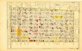
Sheet 10 : Clark Drive to Slocan Street and Burrard Inlet to Triumph Street
- COV-S303-MAP 343-: MAP 343.12
- Item
- [ca. 1925], with revisions to Oct. 12, 1938
Part of City of Vancouver fonds
Item is a section showing the area from Clark Drive to Slocan Street and aterfront to Triumph Street. Includes streets and roads, blocks, lots, legal descriptions, railways, parks, boys' detention home and businesses along the waterfront. The Town of Hastings is indicated on the map. Map is hand coloured to show tax sale property for sale, property with no water, street widening and drainage, replotting, reserved land for schools, reserved land for parks, sundry land, capital assets not including schools and parks, schools, and parks, as applicable.
Vancouver (B.C.). Office of the City Engineer