
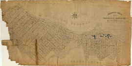
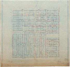
Topographic map of Downtown Vancouver and the East End
- COV-S365-: MAP 698
- Item
- 1887-1913
Part of City of Vancouver fonds
Item is a map showing two sets of topographic contour lines, streets, and block numbers (in Roman numerals) in the area from Robson Street to Raymur Avenue and Coal Harbour/Vancouver Harbour to False Creek.
![[200 block Kingsway]](/uploads/r/null/7/7/77394b8f6743426401ba89776a603af6113100f7e0353fc7d5472c96400bd87d/f14b09f3-f973-445e-a163-a97329a90eea-A16549_142.jpg)
![[View of fire at G.H. Cottrell Warehouse, 139 Water Street]](/uploads/r/null/d/4/2/d42e9cc6d0ed113b820738761abee8e002b3343ece277b2d2aa63d56af341039/38d982ad-3791-47df-aa20-a24e3dff0244-CVA354-018_142.jpg)


![[Looking west towards the southwest corner of the 2400 Block Kingsway at Broadway]](/uploads/r/null/a/e/aef43aff9ffe4f4e13146bc92fe519874797f4e7103237fe9bbacdbb5286405a/c5714b94-93cd-49b0-8d4d-6b73282b3f69-A16548_142.jpg)


![[100 block Pender St.]](/uploads/r/null/a/7/a74d7295b32f5a3ff72238c96104b6fbc9389340b17b19a79228a52601a36e4d/dd7ccf36-0ac7-4e5c-b777-a705563d3718-A16540_142.jpg)
![[People on street in front of Union Bank of Canada at Hastings and Main]](/uploads/r/null/4/7/47369ef87561a6883a1f5567410f57e1f8187bf212a98074c258d72e8d662262/b2d10f16-3526-4e34-82c6-90a116eaeaa3-A16546_142.jpg)