- AM54-S4-2-: CVA 371-2859
- Item
- [193-?]
Part of Major Matthews collection
206 results with digital objects Show results with digital objects
Part of Major Matthews collection
Part of Major Matthews collection
Item is a topographical map of the municipalities surrounding Howe Sound and Burrard Inlet. Municipal boundaries, roads and other transportation infrastructure, and radio stations are also included. The Greater Vancouver water supply areas and waterways are shown along with pipe lines, power lines and telegraph lines.
![[Boys Industrial School (Bisoq) chicken coop]](/uploads/r/null/1/1/112a23a35f3d1a16dbb2db2de91d77686ee903967444fb086fe4a3c0bd145b3b/6ece6e0c-a192-4d88-8cb3-f469a9b047d0-A60342_142.jpg)
[Boys Industrial School (Bisoq) chicken coop]
Part of Major Matthews collection
![[Dairy herd at the Boys Industrial School (Biscoq)]](/uploads/r/null/5/3/53de396b050559ca19d7b1bbb5b09598b1d61051a506764e6610d4d85c8f589d/05bf3a6a-67ec-4555-8e2b-babc7de6badf-A60329_142.jpg)
[Dairy herd at the Boys Industrial School (Biscoq)]
Part of Major Matthews collection

Boys Industrial School (Bisoq) champion Jersey steer
Part of Major Matthews collection
Major Matthews notes on the back state that it was a champion at the Vancouver Exhibition on two occasions.
![[Boys Industrial School (Biscoq) attendees marching in uniform]](/uploads/r/null/3/e/3e8d096370138513a3869fbb39c5f94cfadd13ed58b07ce4ed0de306a4a748b7/f4289af1-e548-4a8d-8159-719122b3eea8-A60156_142.jpg)
[Boys Industrial School (Biscoq) attendees marching in uniform]
Part of Major Matthews collection
Item is a photograph. Notes written on the back include: "Biscoq Boys coming from church about 1925"
![[Boys Industrial School (Biscoq) attendees perform callisthenics]](/uploads/r/null/4/4/4458ccb583e6777779320fdc1162493ec0c65bfec27aa39fba6c8050c4c0793e/c28a28af-30b4-4621-b4cc-aa70615ffc15-A60155_142.jpg)
[Boys Industrial School (Biscoq) attendees perform callisthenics]
Part of Major Matthews collection
![[Boys Industrial School (Biscoq) band at picnic]](/uploads/r/null/7/d/7d5f6f47b22e3c4b9effc47c1e3e9a1ef53d150d92489693ff9f1cca4ea03b22/37a88b2d-3a1f-4da4-a8d9-73414f4d814b-A60158_142.jpg)
[Boys Industrial School (Biscoq) band at picnic]
Part of Major Matthews collection
![[Boys Industrial School (Biscoq) building]](/uploads/r/null/6/c/6cad3a2914db04bfa428095bd1f53317dac262c805a6019c9d8f49981b7c587e/8927d123-25f5-4c6c-aaa5-b3488e4b557b-A60162_142.jpg)
[Boys Industrial School (Biscoq) building]
Part of Major Matthews collection
![[Boys Industrial School (Biscoq) swimming pool]](/uploads/r/null/3/c/3c332dcd8b03e52d9f42a154016500c02aefb73a91ef054a32fba6308b471b97/88570955-1b9a-4815-a1b8-1f3c31ad8940-A60163_142.jpg)
[Boys Industrial School (Biscoq) swimming pool]
Part of Major Matthews collection
![[Boys Industrial School (Biscoq) piggery]](/uploads/r/null/6/2/62a76ad9deafe6ea0a1720dfd3ce8b1a08a6f2222cc0f2288dd9de6065433f83/87c12621-5278-4ca0-b9e0-4d209faba6c3-A60164_142.jpg)
[Boys Industrial School (Biscoq) piggery]
Part of Major Matthews collection
![[Boys Industrial School (Biscoq) attendees in uniform at open-air church service]](/uploads/r/null/7/d/7d38f6127a290685c7b168aaaa61819eef4868927677be721a114201280861c4/66bbe667-4717-4f1f-9d4f-d41c8eb41b31-A60165_142.jpg)
[Boys Industrial School (Biscoq) attendees in uniform at open-air church service]
Part of Major Matthews collection
![[Colony Farm, Essondale]](/uploads/r/null/4/9/49ca347b1d6336824054e0003bc7f7418e7058a906209a19efc50b531fe56294/a066df13-42cd-4dc3-b368-777c4ffd3ab5-A09335_142.jpg)
Part of Major Matthews collection
![[Colony Farm, Essondale]](/uploads/r/null/c/0/c06802bbc37cdc2e840e3e0f3a7a3aac074a31a2734d852a0b010d8cece2528a/e89b41d0-a1bf-4ab2-8c3b-c956fa78fc26-A09336_142.jpg)
Part of Major Matthews collection
![[Boys Industrial School (Biscoq) administration building and grounds]](/uploads/r/null/d/4/d44492016eb47f5ac351e6143d7d20ccd08a676b856395255c849278d89f5522/fa9c0e94-b89b-4da0-a6a8-e79477bf08ee-A60161_142.jpg)
[Boys Industrial School (Biscoq) administration building and grounds]
Part of Major Matthews collection
![[Boys Industrial School (Biscoq) attendees in uniform]](/uploads/r/null/1/4/14bc285bfcaabb00844442f8fbbf9412501dd7480d8008190f5caa6e136cafd8/80fa715c-2d8b-4be0-8d14-175521be132c-A60157_142.jpg)
[Boys Industrial School (Biscoq) attendees in uniform]
Part of Major Matthews collection
![[Boys Industrial School (Biscoq) band]](/uploads/r/null/a/c/ac963f3033b822b16ef2c29fd44bdd00009b34260fd62f5ce564b2eeaa3a86c6/378d035f-70f6-4e26-ac4a-5c3a05276b13-A60341_142.jpg)
[Boys Industrial School (Biscoq) band]
Part of Major Matthews collection
![[Boys Industrial School (Biscoq) baseball team]](/uploads/r/null/3/0/30d5c12b1a004d1a702604fb7bb45a0ae62592559844253247c2357f248340c4/0d2d8d7c-254e-4ee7-8be0-52b2e388d4fc-A60160_142.jpg)
[Boys Industrial School (Biscoq) baseball team]
Part of Major Matthews collection
![[Boys Industrial School (Biscoq) buildings and grounds]](/uploads/r/null/3/6/36e3e81bd44b379bd2ec0fdfe5ac24884dfbb652d825791ded98fb8753261fec/70b5a658-5b82-4661-acc2-0de0aed20802-A60159_142.jpg)
[Boys Industrial School (Biscoq) buildings and grounds]
Part of Major Matthews collection
![[Exterior of Burquitlam Golf Club]](/uploads/r/null/5/2/52cad374c82f712aad3ef36e090db451b2a5e2739d06b9dca9987a83b3bb0301/04629f52-0d7b-41d9-9407-2dd20c9203b2-A25818_142.jpg)
[Exterior of Burquitlam Golf Club]
Part of Major Matthews collection
![[Two participants in the Pacific Northwest Golf Tournament at the Vancouver Golf and Country Club]](/uploads/r/null/f/0/f01a06024faed1a9cf9d524b08230fc4c1a6fb746294ecb417c8528a80b6d135/2dcacd13-ce35-4994-be35-0828f63221be-A36664_142.jpg)
[Two participants in the Pacific Northwest Golf Tournament at the Vancouver Golf and Country Club]
Part of Major Matthews collection
![[Pacific Construction] Ltd. shipyards, Coquitlam, B.C.](/uploads/r/null/9/8/985b67f3c4220d320e24bc5afdfa7b618678a09944ab4c1b707aa3e6b0b1f646/59be42aa-a305-4140-9197-e1a16d8bdc32-A31755_142.jpg)
[Pacific Construction] Ltd. shipyards, Coquitlam, B.C.
Part of Major Matthews collection
Photograph shows the shipyard and an unidentified vessel under construction.
![[Pacific Construction] Ltd. shipyards, Coquitlam, B.C.](/uploads/r/null/2/3/23b12422de6f98928067417871fac46daa8bb91ce302cf283f094b2c633a27a5/77025246-f808-4f8b-8ce3-8021cfbfae7a-A31757_142.jpg)
[Pacific Construction] Ltd. shipyards, Coquitlam, B.C.
Part of Major Matthews collection
Photograph shows the shipyard and an unidentified vessel under construction.
![[Pacific Construction] Ltd. shipyards, Coquitlam, B.C.](/uploads/r/null/e/2/e23c736e1add9ecf575d4b4c856156f914e1a1ccb7dc0c473a2dbb49b052d724/b4e15b64-ad12-48eb-83dc-8e26c2a37059-A31754_142.jpg)
[Pacific Construction] Ltd. shipyards, Coquitlam, B.C.
Part of Major Matthews collection
Photograph shows the shipyard and an unidentified vessel under construction.
![[Pacific Construction] Ltd. shipyards, Coquitlam, B.C.](/uploads/r/null/2/f/2f12cf893944fcd669af3702c34875c1cd8a3ca43308e89d5ccc416c2b7683d2/54751da9-1710-4a94-a0ed-82996493bb1f-A31756_142.jpg)
[Pacific Construction] Ltd. shipyards, Coquitlam, B.C.
Part of Major Matthews collection
Photograph shows the shipyard and an unidentified vessel under construction.
![[Ship builders on frame of the "Coquitlam City"]](/uploads/r/null/2/2/22050112e87d255dbb9cd2e2cd75c24830c15d3dea77dc96976235a7bf8b8537/1713ba93-094a-4edd-a4e5-07835b774523-A23918_142.jpg)
[Ship builders on frame of the "Coquitlam City"]
Part of Major Matthews collection
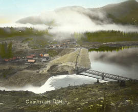
![[Three views of completed Coquitlam Dam]](/uploads/r/null/d/3/d3ceef2c5df82785038911ae627f004b66ce0d6dd6a650fb09b95305d0d03cbb/439a8aec-a8c4-41dd-ad0d-da7b600e775e-A08641_142.jpg)
[Three views of completed Coquitlam Dam]
Part of Major Matthews collection
Photograph is a copy of three photograph prints, showing: view along centre line of dam, showing water flowing over spillway in the foreground and bridge and reservoir to the right; view from lake side towards spillway, showing spillway bridge and gatehouse; and view of downstream side of dam from west bank, showing spillway through rock cup on the right and the borrow pit in the background. Negative was created to produce lantern slides of the three images.
![[View of Coquitlam Lake and Coquitlam Dam construction camp]](/uploads/r/null/6/4/64e606b65c399c06387e168ad6b94918ed882195c7d1542ea6be6d826cf213d7/33d7eb7a-d66e-4030-b056-d7bfe7234649-A08625_142.jpg)
[View of Coquitlam Lake and Coquitlam Dam construction camp]
Part of Major Matthews collection
![[Men sluicing materials in borrow pit of Coquitlam Dam]](/uploads/r/null/8/7/87c4a72df20a369713dafef523ff30543c2f8ce2d4a60b73cbed1f4150fba08a/9042673d-ee12-4d55-9081-5c3a46998f3d-A08414_142.jpg)
[Men sluicing materials in borrow pit of Coquitlam Dam]
Part of Major Matthews collection
![[Partially constructed Coquitlam Dam, looking east at edge of tree covered hillside]](/uploads/r/null/d/2/d25e9f0946b91c5196748e2803dfb1258451d97a2cbbfac5a0c597feb4afafd7/043df3c1-856c-46d0-bb24-3c7c3763b400-A08173_142.jpg)
[Partially constructed Coquitlam Dam, looking east at edge of tree covered hillside]
Part of Major Matthews collection
![[Partially constructed Coquitlam Dam, showing dam area and construction camp]](/uploads/r/null/9/9/99917fc064a831c320789979e28556ffd89b658a202746cfbe2675560bef65ff/a5fdb4c5-5f01-411e-8c31-a3ce2f51495c-A08415_142.jpg)
[Partially constructed Coquitlam Dam, showing dam area and construction camp]
Part of Major Matthews collection
![[Partially constructed Coquitlam Dam, showing trestle supported flume and hydraulic monitors]](/uploads/r/null/2/7/279816d1d9b1213f33d4efc3c8b247080894fcd9416cc3e0c74b7182ba3474a7/c007fe22-50ab-435e-97e0-b81e58ed5df2-A08643_142.jpg)
[Partially constructed Coquitlam Dam, showing trestle supported flume and hydraulic monitors]
Part of Major Matthews collection
![[Partially constructed Coquitlam Dam, showing trestle supported flume]](/uploads/r/null/e/e/eea2aaad046cdbdc9d9974557a57687887f715c8f18b11997fc82614f554c4d9/2bddfffa-e787-4903-8edd-c38dab33d07f-A08645_142.jpg)
[Partially constructed Coquitlam Dam, showing trestle supported flume]
Part of Major Matthews collection
![[Partially constructed Coquitlam Dam, showing upstream side of dam]](/uploads/r/null/f/f/ffea9158eb96d394ed5fca6d10a57e35757849cccc2b7d650cb69ffe52c26376/1e56a73e-6552-4f71-a03c-70dc21e52a1d-A08185_142.jpg)
[Partially constructed Coquitlam Dam, showing upstream side of dam]
Part of Major Matthews collection
![[Partially constructed Coquitlam Dam, showing upstream toe of dam]](/uploads/r/null/5/d/5d8be21eaef4e451d180e0951734a4204b7520be6223e3a19ed9bd02037f9880/6fc2e9c2-e54d-4ddc-8b33-3ad2cbef2606-A08181_142.jpg)
[Partially constructed Coquitlam Dam, showing upstream toe of dam]
Part of Major Matthews collection

[Four views of Coquitlam Dam and Buntzen Lake Power Plant number two construction
Part of Major Matthews collection
Photograph negative is a copy of four photograph prints, showing: early excavation at Buntzen Lake power house site; view looking up Coquitlam Lake from east end of dam, showing cleared shores that will be submerged when water levels are raised; trestle work for Coquitlam Dam; and downstream view of original Coquitlam Dam, showing construction sawmill in the background. Negative was created in order to produce lantern slides of the four images.

South end of Coquitlam Lake, taken from co-ord. 15.1090 on 4th July 1913
Part of Major Matthews collection

View of settling pond taken from 1200.0 looking to 1400.0 on 24th June 1913
Part of Major Matthews collection
Photograph shows water below flumes of Coquitlam Dam.
![[Coquitlam Dam site covered in snow, showing trestle supported flume and construction camp]](/uploads/r/null/2/6/26cc4207682974c3b3acca7d804196adf92b1104e2db7fb41904c1ef93b85cea/575132aa-d8cb-457b-83b9-c980b2d48163-A08393_142.jpg)
[Coquitlam Dam site covered in snow, showing trestle supported flume and construction camp]
Part of Major Matthews collection
![[Construction site for Coquitlam Dam, showing construction camp, flumes and borrow pit]](/uploads/r/null/a/4/a43891ec64e689b7fc278714422f4c19d234bde6b278150239dd3f926c02800e/60f385ff-d81a-4822-a316-bed08b74bf20-A08628_142.jpg)
[Construction site for Coquitlam Dam, showing construction camp, flumes and borrow pit]
Part of Major Matthews collection
![[Coquitlam Dam site covered in snow, looking west along line of upstream]](/uploads/r/null/6/f/6fd7373092a9199617307728b367620d4171d369a45eb20dea3815cefe30d0df/daf75950-fc82-4d3b-9234-d4b717515a2b-A08175_142.jpg)
[Coquitlam Dam site covered in snow, looking west along line of upstream]
Part of Major Matthews collection
![[Coquitlam dam site covered in snow, showing flume and settling pond]](/uploads/r/null/7/2/7290046aeac7b9dd5757700330bbfbe7b9c2f5836144c31dc1928bc869ec4dec/c8758a0b-8b5b-4e7a-9345-22e3674033cd-A08392_142.jpg)
[Coquitlam dam site covered in snow, showing flume and settling pond]
Part of Major Matthews collection
![[Upstream side of partially constructed Coquitlam Dam, showing construction camp in the distance.]](/uploads/r/null/4/3/43cc671badd77e361d87b3cd317e65d53cd33db0b026f90cef46a1bde0222d2b/13190360-0143-4959-aae4-bca645042c4e-A08634_142.jpg)
[Upstream side of partially constructed Coquitlam Dam, showing construction camp in the distance.]
Part of Major Matthews collection
![[Three views of Coquitlam Dam construction]](/uploads/r/null/2/f/2fd7a1be120558b3d8a3714b4414b301016a4594d2b78f1a2bb70fdc34008a93/de62e5e1-e756-4c0d-99c2-6c05562aeadc-A08636_142.jpg)
[Three views of Coquitlam Dam construction]
Part of Major Matthews collection
Photograph negative is a copy of three photograph prints, showing: view of upstream side of dam; view along centre line of dam; and view of downstream side of dam. Negative was created in order to produce lantern slides of the three images.
![[Road around mountain to Coquitlam Dam]](/uploads/r/null/0/9/09fe6eac46ebe49a22a0117d512c5bed232d0b2365dbbbc0dcf45759713f7413/2683899b-906e-41ae-acaa-9b2ad2e45ad5-A08413_142.jpg)
[Road around mountain to Coquitlam Dam]
Part of Major Matthews collection

View of settling pond taken from 750.0 looking towards 600.0 on 24th June 1913
Part of Major Matthews collection
Photograph shows partially constructed Coquitlam Dam, looking east on centre line of dam.

Panorama of dam site taken from co-ord. 2800.0 on 30th May 1913
Part of Major Matthews collection
Photograph shows partially constructed Coquitlam Dam, looking west on centre line of dam.
![[Headgate valve house for Coquitlam Dam]](/uploads/r/null/d/7/d76c0f060c69352eeb302e43eb66d476194b957ee03f20f8ff24a8b3ddfbd986/98acf23b-23aa-4b72-bbc9-043270442c25-A08631_142.jpg)
[Headgate valve house for Coquitlam Dam]
Part of Major Matthews collection
Photograph shows building containing valves used to control the outflow from the lake during dam construction. Photograph also shows rock cut for the permanent overflow spillway, and the riprap facing of the upstream side of the dam.
![[Partially constructed Coquitlam Dam, looking along centre line of dam site]](/uploads/r/null/6/0/60a4c05aef37c4de438bc07bf163ce88ac6e108ef00231e30303be193a05dd92/0f802d70-7d1d-4f64-b9e2-e5be261ca232-A08187_142.jpg)
[Partially constructed Coquitlam Dam, looking along centre line of dam site]
Part of Major Matthews collection
![[Partially constructed Coquitlam Dam, looking northeast toward borrow pit]](/uploads/r/null/c/f/cfadb4938a2de75c80db38f3de55a6fbbce5fcfb6fd7dee14c1660846f920d8a/40450e09-147f-4558-9770-23babed5225b-A08174_142.jpg)
[Partially constructed Coquitlam Dam, looking northeast toward borrow pit]
Part of Major Matthews collection