
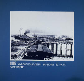
Granville... Foot of Abbott Street
- AM1576-S6-12-F12-: 2011-010.1834
- Item
- 1882 (reproduced ca. 1984)
Granville... Foot of Abbott Street

From Cordova and Seymour Street, site of C.P.R. Station

Corner of Georgia and Granville Streets looking east

Topographic map of Downtown Vancouver and the East End
Part of City of Vancouver fonds
Item is a map showing two sets of topographic contour lines, streets, and block numbers (in Roman numerals) in the area from Robson Street to Raymur Avenue and Coal Harbour/Vancouver Harbour to False Creek.

First continental passenger train arrives at Vancouver, May 13 foot of Howe St.

City of Vancouver, Canadian Pacific Town Site
Part of City of Vancouver Archives technical and cartographic drawing collection
The map shows the area currently occupied by Downtown Vancouver and parts of Kitsilano. It shows the location of C.P.R. Wharf, Royal City Saw Mills, Hastings Saw Mill and Wharf, Leamy and Kyle's Saw Mill and other saw mills. "Streets graded and side-walked marked thus . . . . .." An insert shows "Canadian Pacific Mail Steamship Lines" on a map of the world. The north shore of Burrard Inlet indicates the locations of "Indian Houses" and a mission church.

Hudson's Bay Company storefront at 150 Cordova Street
Item is a photograph of a group of men and horse carts posing outside of the Hudson's Bay Company general merchants at 150 Cordova Street, the first Hudson's Bay Company store in Vancouver.
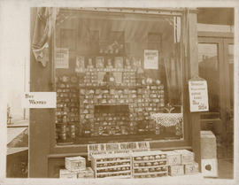
Window display of W.H. Walsh Grocer
Item is a photograph showing an exterior view of the grocery store window display and entrance doors. Displayed out front on the street are crates of apples and a sign for "Made in British Columbia Week"; advertisements for Malkin's tea, mince meat and a "boy wanted" sign are also visible. The business was located at 1200 Seymour Street, at the corner of Seymour and Davie.

Item is a map showing land subdivision in downtown Vancouver around Burrard Inlet, and the route of the Canadian pacific Railway along the south shore of Burrard Inlet.

Item is a photograph of a horse-drawn wagon for the parade. Inscription on verso states "Rec'd [Received from ex PC Ed Bellamore (PC126)".
![[Map of Pioneer Place showing the area deeded to the City of Vancouver by the C.P.R.]](/uploads/r/null/4/1/41ba387b96586eb8554abcbf013c0e5cfbb116a42c8d1d1d2311fb1856694b2a/e3bd79d3-cd72-42e4-aa51-bc080514c205-MAP780_142.jpg)
[Map of Pioneer Place showing the area deeded to the City of Vancouver by the C.P.R.]
Part of City of Vancouver Archives technical and cartographic drawing collection
Item is a hand drawn map of Pioneer Place (also known as Pigeon Park), on the corner of Hastings and Carrall Streets. Map is colour coded to indicate the portion deeded to the City by the C.P.R., the portion being asked from the C.P.R. for street purposes, and the portion leased by the C.P.R. to Mr. Horne. Included on the map are Horne Block, Garden Block, a sidewalk, lanes, and a fountain. An engineer's estimates of improvements are noted on the right side of the map. Notes at the top of the map by J.S. Matthews, City Archivist read "Presented in 1934 by Ex-Alderman W.H. Gallagher. The date is about 1895."

Tourist guide map of Vancouver City and Park
Part of City of Vancouver Archives technical and cartographic drawing collection
The map shows the area currenlty occupied by Downtown Vancouver and parts of Kitsilano. It shows the location of C.P.R. Wharves, Hastings Saw Mill and other saw and shingle mills. "Note, Electric street railway shewn in Red."

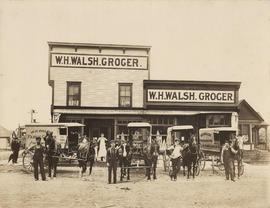
Exterior view of W.H. Walsh Grocer
Item is a photograph showing an exterior view of the building of W.H. Walsh Grocer store with employees and four of the store horse wagons in front. The business was located at 1200 Seymour Street, at the corner of Seymour and Davie.

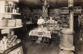
Interior view of W.H. Walsh Grocer
Item is a photograph showing grocery store employees and various canned goods and other items on display, including garden seeds and salmon, as well as a view of the cash register. The business was located at 1200 Seymour Street, at the corner of Seymour and Davie.
Interior view of W.H. Walsh Grocer
Item is a photograph showing a woman standing near displays of shoe polish, corn flakes and other goods. Other store employees are visible in the background. The business was located at 1200 Seymour Street, at the corner of Seymour and Davie.
Exterior view of W.H. Walsh Grocer
Item is a photograph showing an exterior view of the W.H. Walsh Grocer building and employees standing in front with four horse-pulled delivery wagons. A residence and parts of other houses are also shown. The business was located at 1200 Seymour Street, at the corner of Seymour and Davie.

Interior view of W.H. Walsh Grocer
Item is a photograph showing six employees standing behind the counter and displays of merchandise. The business was located at 1200 Seymour Street, at the corner of Seymour and Davie.
![Vancouver, B.C. Plan showing location of water pipes, hydrants, etc. [Burrard Street to Gore Avenue]](/uploads/r/null/7/7/7797d041e72dece35da90eab6733a9db50a0b2115ad816578d3633a58bf31761/ebc0f54a-c23a-425c-816d-1dd268a2e4e7-MAP72_142.jpg)
Vancouver, B.C. Plan showing location of water pipes, hydrants, etc. [Burrard Street to Gore Avenue]
Part of City of Vancouver Archives technical and cartographic drawing collection
Item is a map showing the location of water pipes and hydrants for the area Burrard Street to Gore Avenue (D.L. 541). Pipes and hydrants are shown in various coloured inks to indicate installation date.
Vancouver (B.C.). Water Works Department

Vest pocket map of Vancouver : map A
Part of City of Vancouver Archives technical and cartographic drawing collection
Part contains a key plan for the larger maps, textual information about Vancouver, and a map of the West End and downtown Vancouver.

Front facade, Vancouver Opera House, Granville Street

The Windsor Hotel, Granville St., with proprietor W.H. "Billy" Allen
Item is a photograph of The Windsor hotel with the proprietor, W.H. "Billy" Allen standing in the entrance. Visible to the left is a Coca Cola soda fountain stand with men standing at it.

Mr. E.R. Ricketts, manager of the Vancouver Opera House, in his office
![[Former] Post office building](/uploads/r/null/6/0/2/60250a52b6f591cc6fb7d222333429fa1f7105944f4745f2974840e95a9acb18/9f343a04-1c68-498b-82bd-0311e7092c7f-2015-028_142.jpg)
Item is a photograph showing the building exterior at the northwest corner of Granville and Hastings.
![SE [southeast] corner of Hastings and Granville](/uploads/r/null/2/1/3/213aba5e1226d4979e557097c33e200b69c59ad0e4b6f60cf774fa36ffad5a5a/13558724-7b14-4beb-a3f2-53e743d93cfa-2015-028_142.jpg)
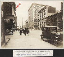
SE [southeast] corner of Hastings and Granville
Item is a photograph showing the Canadian Bank of Commerce, the Canadian Life Assurance Company, the Bank of Nova Scotia and other buildings, pedestrians, and street lights.
![Vancouver Police Patrol No. 1 [Police launch at dock]](/uploads/r/null/5/8/4/584e53989fbbacbc127136fa5099a82b57c4b803eea2d3e550f1b2197d83cef2/0b36a4a2-69fc-40e9-a972-dbe1d7babb51-CVA480-201_142.jpg)
Vancouver Police Patrol No. 1 [Police launch at dock]
Item is a photograph of a police patrol boat docked in front of the New England Fish Co. building ; two uniformed police officers are on the patrol boat and dock workers are in the background.

Window display of W.H. Walsh Grocer
Item is a photograph showing a window display of B&K rolled oats, National Mills flour and Canadian wheat flakes. The business was located at 1200 Seymour Street, at the corner of Seymour and Davie.

Exterior view of W.H. Walsh Grocer
Item is a photograph showing a group of grocery store employees standing outside of the W.H. Walsh Grocer. The business was located at 1200 Seymour Street, at the corner of Seymour and Davie.

First gas station - 234 Smythe at Cambie
Part of Imperial Oil Company fonds

Granville Street looking south from Dunsmuir
Item is a photograph showing the building exteriors of storefronts including Don't Argue Tobacco, Dr. E. D. Washington, Dentist, E.C. Kilby, F.W. Woolworth Co., and Toyo Oriental Goods and automobiles parked along the street and the Vancouver Block building at 736 Granville with the clock on top of the building.
![N. [north] West side of Granville between Pender and Dunsmuir](/uploads/r/null/8/7/a/87a2ab664827ceccee6e17982e1b2081805e4333f3b27ec545d905b5f0241585/6c519ed4-6cc2-4007-9ce2-56b27580bb67-2015-028_142.jpg)
N. [north] West side of Granville between Pender and Dunsmuir
Item is a photograph showing building exteriors of storefronts and signage including Grand Trunk Systems, Belding-Corticelli Limited and other shops.

Item is a photograph showing building exteriors of shops including Cunningham's Drugs, Leonard's Café, Credit Foncier and other businesses as well as a policeman directing traffic and pedestrians walking the streets.
Item is s photograph showing the building exterior at Granville and Pender.

Item is a photograph showing the building exterior of Birks Building at the corner of West Georgia and Granville.

Item is a photograph showing the building exterior looking east along Hastings at Howe Street.
![Granville Street looking [south] from the corner of Georgia Street](/uploads/r/null/5/9/1/5913f1c25cc5f98ccad7fc139a021d615694a2444dc474a8d68bad7ba26338d9/7a3b9c4b-4814-48a0-9e30-0b2b8c7796f7-2015-028_142.jpg)
Granville Street looking [south] from the corner of Georgia Street
Item is a photograph showing car traffic, pedestrians, street lights, the corner of the Hudson's Bay Company and other buildings along the intersection.
![Hotel Le Baron [Barron]](/uploads/r/null/d/4/d/d4d0ba70f935662b268da1b4af096fe215e7324f1571ffcfb184235ec1fbd4f1/7cc1f463-0c40-4e44-ab32-7cb927bfb998-2015-028_142.jpg)
Item is a photograph showing the exterior of the hotel building with sign, partially obscured, on rooftop. Storefronts are visible, including the hotel café, Cunningham's, and Glenaird Rooms. A typed description also states, "Note Kelly Douglas delivery van. They developed the Nabob brand of coffee. Their warehouse was in Gastown but is now out on Kingsway near Metrotown."

Granville Street from centre of 500 block looking south
Item is a photograph showing building exteriors, automobiles, pedestrians, and police officer standing next to traffic sign.

Hotel Dunsmuir, Vancouver B.C.

Robson and Granville looking north
Item is a photograph showing buildings along Granville, a policeman directing traffic, streetcars and people walking along the street.
![[Former] Court House](/uploads/r/null/5/3/8/5383dfe2909667f03689a2c9d561d981bc7669e58ef78b1ebd8675311a43ed19/cfd10e1e-a2d5-4ae5-88ea-5f254c4d5b5c-2015-028_142.jpg)
Item is a photograph showing the building exterior showing the former entrance to the old courthouse along West Georgia Street.
Looking south along Granville Street at Pender
Item is a photograph showing traffic, a horse-drawn carriage, and pedestrians and a few signs on storefronts such as Canadian Universal Film Co.
![Granville and Davie looking SE [southeast]](/uploads/r/null/d/e/3/de3eb2e03334aa5c8649d547e6f17055a49398ae94b66024e71f7092c7378cf6/61c01b06-4d93-48b7-a391-b14ed8b5c06c-2015-028_142.jpg)
Granville and Davie looking SE [southeast]
Item is a photograph showing the Bank of Nova Scotia, Douglas Thorley Building, and the Davie Vulcanizing Co. as well as pedestrians, automobiles, street lights, and electrical lines.

Looking south on Granville from Dunsmuir
Item is a photograph showing the building exteriors of storefronts including Don't Argue Tobacco, Binnings Ltd., Fletcher Bros., Burberry, Lyric Rooms and Toyo Oriental Goods as well as street signs, street lights, pedestrians, automobiles, and streetcar traffic.
Looking north up Granville Street to Roger's Building
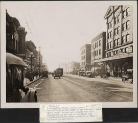
Granville Street looking south
Item is a photograph showing building exteriors, pedestrians, automobiles, a motorcycle, and streetcar.
![Granville Street looking S. [south] from Dunsmuir](/uploads/r/null/1/d/b/1db5b847301ded7210758f312af39befc83d07f7e4e83393ebc2975939b16beb/045153b9-5a19-4117-b905-545d99d26315-2015-028_142.jpg)
Granville Street looking S. [south] from Dunsmuir
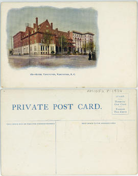
282 - Hotel Vancouver, Vancouver, B.C.
![N. [north] E. [east] corner of Granville and Dunsmuir](/uploads/r/null/4/d/b/4db2bf61ce11d1a916b9fd1476dc9f13d9a15730afb25e828c9dd88dffe692b0/aef5cfd2-bc44-4b29-9c1f-a9a6e60dafe6-2015-028_142.jpg)
N. [north] E. [east] corner of Granville and Dunsmuir
Item is a photograph showing building exteriors of the Bank of Montreal, Overwaitea and other businesses.