Projects no. 1 and 2 maps and plans
- COV-S305--
- File
- 1960-[ca. 1965]
Part of City of Vancouver fonds
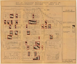
File consists primarily of maps pertaining to redevelopment project 1, areas A and D, but also contains two maps from project 2. Maps include identification plans of property to be acquired; boundaries of clearance areas; general and detailed redevelopment plans; and maps showing the layout of existing and proposed utilities.
![[2801 Hemlock Street - Chalmers' Presbyterian Church, 2 of 4]](/uploads/r/null/d/1/5/d15c3cd6cf47c1e7ef911325d81ef34f5d9ece4c74a8feea91608bfcd214c36b/7370db20-aa2b-43a4-992f-1f40c1ed6127-CVA1095-15225_142.jpg)
![[2801 Hemlock Street - Chalmers' Presbyterian Church, 3 of 4]](/uploads/r/null/b/b/2/bb2cc3329ec8e8b78889fa1a7b560da4bc109b02c76448e110c3f3afaa69f1ba/78a76433-bf78-4030-a64d-a6b870f9b0a1-CVA1095-15226_142.jpg)
![[2801 Hemlock Street - Chalmers' Presbyterian Church, 1 of 4]](/uploads/r/null/2/2/1/221bd390267cd0cec58410dd5f8035ee22b07ed46b6c1a3580fe2194eed5212a/4ea3f7c1-8120-425f-87a4-a515a4ee11e4-CVA1095-15224_142.jpg)
![[2801 Hemlock Street - Chalmers' Presbyterian Church, 4 of 4]](/uploads/r/null/4/a/1/4a1811e82599458aaae6322476e2a4807b46be62134cd6b405f6a5e5e09c894a/db1f7ff8-2960-4aa9-8612-8414f4b74899-CVA1095-15227_142.jpg)
![[846 West 8th Avenue]](/uploads/r/null/f/c/c/fcc80f968016ff8e7a4369515453245b557343a1fd2e37e9c03a039d2fe88b62/b2deee4a-6173-49af-a209-ee65bf17685f-CVA1095-00041_142.jpg)
![[745 West 8th Avenue]](/uploads/r/null/9/0/6/90685db0ef22c78d21107d53ddb293f793bfe4b986e22f6658900fe60939ff07/06e2d96d-af1e-4894-898b-1df369f5b7ed-CVA1095-00049_142.jpg)
![[944 West 8th Avenue]](/uploads/r/null/2/0/2/20295d0a91deafba5fd6f8363d9e8ad9066d66a7b816236fa4fcfbbd60f90fda/9979497e-fd4b-4188-a312-5348aa1f1e57-CVA1095-00053_142.jpg)
![[877 West 8th Avenue]](/uploads/r/null/3/c/0/3c0484469c4eeab4cef8cb86395fbf3f78208ab4f384fdb0924a9f3ef9fe6b60/8cc34431-137c-4639-a4a4-377aad809714-CVA1095-00059_142.jpg)
![[1023 West 8th Avenue - James Evans House]](/uploads/r/null/3/8/4/38401457016efe4753b1e42260f6feec7d3d90d070f27a371b7713877a6cc821/608f6224-996e-4402-8256-12f0ae934736-CVA1095-00066_142.jpg)
![[1403-1405 West 8th Avenue]](/uploads/r/null/1/9/a/19a8f958f966d200664f758274e2197de8b1c751618fbaab2b3cdc6d5bb667ee/4f4ee166-844a-44fe-9074-2fe2432d531d-CVA1095-00074_142.jpg)
![[1269 West 8th Avenue]](/uploads/r/null/c/d/0/cd05a4becf90fe37fa891bc76365080a0134dcf2467b60cb65746a5201ac9cca/6110c4cb-065b-4ea5-8037-46bede59cdab-CVA1095-00077_142.jpg)
![900-1499 West 8th Avenue - 5 [2 of 3]](/uploads/r/null/b/7/f/b7fcc4fdf2b96d0c3ef4d333c3596e46e32e0246ef43d8d0908dcdbcd5054d59/1f428623-6385-4bef-a783-3032d640e423-CVA1095-00078_142.jpg)
![[966 West 8th Avenue]](/uploads/r/null/c/a/0/ca01490b0be309304a051bb27b4192ee8d6ad698a81478d840ca54d19d3eed38/e9ebdb82-d0f6-43d8-9564-52ec3eb7630f-CVA1095-00083_142.jpg)
![[958 West 8th Avenue]](/uploads/r/null/7/7/2/772b6dfb95bcd6c81d3e66d46dc1f1fbd3efb3c92ba9ba0bbb3c39d755147509/7c619a54-c7e9-4798-b942-36435981eb7d-CVA1095-00084_142.jpg)
![[777 West 7th Avenue]](/uploads/r/null/0/8/f/08ffd5f436cc8f6df12b939ccb9ff80e2020274f3e29e4e4b3b033ec46a1ca92/9dc63b8c-f175-481a-a4bc-0f77e4247c3d-CVA1095-00094_142.jpg)
![[755 West 7th Avenue]](/uploads/r/null/a/1/2/a12979798f81f46d4a3682dcdc1ea8882d18a1e1231b01e919a58db12638192b/316e1f95-46b7-4f0d-8f97-7f909f9768c4-CVA1095-00096_142.jpg)
![[736 West 7th Avenue]](/uploads/r/null/3/5/5/355747c88b8c6cb88d65246f309efc3045ec23701f78f18ca306722251d0a9fd/b3ec6286-eb9d-481b-bf23-a0c96958670f-CVA1095-00099_142.jpg)
![[1462 West 8th Avenue]](/uploads/r/null/e/1/3/e1375540e1d42b75425f0e35e3be82fff21abbd37401acb03587e72979731002/c7f14073-74a9-42dd-a22c-2a5b9733b8ad-CVA1095-00102_142.jpg)

![[854 West 7th Avenue]](/uploads/r/null/0/1/a/01a57daced08892f0c35455b1a3c38eb4486a03dc75ce66f78acd90cf528ee7d/d16d3947-05cb-490c-b2e8-a5ec63808490-CVA1095-00119_142.jpg)
![[885 West 7th Avenue]](/uploads/r/null/e/9/1/e910187a04be5cef933b3e23712985fcb94d39b1772b979f77643edb4db49816/3344cf23-3496-4e20-b119-c3b7dabcc0bf-CVA1095-00122_142.jpg)
![[984 West 7th Avenue]](/uploads/r/null/3/2/c/32cb159be6635cca13401c0dd59ba54fcd42983bd996099d350e51e7897d2ecd/ea6f6963-c2da-496c-8785-0c119c9970e3-CVA1095-00124_142.jpg)
![[1547 West 7th Avenue]](/uploads/r/null/7/2/8/728b7dc83ae06fda1f164d2e38ded248ecbc1be3e337e1aca07a9cb4117e201c/0d05e6c5-3a41-4694-9f88-9e2ed570357d-CVA1095-00131_142.jpg)
![[1444 West 7th Avenue]](/uploads/r/null/4/a/3/4a34f85dd6ed821faf88121e6fbc7466be6138466f46a78f664cb94fc8e85400/3b782934-c89e-42ef-91f5-9c0112a2d638-CVA1095-00133_142.jpg)
![[1609 West 7th Avenue]](/uploads/r/null/b/3/2/b32407fb5867f4143d647978b28c0f87d6b37067a5e222d81f47cce0f18a88db/bd467884-0db2-46d2-a0f5-e5d6249f07dc-CVA1095-00136_142.jpg)
![1400-1696 W. 7th Avenue - 8 [1 of 2]](/uploads/r/null/b/d/0/bd0e1035c343f0ea1d783cc03cc9f780b3fefc5a66ba630f6526c070db164f7e/71a1b63e-7185-405d-af6f-356b1070ee35-CVA1095-00138_142.jpg)
![[1519-1523 West 8th Avenue]](/uploads/r/null/3/f/8/3f83df6188e4485582b11ce0553800400573994b02cf0c1d87fd55fa71338429/800c3087-9182-470a-b538-a85a111edecb-CVA1095-00142_142.jpg)
![[1759 West 8th Avenue]](/uploads/r/null/4/4/c/44c24a4413a873686d37616e687a51ee69cb4e22b6088b7a86194151c40b1145/6d8a15ec-c179-42b3-a723-dc791836aff1-CVA1095-00143_142.jpg)
![[1653 West 7th Avenue]](/uploads/r/null/8/0/3/803748e70f7b94d34f69c43b144932ff65539e0feec00feb5589e293528158c6/6854e914-90df-4bd8-935d-b3dcdf260b6c-CVA1095-00148_142.jpg)
![[1635-1637 West 7th Avenue]](/uploads/r/null/0/b/6/0b6c6c15202efd4bae319833f349931afaf59b6df74bafc16584567646160f15/933a3f68-4a1c-45e3-a8f4-eceff655a58a-CVA1095-00149_142.jpg)
![[1615 West 7th Avenue]](/uploads/r/null/4/5/5/455b2a475918538ecc38657b8e6f0dc006cb875d6c29454b1e5baa1dc12fcd69/23c56b32-b7a3-4839-b0f8-84dcafaff954-CVA1095-00150_142.jpg)
![[House, 1100 block, street unknown]](/uploads/r/null/3/1/4/314f9ec80ce8580c5f6393d41988e126a1fba43f4df55d2e27838720b7532ac6/e8084a69-1c46-43a8-8f36-445679c34e84-CVA1095-00154_142.jpg)
![1350-586 W. 6th Avenue - 9 [1 of 3]](/uploads/r/null/3/2/2/322a1c687bf0a55da8f1ccec6d6dbf35fb5562b22a2661fd1707325d3f3554f7/da219201-2b5e-4957-a7de-7d1192bd0733-CVA1095-00156_142.jpg)
![[1348-1350 West 6th Avenue]](/uploads/r/null/c/e/c/ceced400bf1d7fec84e7dfc0bdee174963acdf79098df8079a153b0af5fefa3d/57758971-be36-49d4-a136-4e13447d0b8d-CVA1095-00161_142.jpg)
![[1284 West 6th Avenue]](/uploads/r/null/4/2/a/42a52fa1792bdddcdebb9798bbec00c72065bf21e26bce2917edec06986c1351/ce68cd91-6c85-4614-b9dd-7a6795bd23d6-CVA1095-00177_142.jpg)
![1000-1100 Blocks W. 7th Avenue - 10 [1 of 3]](/uploads/r/null/6/5/8/6582ecb52e91d40d4bd0078b86bbaaf90b64d96bf3ed532f00037ae521cfe0bd/cff4a4a0-70ad-46b4-84c5-8d0cbf129e27-CVA1095-00180_142.jpg)
![[1095 West 7th Avenue]](/uploads/r/null/8/b/c/8bcc6cec371c8fd8b1ae367ec880d5fb8fb70cedfb4a9549bac4aa8132c96559/bd4d67ae-bc60-4a68-b616-d0f71d7b900b-CVA1095-00188_142.jpg)
![[1266 West 7th avenue]](/uploads/r/null/7/5/b/75b2d7495e7747a38a106626fafd1a2ae61b45f6f964ce24f25f01aa8008eaa0/c6f73971-fe72-4994-8c7b-d813e478c40f-CVA1095-00205_142.jpg)
![[1224 West 7th Avenue]](/uploads/r/null/f/e/f/fef7138777579c9abd89e215270dd660f011ee6e8917a01a31c33325919b37bd/3c6dc6b5-93f7-42bd-87b5-2e60247f74a5-CVA1095-00208_142.jpg)
![[1203-1205 West 7th Avenue]](/uploads/r/null/8/b/3/8b38d006b73b840de4271ff73fea06e5b6fc5f962be3e6a90026336fcc5b1d65/5fc533ac-803d-4492-96b7-9d4baebd7837-CVA1095-00215_142.jpg)
![[1152 West 7th Avenue]](/uploads/r/null/f/0/c/f0cf7455685b094b3da02b4cd31a4c636a64fb982276e93e1bf892dbc02d4a67/a2432a13-fa25-442f-80eb-f56aef2bac49-CVA1095-00219_142.jpg)
![[1160 West 7th Avenue]](/uploads/r/null/0/6/7/067ac2768f91291eb85384a05180176ea552fc1cf1bb3a3a028f642c744636c0/db9e39da-ff4e-4dbf-8d67-a7f755e400c4-CVA1095-00220_142.jpg)
![[1225 West 7th Avenue - Henry Hartmier House]](/uploads/r/null/d/1/1/d115af347a709a13c3a9219844f4bd22e503491ad1bc4af38aa69a5a1b608c89/3c76cb8e-4b8c-4ad9-9df2-202ed44ff38f-CVA1095-00222_142.jpg)
![[1223 West 7th Avenue]](/uploads/r/null/b/a/7/ba75d89a2976700e3acd4a7e21239695216183876f8709672a2aa3f0383bb1e1/54b796cc-7d5d-42b8-bb76-1fda2ef7b511-CVA1095-00223_142.jpg)
![[1215 West 7th Avenue]](/uploads/r/null/a/9/9/a9990a1c0df58ffcba48b492433a6d31be294190de21c9f195d2ce2bf87c3ac9/b2016e57-9c71-4574-9a60-80d69e0d37db-CVA1095-00224_142.jpg)
![[1215 West 7th Avenue]](/uploads/r/null/4/d/d/4dd23629ccb9a1767ba510ba95a52904b52ee0add2339b8545c5dd8c14eb165f/82769362-4a8a-4960-b764-642f7216ffae-CVA1095-00225_142.jpg)
![[1325 West 7th Avenue - Herbert Appleby House]](/uploads/r/null/a/a/7/aa7593d2950332357fbeee5767949ebd177b8407dcfb41ab76291583d2fb359d/4f1f5560-2d9f-4340-83d9-64ff111a2d72-CVA1095-00236_142.jpg)